|
|

|
|
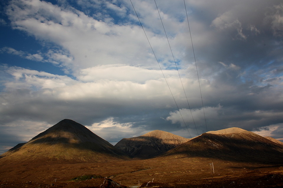
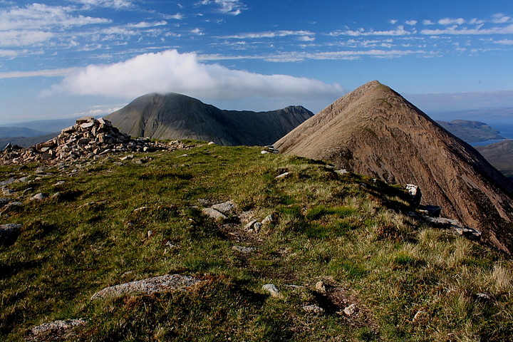
Isle of Skye
|
|
|
|
Sites in this group:
|
15 posts
Acairseid an Rubha Promontory Fort |
19 posts
2 sites Achadh Nam Bard Standing Stone / Menhir |
10 posts
Achaoh A'Chuirn Chambered Cairn |
|
1 post
An Corran Cave / Rock Shelter |
6 posts
An Reidhean Stone Circle |
55 posts
An Sithean Chambered Cairn |
|
2 posts
Armadale Barrow / Cairn Cemetery |
7 posts
Barpa Cairn(s) |
41 posts
Beinn na Cailleach Cairn(s) |
|
18 posts
Beinn na Caillich Cairn(s) |
10 posts
Beinn Na Caillich Chambered Cairn |
9 posts
Boreraig Stone Circle |
|
21 posts
Borve (Isle of Skye) Stone Row / Alignment |
6 posts
Cadha nan Ingrean Stone Fort / Dun |
12 posts
Cadha Riach Chambered Cairn |
|
2 posts
Camalaig Bay Cairn(s) |
16 posts
Carn Ban Stone Fort / Dun |
24 posts
Carn Liath, Kensaleyre Chambered Cairn |
|
12 posts
Carn Liath, Kilmuir Chambered Cairn |
9 posts
Carn Liath, Struanmore Chambered Cairn |
7 posts
Cille Brighde Cairn(s) |
|
1 post
Clachan Fhuarain Standing Stone / Menhir |
12 posts
Clach Ard Standing Stone / Menhir |
11 posts
Clach na h'annait Standing Stone / Menhir |
|
5 posts
Clach Oscar Standing Stone / Menhir |
7 posts
Claigan (Dun Breac) Stone Fort / Dun |
6 posts
Claigan Souterrain Souterrain |
|
16 posts
Cnocan Nan Cobhar Long Cairn |
8 posts
Cnoc Na Cairidh Stone Fort / Dun |
15 posts
Cnoc Ullinish Chambered Tomb |
|
5 posts
Creagan Soillier Stone Fort / Dun |
9 posts
Creag A' Chapuill Cave / Rock Shelter |
7 posts
Creag Nam Meann Stone Fort / Dun |
|
18 posts
Cuidrach Stone Setting Stone Circle |
19 posts
Druim Dubh Cairn(s) |
6 posts
Drumuie Standing Stone / Menhir |
|
4 posts
Dunanellerich Stone Fort / Dun |
6 posts
Dunan an Aisilidh Stone Fort / Dun |
10 posts
Dunan Choinnich Stone Fort / Dun |
|
9 posts
Duntulm Stone Fort / Dun |
6 posts
Dun Acardinon Stone Fort / Dun |
3 posts
Dun A'Cheitechin Broch |
|
10 posts
Dun a'Chleirich Stone Fort / Dun |
5 posts
Dun Adhamh Stone Fort / Dun |
12 posts
Dun Aird Stone Fort / Dun |
|
5 posts
Dun Alighlinn Broch |
13 posts
Dun Ardtreck Broch |
12 posts
Dun Ard an t-Sabhail Broch |
|
12 posts
Dun Arkaig Broch |
10 posts
Dun Ban Stone Fort / Dun |
4 posts
Dun Ban (Camuscross) Stone Fort / Dun |
|
30 posts
Dun Beag Broch |
24 posts
Dun Beag, Balmeanach Hillfort |
12 posts
Dun Beag Cairn Cairn(s) |
|
1 post
Dun Beag (Cairn) Cairn(s) |
10 posts
Dun Beag (Loch Slapin) Stone Fort / Dun |
5 posts
Dun Bernisdale Stone Fort / Dun (Destroyed) |
|
6 posts
Dun Boreraig Stone Fort / Dun |
12 posts
Dun Boreraig (Duirinish) Broch |
5 posts
Dun Bornasketaig Stone Fort / Dun |
|
21 posts
Dun Borrafiach Broch |
16 posts
Dun Borve Broch |
4 posts
Dun Borve, Cuidrach Stone Fort / Dun |
|
5 posts
Dun Borve (Greshornish) Broch |
5 posts
Dun Chaich Stone Fort / Dun |
4 posts
Dun Chlo Stone Fort / Dun (Destroyed) |
|
6 posts
Dun Cnoc a'Sga Stone Fort / Dun |
10 posts
Dun Colbost Broch |
11 posts
Dun Connavern Stone Fort / Dun |
|
6 posts
Dun Craig Stone Fort / Dun |
9 posts
Dun Cruinn Stone Fort / Dun |
6 posts
Dun Dearg Stone Fort / Dun |
|
10 posts
Dun Diarmaid, Bracadale Broch |
4 posts
Dun Druim nan Slochd Stone Fort / Dun |
8 posts
Dun Edinbane Broch |
|
9 posts
Dun Ela Stone Fort / Dun |
7 posts
Dun Eyre Stone Fort / Dun |
6 posts
Dun Faich Stone Fort / Dun |
|
3 posts
Dun Feorlig Broch |
28 posts
Dun Fiadhairt Broch |
10 posts
Dun Flashader Broch |
|
8 posts
Dun Flodigarry Broch |
5 posts
Dun Garafad Broch (Destroyed) |
8 posts
Dun Garsin, Bracadale Broch |
|
18 posts
Dun Gearymore Broch |
1 post
Dun Geilbt Stone Fort / Dun |
13 posts
Dun Gerashader Stone Fort / Dun |
|
18 posts
Dun Grianan Broch |
7 posts
Dun Grianan (Tote) Stone Fort / Dun |
35 posts
Dun Grugaig Stone Fort / Dun |
|
20 posts
Dun Hallin Broch |
5 posts
Dun Hollan Stone Fort / Dun |
20 posts
Dun Kearstach Stone Fort / Dun |
|
3 posts
Dun Kingsburgh (North) Broch |
4 posts
Dun Kingsburgh (South) Broch |
5 posts
Dun Knock Hillfort |
|
11 posts
Dun Kraiknish Stone Fort / Dun |
5 posts
Dun Liath (Glasnakille) Broch |
15 posts
Dun Liath, Kilmuir Stone Fort / Dun |
|
13 posts
Dun Maraig Stone Fort / Dun |
17 posts
Dun Merkadale Stone Fort / Dun |
18 posts
Dun Mor Stone Fort / Dun |
|
7 posts
Dun Mor, Struanmore Stone Fort / Dun |
11 posts
Dun na h'Airde Stone Fort / Dun |
6 posts
Dun Neill Promontory Fort |
|
15 posts
Dun Osdale Broch |
4 posts
Dun Peinduin Stone Fort / Dun |
10 posts
Dun Raisaburgh Broch |
|
16 posts
Dun Ringill Stone Fort / Dun |
9 posts
Dun Santavaig Stone Fort / Dun |
5 posts
Dun Sgalair Stone Fort / Dun |
|
16 posts
Dun Skudiburgh Stone Fort / Dun |
19 posts
Dun Sleadale (Talisker) Broch |
4 posts
Dun Smail Stone Fort / Dun |
|
15 posts
Dun Suladale Broch |
14 posts
Dun Taimh Hillfort |
6 posts
Dun Tom na h-Uraich Stone Fort / Dun |
|
7 posts
Dun Torvaig Stone Fort / Dun |
2 posts
Dun Torvaig Ancient Village / Settlement / Misc. Earthwork |
6 posts
Dun Totaig Stone Fort / Dun |
|
6 posts
Dun Treaslane Stone Fort / Dun |
19 posts
Dun Vallerain Hillfort |
4 posts
Dun View Stone Fort / Dun |
|
7 posts
Dun Vlargveg Stone Fort / Dun |
1 post
Eilean Ruaridh Hillfort |
22 posts
Eyre Standing Stones |
|
13 posts
Eyre Manse Cairn(s) |
7 posts
Geary Promontory Fort |
5 posts
Glen Heysdal Broch |
|
16 posts
Healabhal Mhor Round Cairn |
3 posts
High Pasture Cave Cave / Rock Shelter |
6 posts
Kensaleyre Church Cairn(s) |
|
1 post
Kilbride Stone Circle |
8 posts
Kilchriosd Stone Circle |
5 posts
Kilmarie Stone Circle |
|
2 posts
Kilmore Christianised Site |
20 posts
Kilvaxter Souterrain |
1 post
Knock Ullinish Souterrain |
|
12 posts
Leitir Fura Promontory Fort |
13 posts
Liveras Chambered Tomb |
5 posts
Lochan nan Dunan Stone Fort / Dun |
|
8 posts
Loch Leum na Luirginn Stone Fort / Dun |
1 post
Lon Beatha Cairn(s) |
10 posts
The Maidens Natural Rock Feature |
|
7 posts
Meall An Duna Stone Fort / Dun |
36 posts
Na Clachan Bhreige Stone Circle |
16 posts
Old Man of Storr Natural Rock Feature |
|
5 posts
Osmigarry Standing Stone / Menhir |
1 post
Port na Faganaich Natural Rock Feature |
1 post
The Raven's Stone Standing Stone / Menhir |
|
9 posts
Rigg Promontory Fort |
6 posts
River Sligachan Stone Circle |
1 post
Rocabarra Standing Stone / Menhir |
|
9 posts
Romesdal Bridge Cairn(s) |
27 posts
Rubh an Dunain Chambered Cairn |
23 posts
Rubh an Dunain Broch |
|
8 posts
Rubh An Dunain Cairn(s) |
1 post
Rudha nan Clach Standing Stones |
7 posts
Sgoir Beag Promontory Fort |
|
7 posts
Snizort Parish Church Cairn(s) |
4 posts
The Table, Quiraing Natural Rock Feature |
2 posts
Temple of Anaitis |
|
9 posts
Tote (Skeabost) Chambered Cairn |
6 posts
Tot Nan Druidhean Cairn(s) |
3 posts
Trumpan Cairn(s) |
|
1 post
Uig Cairn(s) |
27 posts
Vatten Cairn(s) |
1 post
The Weeping Stone |
Sites of disputed antiquity:
|
9 posts
Heaven Stone Holed Stone |
1 post
Teampuill Chaon Christianised Site |
News |
|
|
60 million-year-old meteorite impact found on Skye Geologists have found evidence of a 60 million-year-old meteorite impact on the Isle of Skye. http://www.bbc.co.uk/news/uk-scotland-highlands-islands-42351959 |
14th December 2017ce |
The Atlas of Hillforts of Britain and Irelandhttps://hillforts.arch.ox.ac.uk/ I have spent some time examining this database, which was released into the public domain in June 2017, most particularly with respect with the area I am most familiar with: The Isle of Skye... continues... |
 Posted by LesHamilton
6th July 2017ce Edited 6th July 2017ce |
Mesolithic hazel nut shells foundhttp://archaeology... continues... |
 Posted by tjj
25th October 2015ce Edited 25th October 2015ce |
|
Skye Cave Find Western Europe's 'earliest string instrument' http://www.bbc.co.uk/news/uk-scotland-highlands-islands-17537147 |
29th March 2012ce |
|
Burial site find delays new Skye medical centre http://www.bbc.co.uk/news/uk-scotland-highlands-islands-14509160 |
 Posted by strathspey
12th August 2011ce Edited 14th August 2011ce |
Prehistoric cave on Skye "Still occupied"A cave thought to have been occupied by people as early as 3BC was still being lived in this year, it has emerged. A new hearth for a fire and stacks of wood cut for kindling were found in the L-shaped fissure at Leitir Fura, Kinloch, on Skye... continues... |
 Posted by thesweetcheat
24th August 2010ce Edited 24th August 2010ce |
|
Seventh Grave Discovered At Skye Bronze Age Site The latest find is thought to be even older than the six burials previously found. First published 23/12/09. More on: http://www.pressandjournal.co.uk/Article.aspx/1536528 |
23rd December 2009ce |
Tide turns on Iron Age midden treasure troveAN ANCIENT rubbish tip – inhabited nearly 2,000 years ago – is disappearing into the sea, archeologists have warned. The Iron Age midden on Skye's west coast has so far yielded bone fragments, stone tools, a button manufactured from horn and the top of a human skull... continues... |
 Posted by moss
11th December 2009ce Edited 11th December 2009ce |
|
Prehistoric burial ground found on Skye http://www.pressandjournal.co.uk/Article.aspx/1467854?UserKey= |
 Posted by fitzcoraldo
4th November 2009ce |
Rare Iron Age Burial Found on SkyeArchaeologists believe they have uncovered the first Iron Age burial on the Isle of Skye. The skeleton from about the 1st millennium BC is thought to be that of a young female. It was found recently in an open stone-lined grave as the archaeologists worked to re-open the blocked entrance to the High Pasture Cave... continues... |
 Posted by Rhiannon
8th September 2005ce Edited 8th September 2005ce |
Images (click to view fullsize) |
|
|
Folklore |
|
| I heard some folklore today, unprompted, and I hope the person who told it won't mind me retelling it here. He said that when his father was young (this might be about 60 or more years ago) he lived on Skye for a while, and he'd gone on a long walk over the Cuilleans, accompanying a local man. It took them five hours to get across the mountains and his father then assumed they'd walk the flat way back, along the road. But he was very surprised when his guide said 'well goodbye then' and made to set off the way they'd come. It transpired that the short route home went past a green mound (where, my narrator said, there were, as we would say, fairies, but it was a bronze age burial mound) - and the guide was under no circumstances about to walk past it now that the dusk was falling. He would rather take the five hours back over the mountains in the dark. Which, according to the tale, he did. |
Posted by Rhiannon 18th November 2010ce Edited 18th November 2010ce |
|
The pattern of distribution of monuments near the Red Cuchuillin mountains is very striking, when viewed on the map, for their locations draw a curve around the southern and eastern sides, the monuments roughly equally spaced and delineating the edge of the mountains perfectly. The Red Cuchuillins, then, seem to be of central significant in the positioning of these sites. They are the easternmost part of the Cuchuillin range, the creation of which is described in folklore thus: "When all the world was new, there was a great heather-clad plain between Loch Bracadale on the west and the Red Hills on the east. It was a dark and lonely place and the Cailleach Bhur (= Hag of the Ridges, i.e. Winter), whose home was on Ben Wyvis, often lived there when she came west to boil up her linen in her washing pot, dangerous Corryvreckan. She was a very powerful and fearsome person who had made Scotland by dropping into the sea a creel of peat and rock which she brought with her from the north. When her clothes had boiled well, she would spread them to bleach on Storr, and while she was in Skye no good weather was to be got at all. Now spring hated her because she held the maiden he loved prisoner (until the girl should wash a brown fleece white) and he fought with her, but she was strong, stronger than anyone else within the four boundaries of the earth, and he could do nothing. He appealed to the Sun to help him and the Sun flung his spear at Cailleach Bhur as she walked on the moor; it was so fiery and hot it scorched the very earth, and where it struck, a blister, six miles long and six miles wide, grew and grew until it burst and flung forth the Cuchuillins as a glowing, molten mass. For many, many months they glowed and smoked, and the Cailleach Bhur fled away and hid beneath the roots of a holly and dared not return. Even now, her snow is useless against the fire hills. - Otta F. Swire, Skye: The Island and its Legends, 1961, pp. 20-1. (for more on the Cailleach Bhur in Skye see also Rudha nan Clach) The Cuchuillins are also noted, in mythology, for the "school for heroes" run by Skiach, "goddess or mortal no one knows which, but undoubtedly a great warrior. Some say she took her name from a Gaelic name for Skye, others that Skye took its name from her" (see Swire pp. 21-3). The Irish hero Cuchuillin, for whom these mountains are named, heard of Skiach and her school, and with three strides travelled from Ulster to her school. After defeating every one of her students, Skiach finally allowed him to fight with her daughter, whom he also vanquished, after two days. Furious, Skiach descended from her heights to fight Cuchuillin herself. After two days of fighting "on the mountains and on the moors and in the sea" the combat was exactly equally matched, with neither able to gain the upper hand. At this stage Skiach's daughter offers both her mother and Cuchuillin a meal of deer stuffed with roast hazelnuts. Each thinking that "the hazels of knowledge" would teach them how to overcome their opponent, the two of them sit down to eat. From the hazels they learn that they are exactly matched, and that neither will ever win over the other. They therefore make peace, and swear that each will answer the other's call, "though the sky fall and crush us". Skiach named the mountains where they had fought in Cuchuillin's honour. Swire (Ibid., p. 23) records one further curious piece of folklore with regard to the Cuchuillins: "In the Cuchuillins, too, though exactly where must not be said, is a cave of gold. Unlike all other treasure caves, there are no barriers here between men and untold wealth. No magic word is required. No fearful monster guards the entrance. He who finds the cave may take as much gold as he needs and return as often as he desires more, but each time he enters the cave, and each time he uses the gold, he will become a little more evil and a little more evil, until he loses his soul. That is the price." |
 Posted by TomBo
30th June 2004ce Edited 22nd March 2011ce |
Miscellaneous |
|
|
"Many people believe that it is from her wings* and her Gaelic name, Eilean Sgiathanach (Winged Isle), that the name Skye comes. Ptolemy of Alexandria (A.D. 200) refers to the island as Sketis, while the ancient Celtic name 'Skeitos' has become Sgiath in modern Gaelic. Adamnan knew it as Scia. This 'wing derivation certainly sounds very probable, more probable than the other version which claims that 'Skye' is Scandinavian, derived from a norse word Ski (cloud). This school of thought takes its stand on the fact that cloud or mist is what would first and most forcibly attract the notice of any stranger visiting the isle**, whereas to notice the 'wings' requires a map. Obviously this school has never tried (as the early Scandinavian settlers most certainly did) to sail around the despised wings. Of course, many place-names in Skye undoubtedly are Scandinavian, but they date from a later time than Ptolemy - four or five centuries later. A third suggestion, once seriously put forward by certain Celtic antiquaries, was that in Skye stood the temple, known to Greek fable, of Apollo among the Hyperboreans, and that the Gaelic name of the island refers to the wings of the Greek god! The name may, in fact, belong to some old forgotten pre-Celtic tongue." - Otta F. Swire, Skye: The Island and its Legends, 1961, pp. 72-3. * The "wings" are Skye's various promontories, for example Trotternish, Waternish and Duirnish. ** Skye is also known as Eilean a' Cheò, meaning "The Misty Isle". |
Posted by TomBo 1st July 2004ce Edited 1st July 2004ce |
|
"Strath appears to have been a great religious centre ever since prehistoric times. The remains of several stone circles are still to be seen there, in close juxtaposition to a number of ancient churches now in ruins. It seems generally agreed that before St. Columba brought Christianity to Skye the pagan religion of the island was that mysterious cult which has come to us only in the form of stone circles (believed to have been places of worship), monoliths (which in Skye seem to have been frequently connected with graves or burial mounds), and sacred wells and woods, the latter usually hazel groves. St. Columba never attempted to destroy the sacred places of paganism nor the firm belief in the virtues of certain harmless practices he found: instead he blessed them and gave them Christian symbolism, as in the story of St. Turog and the wells at Flodigarry. This is very clearly illustrated in Strath, where five old churches or chapels, now in ruins, stand each beside or near a stone circle, and the graveyards all contain some prehistoric stones as well as having tradition that they were first pagan burial-grounds and later Christian." - Otta F. Swire, Skye: The Island and its Legends, 1961, pp. 217-8. |
Posted by TomBo 30th June 2004ce Edited 22nd March 2011ce |
Latest posts for Isle of Skye |
Showing 1-10 of 1,710 posts. Most recent first | Next 10 
Vatten (Cairn(s)) — Folklore |
It is unclear why the two cairns were built together, but local folklore provides its own interpretations. One tale is that one of the mounds is the burial place of a great chief who owned the surrounding land. Each summer he went on a raiding mission with his men, bringing back gold, cattle and slaves. One summer he did not return when expected, but in the autumn the ships sailed slowly into the bay. The body of the chief was carried ashore on his men's shields to be buried in a huge grave, while in the bay below, his galley was ritually set alight.In 'Prehistoric Scotland' by Ann MacSween and Mick Sharp (1989). |
Posted by Rhiannon 9th January 2024ce |
Kilvaxter (Souterrain) — Fieldnotes |
|
Taking the coastal route on the A855 from Portree to Uig we stopped to give the the souterrain at Kilvaxter another visit. It appears the entrance has narrowed as it seemed a tighter squeeze than my last visit. The only thing to add to previous fieldnotes is that the site and surrounding area, including the nut circle, needs a good tidy up if it is to pull in a fair number of visitors. Anyway, onto Uig and ferry to Lochmaddy. Visited 05/08/2023. |
24th December 2023ce |
Rubh An Dunain (Cairn(s)) — Fieldnotes |
|
Of the four sites this one probably has the best views of the dun, chamber cairn, cave, naust / canal, loch, mountains and sea. On our visit the sea, Camas a Mhurain - Gulf of the Sea, was an astonishing colour of blue. The cairn sits at nearly 13m wide and is 1.1m tall. Lots of stonework can be seen poking through the well manicured turf, local greenkeepers do an excellent job. Decent kerbs can be seen situated around the site. Probably a lot of stones have been used in the building of the dyke which seperates the two cairns. Now we made our way back to the main track via a route suggested by a site that promotes highland treks / walkways. This led us around the west of Carn Mor, there is no path of any kind, it goes near the top of cliffs and in parts is an ankle breaker. Take the main track back, we were mightily relieved to emerge unscathed back to the track along with the dog. That site will never be used again. Apart from track malfunction everything at Rubh An Dunain was as perfect as perfect could be. Great weather, great place. Visited 04/08/2023. |
30th November 2023ce |
Rubh an Dunain (Chambered Cairn) — Fieldnotes |
|
From the dun we crossed the Viking-made canal via handily placed causeway and made our way round the sound side of Loch na h'Airde before heading north towards the cairns that are located in front of the small hill, Carn Mor. As Mr G said this is an isolated place nowadays but it once appeared to be reasonably populated with the nearby dun, medieval townships and various Nordic visitors. Now the closest people are at Glen Brittle, the most regular visitors being sheep and cows along with people making the trek to the various sites. The chambered cairn still sits at 20m wide and a good gentle tidy would reveal that a lot of it is still in place. Large slabs and some well built dry stanes remain in place. A gentle restoration would be wonderful to see but given the location, highly unlikely. The view as ever remains glorious and we're lucky that we have made it on a beautiful clear day day which seemed unlikely given the previous nights dreich stuff. Not far to the next site, a wee jump over a wall. Visited 04/08/2023. |
30th November 2023ce |
Rubh an Dunain (Broch) — Fieldnotes |
|
Following almost in Les's footsteps, diversions via a cave and the dog trying to find alternative routes, we eventually made it to the superb galleried dun at Rubh an Dunain. With A being interested in nausts, this was a superb opportunity to closely look at both, with the cairns afterwards. The Sound of Soay, Loch Brittle, The Cuillins and Loch na H'Airde along with the island of Rum provide wonderful backdrops to this lonely, but obviously not that lonely in past times, place. The dun is galleried within its large wall along with a door check, rivalling those near Tayvallich. Sadly erosion will play a role here and perhaps has done so in the past, any surrounding wall has gone. Entrance to the site is via a small climb up from the Viking canal. Turn round to see the the mountains - stunning. Visited 04/08/2023. |
13th November 2023ce |
Creag A' Chapuill (Cave / Rock Shelter) — Fieldnotes |
|
First stop on our way to the famous dun, cairns and naust was the cave at Creag A' Chapuill. Parking is available near the Glen Brittle camp site. We were lucky, a beautiful day for a wonderful walk. Discoveries have placed occupation or use of the cave around the same time as the cairns were built, finishing around the the completion of the dun. To me it had an appearance of a shop as flat topped rock at the entrance resembled a shop counter. It certainly had good views as the nearby prehistoric monuments as well as Loch na h'Airde can be seen to the west. The shop idea might be close as various pottery and later iron slag were found at the site. Also found was an oar shaped piece of wood, to me it looked like the shape of a wooden tool I'd seen used at a demonstration at Archeolink beside Oyne, sadly now closed. An interesting place. I headed south west from the path at the medieval MacAskill township, heading across a surprisingly dry valley, only a small stream to jump. The cave be seen from here so reasonably easy to find with the ascent to the site being fairly easy. However, cut across back to the main path as south of the cave is boggy when heading to the dun and cairns. Wonderful views. Visited 04/08/2023. |
6th November 2023ce |
Cille Brighde (Cairn(s)) — Fieldnotes |
|
In what has been described as an old church, the remains of a stone circle is instead the remains of a much disturbed cairn some 17m wide and 0.5m high. Parts of the cairn can be spotted as a small bank in which several kerbs still remain. The large stone may have stood or it might simply have always been there. From the standing stone at Clach Na h'Annait, I circled round Kilbride House in an anti clockwise direction, climbing one wall, then jumping the Allt Na Leth-Pheighinne stream, which by this time because of heavy rain seemed to be getting deeper and wider. Walk into the field, head straight west and look for the small trees. The site is most definitely next to edge of a former loch which I can verify is now very boggy. After a good splash around it was back over the burn to walk back up the road to the car. A bit of a 'what' if but a nice wee stop despite the dreich conditions. Visited 03/08/2023. |
29th October 2023ce |
Clach na h'annait (Standing Stone / Menhir) — Fieldnotes |
|
Parking is available just beyond the track to Ashbank, near the minor road that leaves the B8083. From there I walked towards Kilbride House and simply opened a gate to walk to the standing stone, slightly to the east. Clach na h'annait means 'Stone Of The Mother Church' and it stands at nearly 2.4m. The stone has faired much better than the church, it has long since vanished. An impressive stone with atmosphere added by low clouds and rain. Visited 03/08/2023. |
22nd September 2023ce |
An Sithean (Chambered Cairn) — Fieldnotes |
|
Mr G's meandering sheep were visiting the cairn at the same time we meandered up to the same site. Still impressive amongst some of Scotland's best and rugged scenery. There is something about driech misty days that seem to age a site, almost like in very old forests - the whole atmosphere changes. The remains of the chamber, like dodgy teeth in a kerb cairn, are still in place and the impressive width, regardless of who put it there, shows how clever the builders were - they took advantage of what was there. Happily I took more in than my last visit - playing at the 1986 Broadford Music Festival at the airstrip. A nice walk to clear the head. I've been to Skye many times since so it was nice to go back down the Elgol road. Visited 03/08/2023. |
19th September 2023ce |
Kilvaxter (Souterrain) — Images (click to view fullsize) |
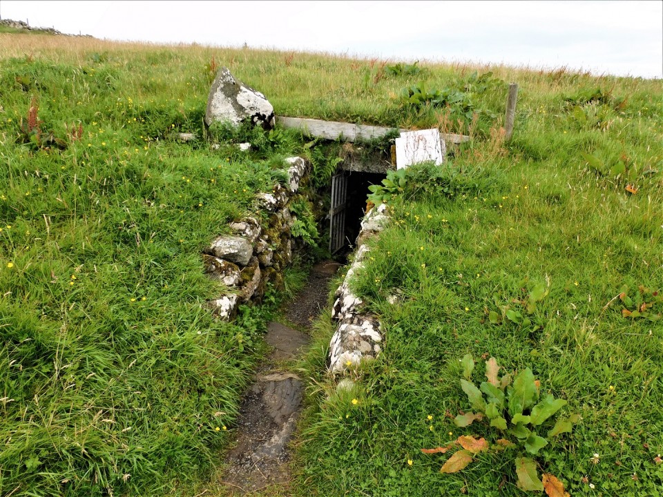
|
23rd August 2023ce |
Showing 1-10 of 1,710 posts. Most recent first | Next 10