Showing 1-50 of 698 posts. Most recent first | Next 50 
A long and fascinating article on the Lansdown Plateau and its' barrows by Mike Williams.
|
A Neolithic Feat of Engineering
The ruins of a 5,000-year-old tomb in a construction that reflects the pinnacle of neolithic engineering in northern Britain has been unearthed in Orkney.
Fourteen articulated skeletons of men, women and children – two positioned as if they were embracing – have been found inside one of six cells or side rooms.
The tomb measures more than 15m in diameter and contains a stone structure accessed through a long passage of around seven metres. The excavation was headed by Dr Hugo Anderson-Whymark, senior curator of prehistory (neolithic) at the National Museums Scotland, and Vicki Cummings, professor of neolithic archaeology at Cardiff University.
https://www.theguardian.com/uk-news/2023/oct/21/a-neolithic-feat-of-engineering-orkney-dig-reveals-ruins-of-huge-tomb
|
This is a Youtube link taken from the website of Robjn Cantus - Inexpensive Progress. If you like/love Paul Nash's artistic work it is fascinating. But also as a historical footnote. Enjoy.
https://www.youtube.com/watch?v=DyqIDGDPTqw
|
Yorkshire's 'Stonehenge of the North' gifted to the nation
Three huge Neolithic monuments in Yorkshire which have been described as "the Stonehenge of the North" have been gifted to the nation.
The Thornborough Henges complex, near Ripon, date back to around 3500BC to 2500BC and consist of three 656ft (200m) wide circular earthworks.
Two construction firms have donated the henges site to Historic England.
They will now be managed by English Heritage and will be opened free of charge to the public.
Historic England chief executive Duncan Wilson said the henges were probably the most important single ancient site between Stonehenge and the Orkney Islands in Scotland......
https://www.bbc.com/news/uk-england-york-north-yorkshire-64499428
|
‘Weird, wonderful’: rare dig at Arthur’s Stone writes new story of neolithic site
High above one of western Britain’s loveliest valleys, the silence is broken by the sound of gentle digging, scraping and brushing, along with bursts of excited chatter as another ancient feature is revealed or a curious visitor stops by to find out what is going on.
This summer archaeologists have been granted rare permission to excavate part of the Arthur’s Stone site, a neolithic burial plot with soaring views across the Golden Valley in Herefordshire and the Black Mountains of south-east Wales.
https://www.theguardian.com/science/2022/jul/22/weird-wonderful-rare-dig-at-arthurs-stone-writes-new-story-of-neolithic-site
|
Fyfield Down in Wiltshire delisted as a nature reserve
One of Wiltshire’s most important wild landscapes has been delisted as a nature reserve. Fyfield Down, just east of the famous stone circle at Avebury, was leased to the Nature Conservancy (a predecessor of Natural England) in 1955 and declared an NNR in 1956. It has been described as the “best assemblage of sarsen stones in England”. The site lies within the Avebury World Heritage Site and the North Wessex Downs AONB.
https://tinyurl.com/mr2smb2
|
Winter Solstice at Maes Howe Cairn. Interesting information to be listened to from the professor and the expert on Scandinavian runes. But it is 41 minutes long.
|
Extremely rare prehistoric animal carvings found for first time in Scotland
Historic Environment Scotland (HES) said the carvings - thought to be between 4,000 and 5,000 years old - were discovered inside Dunchraigaig Cairn in Kilmartin Glen, Argyll.
They are thought to date to the Neolithic or Early Bronze Age, and include images of deer.
Hamish Fenton, who has an archaeology background, found them by chance.
Kilmartin Glen is viewed as one of the most important concentration of Neolithic and Bronze Age remains in mainland Scotland.
Valuable as sources of meat, hides, and with bones and antlers used for a variety of tools, HES said deer would have been very important to local communities at the time.
https://www.bbc.co.uk/news/uk-scotland-57304921
|
Peterborough: Bronze Age boats conservation gets funding
Eight "internationally significant" Bronze Age wooden boats found in a quarry have been awarded funding for ongoing conservation work.
The vessels were discovered by archaeologists as they excavated land at Must Farm near Peterborough in 2011.
Historic England has awarded £73,261 to preserve the log boats as part of a three-year project.
Tony Calladine, from the heritage organisation, said the boats were "incredibly rare".
https://tinyurl.com/4xnd65fd
|
Stonehenge: Did the stone circle originally stand in Wales?
One of Britain's biggest and oldest stone circles has been found in Wales - and could be the original building blocks of Stonehenge.
Archaeologists uncovered the remains of the Waun Mawn site in Pembrokeshire's Preseli Hills.
They believe the stones could have been dismantled and rebuilt 150 miles (240 km) away on Salisbury Plain, Wiltshire.
The discovery was made during filming for BBC Two's Stonehenge: The Lost Circle Revealed.
The Welsh circle, believed to be the third biggest in Britain, has a diameter of 360ft (110m), the same as the ditch that encloses Stonehenge, and both are aligned on the midsummer solstice sunrise.
And one of the bluestones at Stonehenge has an unusual cross-section which matches one of the holes left at Waun Mawn, suggesting the monolith began its life as part of the stone circle in the Preseli Hills before being moved.
https://www.bbc.co.uk/news/uk-wales-56029203
And was Kammer the first to recognise this?
https://www.themodernantiquarian.com/site/3992/waun_mawn_row_circle.html
|
Druids face defeat as bulldozers get set for Stonehenge bypass
It has been bitterly debated for the past three decades, but the latest plans to partly bury the A303 in a tunnel beside Stonehenge may this week finally get approval from transport secretary Grant Shapps.
The £2.4bn scheme – which will see the traffic-choked road to the west country widened into a dual carriageway near the ancient site before shooting down a two-mile tunnel – has pitted archaeologists, local campaigners and even the nation’s druids against the combined might of Highways England, English Heritage and the National Trust.
https://www.theguardian.com/uk-news/2020/nov/07/druids-face-defeat-as-bulldozers-get-set-for-stonehenge-bypass
Spot the howler in the headline!
|
Star Carr: North Yorkshire's archaeological 'Tardis' 10 years on
The archaeologist who helped lead the dig that found Britain's oldest house said the site was still giving up its secrets 10 years on.
Star Carr hit the headlines in 2010 when a circular Stone Age structure found was dated to about 8,500 BC.
Archaeologist Nicky Milner said working on the site was akin to time-travel.
"It's as close as you can get to being in a Tardis. It was an absolute dream, it took up 15 years of my life," Dr Milner said.
Ray Mears, bushcraft expert and TV presenter, was one of those who helped unlock the purpose of wood found at the site.
Star Carr is a Mesolithic, or Middle Stone Age, site near Scarborough in North Yorkshire dating to almost 11,000 years ago.
https://www.bbc.co.uk/news/uk-england-york-north-yorkshire-53765350
|
Iron Age hillfort found in Chiltern Hills with help of 'citizen scientists'
An Iron Age hillfort hidden under trees and foliage has been discovered with the help of "citizen scientists".
Members of the Beacons of the Past group identified the site, in the Chiltern Hills, from digital survey images last year and the hillfort was verified on 6 August.
It is thought the circular site dates from the early Iron Age in England, between 800BC and 500BC.
Work will take place to preserve the site.
https://www.bbc.co.uk/news/uk-england-beds-bucks-herts-53741441
|
Stonehenge: Neolithic monument found near sacred site
Archaeologists have discovered a ring of prehistoric shafts, dug thousands of years ago near Stonehenge.
Fieldwork has revealed evidence of a 1.2 mile (2km) wide circle of large shafts measuring more than 10m in diameter and 5m in depth.
They surround the ancient settlement of Durrington Walls, two miles (3km) from Stonehenge.
Tests suggest the ground works are Neolithic and were excavated more than 4,500 years ago.
Experts believe the 20 or more shafts may have served as a boundary to a sacred area connected to the henge.
A team of academics from the universities of St Andrews, Birmingham, Warwick, Glasgow and the University of Wales Trinity Saint David worked on the project
https://www.bbc.co.uk/news/uk-england-wiltshire-53132567
https://intarch.ac.uk/journal/issue55/4/index.html
|
Ancient Peak District stone circle damaged by campfires
"Serious" damage to a scheduled ancient monument in Derbyshire is being investigated by police.
The prehistoric Doll Tor stone circle, near Birchover in the Peak District, was targeted some time in the past few days.
Sam Grimshaw, who discovered the damage, said he was "very angry" when he found some smaller stones had been moved and several fires had been set.
Historic England has appealed to anyone with information to contact police.
Mr Grimshaw said he found stones had been moved to build a fire pit and for a seat, while other fires had been set.............
https://www.bbc.co.uk/news/uk-england-derbyshire-52853799
|
Unearthed Ancient British chieftain and probable shaman reveal secrets about old burial rituals
The once monumental final resting place of a probable prehistoric chieftain and, potentially, his shaman has been discovered in southwest England.
It’s one of the most fascinating archaeological discoveries in southern Britain in recent years. Significantly, the duo formed part of a remarkable social and political process which changed human history – and still shapes our world today.
The probable chieftain or prestigious leader – a man in his thirties or forties – had been interred underneath the centre of a large funerary mound which had been constructed specifically for him inside his own personal 20m diameter ditched enclosure.
https://www.independent.co.uk/news/science/archaeology/archaeology-anicent-british-chieftain-shaman-burial-ritual-a9480321.html
Note: It would be interesting to pinpoint this site near a confluence of four rivers..
|
Interesting observations on the work of sculptor Keir Smith.
|
Lewis stone circle has star-shaped lightning strike
Evidence of a "massive" lightning strike has been found at the centre of a stone circle in the Western Isles.
A single large strike, or many smaller ones on the same spot, left a star-shaped magnetic anomaly at the 4,000-year-old site in Lewis.
Scientists made the discovery at Site XI or Airigh na Beinne Bige, a hillside stone circle now consisting of a single standing stone.
The site is at the famous Calanais Standing Stones.
Scientists said the lightning strike, which was indentified in a geophysics survey, could show a potential link between the construction of ancient stone circles and the forces of nature.
They said the lightning struck some time before peat enveloped the stone circle at Site XI 3,000 years ago. The discovery is detailed in new research published online.
https://www.bbc.co.uk/news/uk-scotland-highlands-islands-50891787
|
Television historian speak out for Oswestry hillfort
Historian and television presenter, Professor Michael Wood, has expressed serious concern over plans to build houses within the historic landscape of Old Oswestry hillfort.
....................................
In a letter of objection he wrote: "I have followed with concern the proposed developments. The Iron Age hillfort of Old Oswestry is generally agreed to be the finest site of its kind in the Welsh Borders. Any development that threatens its setting, as this self-evidently does, in my view, therefore, should be refused.”
The popular historian said Oswestry’s northern gateway around the hillfort was an extraordinarily interesting - and rare - example of a medieval sacred landscape, which still awaited detailed research and survey. This, he said was is in addition to the area’s multi-phase heritage interest ranging from pre-Iron Age to WW1 military archaeology.
https://www.shropshirestar.com/news/local-hubs/oswestry/2019/07/30/television-historian-speak-out-for-oswestry-hillfort/
|
'Stunning' decorated Neolithic stone discovered in Orkney
Archaeologists have uncovered what they describe as a "stunning example" of Neolithic decorate stone in Orkney.
The notch-marked slab was discovered at Ness of Brodgar, the location of a well-preserved and sophisticated complex of stone buildings.
The site was built and occupied by people more than 5,000 years ago.
Archaeological excavations began at Ness of Brodgar more than 15 years ago and the site covers an area of about six acres (2.5 ha)....
https://www.bbc.co.uk/news/uk-scotland-north-east-orkney-shetland-49030379
http://www.nessofbrodgar.co.uk/
|
Steps to ancient hillfort well in Aberdeenshire uncovered
Archaeologists have revealed the steps to an ancient hillfort's well in Aberdeenshire.
The site on Mither Tap, a summit on Bennachie, a hill near Inverurie, was first recorded in the 1800s before being covered over.
University of Aberdeen's Northern Picts project said its excavation meant the steps could been seen for the first time in more than 200 years.
Archaeologists believe the steps could be 1,000 years old,
https://www.bbc.co.uk/news/uk-scotland-north-east-orkney-shetland-48675964
|
Mythical ' Sunken Kingdom' of Wales rises again
A prehistoric forest which was buried under water and sand more than 4,500 years ago and inspired a local legend has been uncovered on a Welsh beach.
The forest near the village of Borth, Ceredigion, Mid Wales, used to stretch for up to three miles along the shore between Ynys-las and Borth but eventually was buried under layers of peat, sand and saltwater.
The eerie remains of these ancient trees under Borth's beach have led to the local legend of the mythical Sunken Kingdom of Wales, called Cantre'r Gwaelod.
Folklore has it that Cantre’r Gwaelod, or the Sunken Hundred, was a once-fertile land and township stretching for 20 miles, but was lost beneath the waves in a mythical age.
According to tales passed down through the ages, disaster struck and Cantre’r Gwaelod was lost to floods when Mererid, the priestess of a fairy well, apparently neglected her duties and allowed the well to overflow. Some say that on a quiet day, they can hear the bells of the drowned church of Cantre’r Gwaelod.
Now the remains of the forest's trees have been exposed more clearly than ever by low tides and high winds from Storm Hannah.
https://www.dailymail.co.uk/sciencetech/article-7057361/Petrified-forest-Bronze-Age-emerged-Welsh-beach.html
|
Missing part of Stonehenge returned 60 years on
A metre-long core from inside the prehistoric stone was removed during archaeological excavations in 1958.
No one knew where it was until Robert Phillips, 89, who was involved in those works, decided to return it.
English Heritage, which looks after Stonehenge, hopes the sample might now help establish where the stones originally came from.
In 1958 archaeologists raised an entire fallen trilithon - a set of three large stones, consisting of two that would have stood upright with the third placed horizontally across the top.
During the works, cracks were found in one of the vertical stones and in order to reinforce it, cores were drilled through the stone and metal rods inserted.
https://www.bbc.co.uk/news/uk-england-wiltshire-48190588
|
Neolithic dog reveals tales behind Orkney's monuments
The head of a dog that lived on Orkney 4,500 years ago has been recreated in what experts believe is the world’s first canine forensic reconstruction.
The dog had been domesticated in the Neolithic era on the Scottish island archipelago, but still carried wolf-like characteristics, standing about the size of a large collie, according to Historic Environment Scotland (HES) which jointly commissioned the reconstruction with the National Museum of Scotland.
It was reconstructed by a forensic artist – using techniques similar to those by crime scene investigators – from one of 24 dog skulls that were excavated by archaeologists in Cuween Hill, a delicate passage tomb on Orkney’s Mainland, and which have been radiocarbon-dated to 2,500BC.
https://www.theguardian.com/uk-news/2019/apr/13/neolithic-dog-reveals-tales-behind-orkney-monuments
|
A description of this area - Garrick Moor
|
The gateway to hell? Hundreds of anti-witch marks found in Midlands cave
Medieval vandalism?
If there is a gateway to hell, a portal from the underworld used by demons and witches to wreak their evil havoc on humanity, then it could be in a small east Midlands cave handy for both the M1 and A60.
Heritage experts have revealed what is thought to be the biggest concentration of apotropaic marks, or symbols to ward off evil or misfortune, ever found in the UK.
The markings, at Creswell Crags, a limestone gorge on the Nottinghamshire/Derbyshire border, include hundreds of letters, symbols and patterns carved, at a time when belief in witchcraft was widespread. The scale and variety of the marks made on the limestone walls and ceiling of a cave which has at its centre a deep, dark, hole, is unprecedented....
https://www.theguardian.com/culture/2019/feb/15/nottinghamshire-cave-carvings-marks-scare-witches
|
Ancient Carved 'Drums' Give Exact Stonehenge Measurements, Say Archaeologists
A set of highly decorated chalk cylinders, carved in Britain more than 4,000 years ago and known as the Folkton drums, could be ancient replicas of measuring devices used for laying out prehistoric monuments like Stonehenge, archaeologists say...
https://www.livescience.com/64603-ancient-carved-drums-measure-stonehenge.html
|
Ancient platform 'damaged' during Stonehenge tunnel work
Archaeologists have accused Highways England of accidentally drilling a large hole through a 6,000-year-old structure near Stonehenge during preparatory work for a tunnel.
The drilling, which is alleged to have taken place at Blick Mead, around a mile and a half from the world-famous neolithic ring of stones, has enraged archaeologists, who say engineers have dug a three-metre-deep hole (10ft) through a man-made platform of flint and animal bone.
Highways England have said they are not aware of any damage to archaeological layers on the site caused by their work and will meet with the archaeological team on Thursday, led by David Jacques, a senior research fellow at the University of Buckingham.......
https://www.theguardian.com/uk-news/2018/dec/06/ancient-platform-damaged-during-stonehenge-tunnel-work
|
Latest news on the protection of these caves.
|
Pembrokeshire treasure hunter unearths Celtic chariot
A metal detectorist has found what is thought to be the first Celtic chariot burial to be uncovered in Wales.
The burial ritual was reserved for high-ranking chiefs who would be interred complete with their chariot, horses, tack and even weapons.
Mike Smith believes his find may point to a huge undiscovered Iron Age settlement nearby.
National Museum Wales describes the finds as "significant and exciting".
The actual location in south Pembrokeshire is being kept secret while archaeologists prepare for a major dig next year.
https://www.bbc.co.uk/news/uk-wales-46294000
|
Scotland’s oldest heritage sites at risk from rising seas
Off the north coast of Scotland, Orkney’s soft green landscapes hold a trove of things from everyday life before history was written.
More than 3,000 archaeological sites — among them standing stone circles, Norse halls and a Neolithic tomb graffitied by Vikings — have endured for millenniums, scattered across the roughly 70 islands that make up the Orkney archipelago.
At Skara Brae, one of Europe’s best-preserved Stone Age villages, kitchens built around 3180 BC are fitted with hearths and cupboards, bedsteads and doors that could be bolted shut.
Today, in forays to remote spits of land, people are working to save some of these places for posterity from the climate changes accelerated by human activity.
About half of Orkney’s 3,000 sites, many built before Stonehenge or the pyramids, are under threat from those changes, according to the county archaeologist. Some are already being washed away.
Since 1970, Orkney beaches have eroded twice as fast as in the previous century. Others that had been stable are now shrinking. Rains, falling heavier and more often, are dissolving the crusts of soil and sand packs that protect remnants of civilizations.
https://www.sbs.com.au/news/scotland-s-oldest-heritage-sites-at-risk-from-rising-seas
|

|
Archaeologists Find 2,000-Year-Old Wooden Bowl, plus hair
The Iron Age artifacts were sealed in a subterranean chamber of the Cairns Broch, a tower-like stone structure.
uring the Iron Age, the Cairns Broch—a tower-like stone building of monumental proportions—dominated the landscape of Windwick Bay, a rocky cove in the Scottish archipelago of Orkney. Equal parts house, fort and status symbol, the broch stood at the center of an ancient settlement until some point between the later 1st and mid-2nd century A.D., when it was sealed and subsequently abandoned.
Read more:
https://www.smithsonianmag.com/smart-news/archaeologists-find-2000-year-old-wooden-bowl-strands-hair-northern-scotland-180969713/
And also, if you can get through the adverts at the Independent, there is this with a video...
https://www.independent.co.uk/news/uk/home-news/2000-year-old-bowl-underground-chamber-orkney-scotland-archaeology-a8447421.html
|
Prehistoric stone hunt under way in Devon salt marsh
A team of archaeologists is braving horse flies, spiky vegetation and murky ditches to hunt for mysterious standing stones lost beneath a West Country salt marsh.
The Yelland stone row at Isley Marsh disappeared beneath a thick blanket of silt after the closure of a power station changed the flow of sediment in the Taw and Torridge estuary in north Devon in the 1980s.
https://www.theguardian.com/science/2018/jun/27/prehistoric-stone-hunt-under-way-in-devon-salt-marsh
|
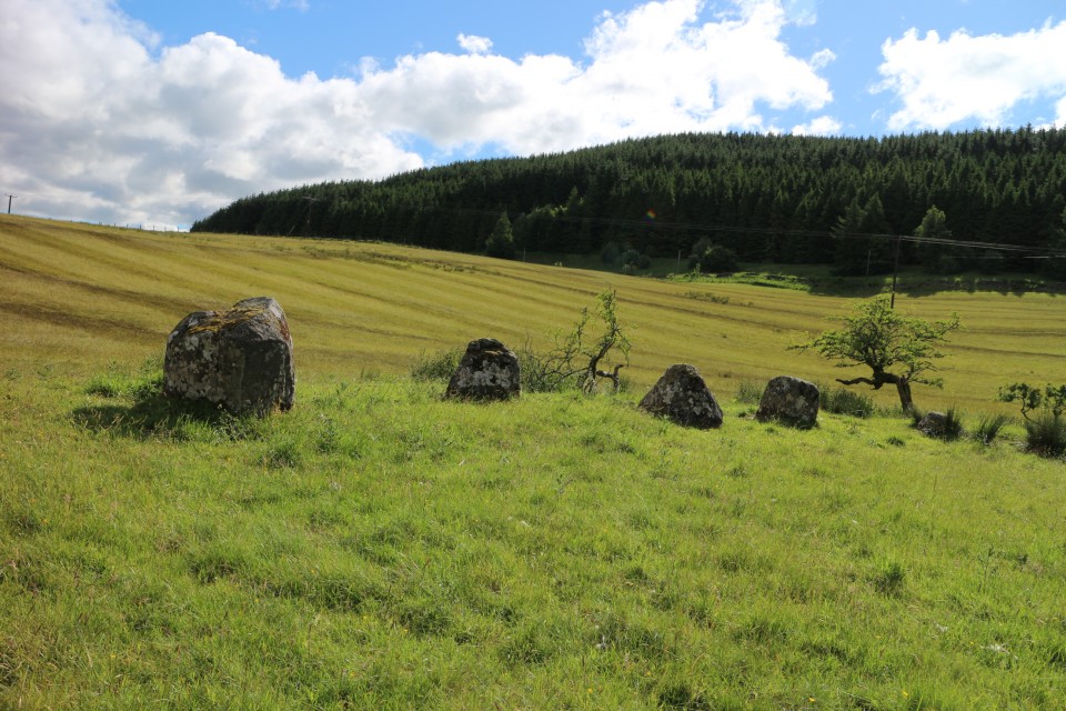
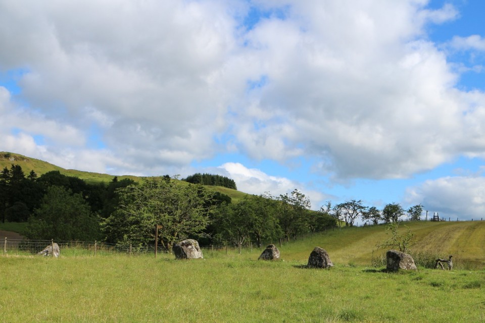
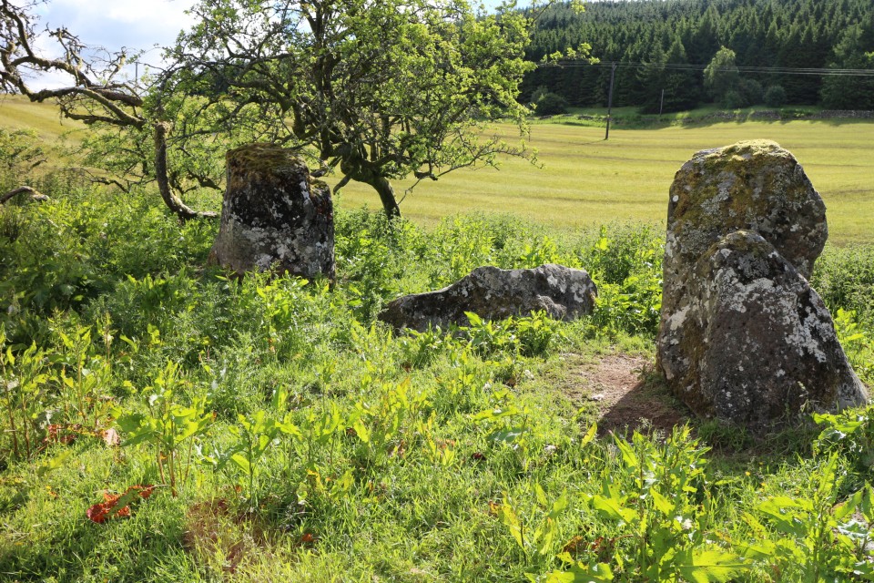
We took this trip because Littlestone wanted to take some books down to the Samye Linge Tibetan Monastery. I checked for what was in the area as far stone circles were concerned and came up with the Girdle/Loupin stone circles. We stayed at Marilyn’s Motel in Eskdalemuir which consisted of two wooden buildings decorated in Tibetan style and very comfortable, though we were slightly squashed in the smaller building. Samye Ling was a mile and a half down the road, and a place to visit just for the joyous (and slightly over decorated temple) and also a vision of ‘wedding cake’ stupas.
The landscape of hills, valleys and rivers is marred to a certain degree by industrialised forestry and yet the beauty of it all is captured as one drives along the lanes round here. The stone circles are easy enough to get to (and only about a mile from Marilyn’s) that is if you do not have a weak ankle! But glorious when you do get to them. Situated close to the White Esk river which burbles quietly over a shallow bed. This river in fact took the other half of the Girdle Stanes as it moved over the landscape through the centuries.
The story is that perhaps half the Girdle Stanes were taken by the river after which the Loupin Stanes were erected, there is supposedly a stone row joining the two circles, rather uneven, but it could also be interpreted as station stones along the way.
We are going back to this area, the Girdle stone circle is very serene.
As a matter of interest there is a prehistoric trail to take; three Iron Age forts to climb, and of course the circles and a settlement. Castle O'er looks good.
http://www.langholmwalks.co.uk/pht/sitelist.html
A Victorian interpretation!
https://archive.org/stream/langholmasitwashhysl#page/n37/mode/2up
|
Showing 1-50 of 698 posts. Most recent first | Next 50
http://northstoke.blogspot.co.uk/
|
|