Dùn Maraig, seen from the summit of Dùn View to its north.
Image credit: Les Hamilton
Dùn Maraig, seen from the summit of Dùn View to its north.

Dùn Maraig viewed from the mainland to the east at low tide.

The former causeway shows as a slightly curving line among the weed-encrusted boulders to right of centre in this photograph.

Looking along the line of the former causeway from the shore.

Walling courses at the northwest of Dùn Maraig.

Impenetrable seaweed-covered boulders below the walling courses at the northwest of Dùn Maraig.

Seen from below, the only evidence of an entrance passage to Dùn Maraig is this slight dip on the skyline above the jumble of displaced foundation blocks.

The outline of the remains of a rectangular structure are just discernable beneath a thick carpet of grass and bluebells.

A tumble of huge defensive blocks to the east of the entrance to Dun Maraig.

The causeway stretches away from Dun Maraig in a slight curve, marked by a scattering of large boulders.

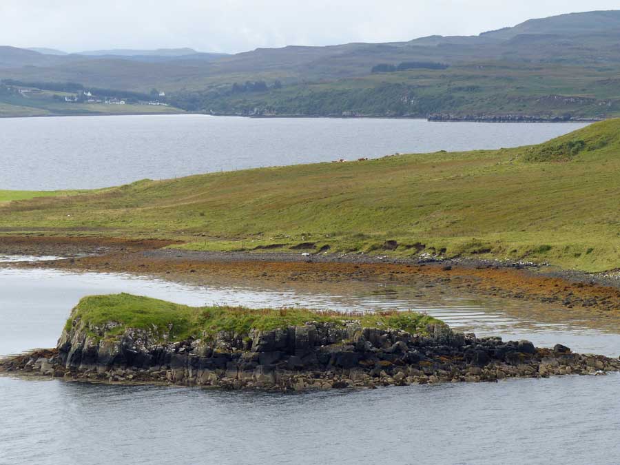
The tidal island on which stood the fort of Dun Maraig, photographed from Dun Borve.
Visited: May 25, 2017
I parked in a disused quarry half way along the Cuidrach road as the occupants of two mobile homes sat in the sunshine enjoying breakfast on this fantastic morning. The walk down to the shore then round to the neck of land to the southeast of Dùn Maraig is a pleasant two kilometres.
As luck would have it, my visit to Skye coincided with New Moon (on this actual day), which meant that neap tides were the lowest of the month. And to be sure, the islet of Dun Maraig lay absolutely high and dry—the perfect opportunity to make the short crossing and investigate the site. So, armed with two walking poles, I set out across the seaweed-encrusted boulders towards the dùn, taking what looked to be the shortest distance. The poles were a great help in keeping upright on the slippery weed, but the crossing was not difficult at all (stout boots advised, though).
Arriving at the northwest of Dùn Maraig, huge foundation blocks with the remains of four walling courses of smaller stones above them rose above me. But further progress was impossible on account of the seaweed-covered boulders that would have had to be climbed. I continued round the islet, to the southeast along a fairly easy terrace until a dip in the grassy surface above signified what was presumably the entrance to the dùn. Here it proved easy to ascend to the top of the islet’s defences. Interestingly, there is no evidence of a ‘built’ entrance passage, just the slight grassy dip through the boulders. To the east of the entrance, defences resumed in the shape of some particularly large walling blocks, now largely collapsed, hinting that this must have been an impressive fort in its heyday.
The summit of Dùn Maraig is mainly grass-covered, with a splendid bloom of bluebells at the time of my visit. Walking round the islet, it was found to be defended by cliffs the length of its north and east coasts, walling only apparently having been necessary on the lower west and south sides. Canmore refers to the remains of two oblong structures on the islet, and one was just discernable beneath the lush overgrowth of vegetation.
Dùn Maraig was originally attached to the mainland by a gently curving causeway, marked out by large boulders on each side, most of which are now long gone. This was the route I chose to make my departure, and the walking was really firm and easy, much more so than the inward route chosen, and I barely required the walking poles to negotiate it.
For those disposed for exploring off the beaten track, this is a wonderful little expedition. Just one word of warning: consult tide charts (I used data for the Isle of Lewis—just across the Minch—which was the closest I could find) and ensure you don’t become marooned by a rising tide.
Located near the southern shore of the bay at Cuidrach (a couple of kilometres south of Uig Bay) is a small island on which stand the remains of an ancient fort, Dun Maraig. Originally, the fort was connected to the land by a causeway, but this disappeared long ago. The island is, however accessible at low tide, though I did not attempt access. The accompanying photograph of the island was taken from Dun Borve, which stands beside the first bend uphill, on the road from Cuidrach House.


