|
|

|
|
Highland (Islands)
|
|
|
|
Sites/Groups in this region:
|
2 posts
9 sites Eigg |
19 posts
172 sites Isle of Skye |
1 site
Raasay |
Latest posts for Highland (Islands) |
Showing 1-10 of 1,781 posts. Most recent first | Next 10 
Vatten (Cairn(s)) — Folklore |
It is unclear why the two cairns were built together, but local folklore provides its own interpretations. One tale is that one of the mounds is the burial place of a great chief who owned the surrounding land. Each summer he went on a raiding mission with his men, bringing back gold, cattle and slaves. One summer he did not return when expected, but in the autumn the ships sailed slowly into the bay. The body of the chief was carried ashore on his men's shields to be buried in a huge grave, while in the bay below, his galley was ritually set alight.In 'Prehistoric Scotland' by Ann MacSween and Mick Sharp (1989). |
 Posted by Rhiannon
9th January 2024ce |
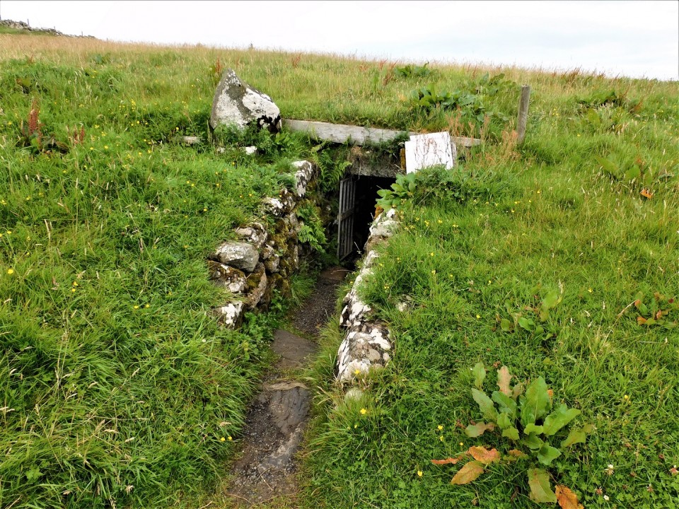
Kilvaxter (Souterrain) — Fieldnotes |
|
Taking the coastal route on the A855 from Portree to Uig we stopped to give the the souterrain at Kilvaxter another visit. It appears the entrance has narrowed as it seemed a tighter squeeze than my last visit. The only thing to add to previous fieldnotes is that the site and surrounding area, including the nut circle, needs a good tidy up if it is to pull in a fair number of visitors. Anyway, onto Uig and ferry to Lochmaddy. Visited 05/08/2023. |
24th December 2023ce |
Rubh An Dunain (Cairn(s)) — Fieldnotes |
|
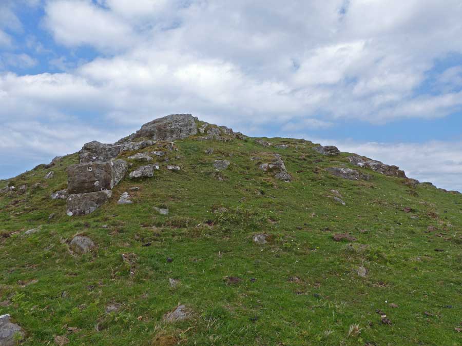
Of the four sites this one probably has the best views of the dun, chamber cairn, cave, naust / canal, loch, mountains and sea. On our visit the sea, Camas a Mhurain - Gulf of the Sea, was an astonishing colour of blue. The cairn sits at nearly 13m wide and is 1.1m tall. Lots of stonework can be seen poking through the well manicured turf, local greenkeepers do an excellent job. Decent kerbs can be seen situated around the site. Probably a lot of stones have been used in the building of the dyke which seperates the two cairns. Now we made our way back to the main track via a route suggested by a site that promotes highland treks / walkways. This led us around the west of Carn Mor, there is no path of any kind, it goes near the top of cliffs and in parts is an ankle breaker. Take the main track back, we were mightily relieved to emerge unscathed back to the track along with the dog. That site will never be used again. Apart from track malfunction everything at Rubh An Dunain was as perfect as perfect could be. Great weather, great place. Visited 04/08/2023. |
30th November 2023ce |
Rubh an Dunain (Chambered Cairn) — Fieldnotes |
|
From the dun we crossed the Viking-made canal via handily placed causeway and made our way round the sound side of Loch na h'Airde before heading north towards the cairns that are located in front of the small hill, Carn Mor. As Mr G said this is an isolated place nowadays but it once appeared to be reasonably populated with the nearby dun, medieval townships and various Nordic visitors. Now the closest people are at Glen Brittle, the most regular visitors being sheep and cows along with people making the trek to the various sites. The chambered cairn still sits at 20m wide and a good gentle tidy would reveal that a lot of it is still in place. Large slabs and some well built dry stanes remain in place. A gentle restoration would be wonderful to see but given the location, highly unlikely. The view as ever remains glorious and we're lucky that we have made it on a beautiful clear day day which seemed unlikely given the previous nights dreich stuff. Not far to the next site, a wee jump over a wall. Visited 04/08/2023. |
30th November 2023ce |
Rubh an Dunain (Broch) — Fieldnotes |
|
Following almost in Les's footsteps, diversions via a cave and the dog trying to find alternative routes, we eventually made it to the superb galleried dun at Rubh an Dunain. With A being interested in nausts, this was a superb opportunity to closely look at both, with the cairns afterwards. The Sound of Soay, Loch Brittle, The Cuillins and Loch na H'Airde along with the island of Rum provide wonderful backdrops to this lonely, but obviously not that lonely in past times, place. The dun is galleried within its large wall along with a door check, rivalling those near Tayvallich. Sadly erosion will play a role here and perhaps has done so in the past, any surrounding wall has gone. Entrance to the site is via a small climb up from the Viking canal. Turn round to see the the mountains - stunning. Visited 04/08/2023. |
13th November 2023ce |
Creag A' Chapuill (Cave / Rock Shelter) — Fieldnotes |
|
First stop on our way to the famous dun, cairns and naust was the cave at Creag A' Chapuill. Parking is available near the Glen Brittle camp site. We were lucky, a beautiful day for a wonderful walk. Discoveries have placed occupation or use of the cave around the same time as the cairns were built, finishing around the the completion of the dun. To me it had an appearance of a shop as flat topped rock at the entrance resembled a shop counter. It certainly had good views as the nearby prehistoric monuments as well as Loch na h'Airde can be seen to the west. The shop idea might be close as various pottery and later iron slag were found at the site. Also found was an oar shaped piece of wood, to me it looked like the shape of a wooden tool I'd seen used at a demonstration at Archeolink beside Oyne, sadly now closed. An interesting place. I headed south west from the path at the medieval MacAskill township, heading across a surprisingly dry valley, only a small stream to jump. The cave be seen from here so reasonably easy to find with the ascent to the site being fairly easy. However, cut across back to the main path as south of the cave is boggy when heading to the dun and cairns. Wonderful views. Visited 04/08/2023. |
6th November 2023ce |
Cille Brighde (Cairn(s)) — Fieldnotes |
|
In what has been described as an old church, the remains of a stone circle is instead the remains of a much disturbed cairn some 17m wide and 0.5m high. Parts of the cairn can be spotted as a small bank in which several kerbs still remain. The large stone may have stood or it might simply have always been there. From the standing stone at Clach Na h'Annait, I circled round Kilbride House in an anti clockwise direction, climbing one wall, then jumping the Allt Na Leth-Pheighinne stream, which by this time because of heavy rain seemed to be getting deeper and wider. Walk into the field, head straight west and look for the small trees. The site is most definitely next to edge of a former loch which I can verify is now very boggy. After a good splash around it was back over the burn to walk back up the road to the car. A bit of a 'what' if but a nice wee stop despite the dreich conditions. Visited 03/08/2023. |
29th October 2023ce |
Clach na h'annait (Standing Stone / Menhir) — Fieldnotes |
|
Parking is available just beyond the track to Ashbank, near the minor road that leaves the B8083. From there I walked towards Kilbride House and simply opened a gate to walk to the standing stone, slightly to the east. Clach na h'annait means 'Stone Of The Mother Church' and it stands at nearly 2.4m. The stone has faired much better than the church, it has long since vanished. An impressive stone with atmosphere added by low clouds and rain. Visited 03/08/2023. |
22nd September 2023ce |
An Sithean (Chambered Cairn) — Fieldnotes |
|
Mr G's meandering sheep were visiting the cairn at the same time we meandered up to the same site. Still impressive amongst some of Scotland's best and rugged scenery. There is something about driech misty days that seem to age a site, almost like in very old forests - the whole atmosphere changes. The remains of the chamber, like dodgy teeth in a kerb cairn, are still in place and the impressive width, regardless of who put it there, shows how clever the builders were - they took advantage of what was there. Happily I took more in than my last visit - playing at the 1986 Broadford Music Festival at the airstrip. A nice walk to clear the head. I've been to Skye many times since so it was nice to go back down the Elgol road. Visited 03/08/2023. |
19th September 2023ce |
Kilvaxter (Souterrain) — Images (click to view fullsize) |
|
23rd August 2023ce |
Showing 1-10 of 1,781 posts. Most recent first | Next 10