|
|

|
|
Somerset
|
|
|
|
Sites in this group:
|
1 post
Ashbridge Farm Round Barrow(s) |
15 posts
Ashen Hill Barrows Barrow / Cairn Cemetery |
5 posts
Athelney Ancient Village / Settlement / Misc. Earthwork |
|
4 posts
Avalon Marshes Ancient Village / Settlement / Misc. Earthwork |
7 posts
Barrow Hill Hillfort |
11 posts
Barrow Hill (Buckland Dinham) Long Barrow |
|
14 posts
Bats Castle Hillfort |
8 posts
Battlegore Barrow / Cairn Cemetery |
23 posts
Beacon Batch Barrow / Cairn Cemetery |
|
19 posts
Beacon Hill Round Barrow(s) |
1 post
Beechbarrow Round Barrow(s) |
2 posts
Berry Castle Enclosure |
|
4 posts
Big Tree Long Barrow Long Barrow |
3 posts
Blacker's Hill Hillfort |
1 post
Black Ball Hill Cairn Cairn(s) |
|
11 posts
Black Down (Priddy) Round Barrow(s) |
8 posts
Black Hill and Hurley Beacon Barrow / Cairn Cemetery |
3 posts
Bleary Pate Round Barrow(s) |
|
8 posts
Bossington Hill Cairn(s) |
1 post
Bracelet Cave Cave / Rock Shelter |
24 posts
Brean Down Barrow / Cairn Cemetery |
|
8 posts
Brean Down Fort Hillfort |
17 posts
Brent Knoll Hillfort |
1 post
Bristol Plain Farm Barrow / Cairn Cemetery |
|
10 posts
Burrington (Black Down) Barrow / Cairn Cemetery |
2 posts
Burrow Hill Round Barrow(s) |
10 posts
Bury Castle (Selworthy) Hillfort |
|
63 posts
Cadbury Castle (South Cadbury) Hillfort |
6 posts
Cannington Camp Hillfort |
19 posts
Castle Neroche Hillfort |
|
4 posts
Charterhouse Warren Farm Swallet Cave / Rock Shelter |
34 posts
Cheddar Gorge and Gough's Cave Cave / Rock Shelter |
2 posts
Chewton Mendip barrows Barrow / Cairn Cemetery |
|
1 post
Cock-Crow Stone Natural Rock Feature |
1 post
Cothelstone Hill Round Barrow(s) |
3 posts
Creech Hill Hillfort |
|
1 post
Curdon Wood Camp Enclosure |
2 posts
Daw’s Castle Cliff Fort |
16 posts
The Devil's Bed and Bolster Long Barrow |
|
12 posts
The Devil's Stone Standing Stones |
2 posts
Devil's Stone (Luckwell Bridge) Natural Rock Feature |
6 posts
Dowsborough Hillfort |
|
1 post
Drove Cottage Henge Henge |
2 posts
Dundon Beacon Round Barrow(s) |
3 posts
Dundon Hill Hillfort |
|
1 post
Eastwater Farm Round Barrow(s) |
13 posts
Ebbor Gorge Cave / Rock Shelter |
1 post
Elworthy Barrow Round Barrow(s) |
|
3 posts
Elworthy Barrows Hillfort |
3 posts
67 sites Exmoor (Somerset) Region |
1 post
Fairy Cave Cave / Rock Shelter |
|
1 post
Forge Barrow Round Barrow(s) |
14 posts
Fromefield Long Barrow |
3 posts
Furzebury Brake Hillfort |
|
4 posts
Gallax Hill Ancient Village / Settlement / Misc. Earthwork |
5 posts
Giant's Grave (Holcombe) Long Barrow |
4 posts
Glastonbury Lake Village Ancient Village / Settlement / Misc. Earthwork |
|
79 posts
Glastonbury Tor Sacred Hill |
8 posts
Gorsey Bigbury Henge |
3 posts
Great Hill (Quantock Hills) Cairn(s) |
|
25 posts
Hamdon Hill Hillfort |
1 post
Harptree Barrows Round Barrow(s) |
1 post
Hazle Barrow Round Barrow(s) |
|
1 post
Hole Ground Ancient Village / Settlement / Misc. Earthwork |
1 post
Home Farm Cottage Round Barrow(s) |
2 posts
Huish Champflower Barrow Round Barrow(s) |
|
3 posts
Hurdle Stone Natural Rock Feature |
2 posts
Kenwalch's Castle Hillfort |
3 posts
Kingsdown Camp Enclosure |
|
2 posts
King's Castle Ancient Village / Settlement / Misc. Earthwork |
1 post
King Down Farm Barrow / Cairn Cemetery |
1 post
Knackers Hole Cairn Cairn(s) |
|
2 posts
Leather Barrow Round Barrow(s) |
3 posts
The Long Stone Standing Stone / Menhir |
1 post
Lydeard Hill Round Barrow(s) |
|
15 posts
Maesbury Castle Hillfort |
1 post
Meare Lake Villages Ancient Village / Settlement / Misc. Earthwork |
1 post
Miner's Arms Inn Round Barrow(s) |
|
1 post
Moor View Round Barrow(s) |
22 posts
Murtry Hill Long Barrow |
1 post
Naked Boy Stone Standing Stone / Menhir |
|
6 posts
Norton Camp (Somerset) Hillfort |
6 posts
Pen Hill Long Barrow |
10 posts
Pool Farm Cist Cup and Ring Marks / Rock Art |
|
1 post
Priddy 51 Long Barrow |
22 posts
Priddy Circles Henge |
3 posts
Priddy Henges (incomplete 4th circle) Henge |
|
1 post
Priddy Hill Long Barrow |
3 posts
Priddy Long Barrow Long Barrow |
27 posts
Priddy Nine Barrows Barrow / Cairn Cemetery |
|
1 post
Ralegh’s Cross Barrow Round Barrow(s) |
5 posts
Read's Cavern Cave / Rock Shelter |
2 posts
Redhill Farm and Blackwell Tyning Round Barrow(s) |
|
6 posts
Rhino Rift Barrow Round Barrow(s) |
3 posts
River Frome Barrow Round Barrow(s) |
1 post
River Yeo Stone Standing Stone / Menhir |
|
10 posts
Robin Hood's Butts North (Otterford) Barrow / Cairn Cemetery |
23 posts
Robin Hood's Butts South (Otterford) Round Barrow(s) |
4 posts
Roddenbury Hill Hillfort |
|
2 posts
Rowbarrow Round Barrow(s) |
1 post
Rowberrow Cavern Cave / Rock Shelter |
1 post
Rowberrow Farm Round Barrow(s) |
|
7 posts
Rowberrow Warren Cairn(s) |
2 posts
Ruborough Camp Hillfort |
10 posts
Selworthy Beacon Barrow / Cairn Cemetery |
|
1 post
Shave Farm Standing Stone / Menhir |
6 posts
Small Down Barrow / Cairn Cemetery |
1 post
Southfield Farm Barrow / Cairn Cemetery |
|
1 post
Stow Barrow Round Barrow(s) |
1 post
St Lawrence Church Round Barrow(s) |
2 posts
Swayne's Jumps Standing Stones |
|
5 posts
The Sweet Track Ancient Trackway |
1 post
Tedbury Camp Hillfort |
1 post
Three Tuns Farm Round Barrow(s) |
|
1 post
Tom Tivey's Hole Cave / Rock Shelter |
1 post
Totty Pot Cave / Rock Shelter |
9 posts
Trendle Ring Hillfort |
|
1 post
Triple H Cave Cave / Rock Shelter |
1 post
Tripp Barrow Round Barrow(s) |
7 posts
Triscombe Stone Standing Stone / Menhir |
|
1 post
Tyning's Farm Barrow / Cairn Cemetery |
2 posts
Wadbury Camp Hillfort |
2 posts
Weacombe Hill Round Barrow(s) |
|
7 posts
Wearyall Hill Sacred Hill |
1 post
Wellington Farm Round Barrow(s) |
7 posts
Wells Museum Holed Stone |
|
5 posts
West Hill (Quantock Hills) Cairn(s) |
5 posts
Whitestown Farm Barrow / Cairn Cemetery |
3 posts
Whitnell Corner Barrow / Cairn Cemetery |
|
1 post
Whitstone Standing Stone / Menhir |
22 posts
Wick Barrow Round Barrow(s) |
11 posts
Wills Neck Round Barrow(s) |
|
7 posts
Wilmot's Pool Round Barrow(s) |
11 posts
The Wimblestone Standing Stone / Menhir |
4 posts
Wimble Toot Round Barrow(s) |
|
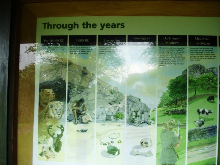
Windmill Hill (Glastonbury)
Artificial Mound
|
2 posts
Wiveliscombe Barrow Round Barrow(s) |
14 posts
Wookey Hole Cave / Rock Shelter |
|
1 post
Yonder Cross Stone Standing Stone / Menhir |
Sites of disputed antiquity:
|
2 posts
Ashbrittle Yew Round Barrow(s) |
8 posts
Chalice Well Sacred Well |
26 posts
Deerleap Stones Standing Stones |
|
3 posts
Devil's Stone (Staple Fitzpaine) Standing Stone / Menhir |
15 posts
Faulkland Standing Stones |
3 posts
Ponter's Ball Ancient Village / Settlement / Misc. Earthwork |
News |
|
Mendip Hills team gets conservation cash boostThe team that looks after the landscape of the Mendip Hills has been given more than £200,000 to help with its conservation. The Heritage Lottery Fund money will be spent on teaching people about the history and archaeology of the Black Down and Burrington Commons... continues... |
 Posted by moss
18th January 2013ce Edited 3rd April 2016ce |
Oldest open-air cemetery in the UK foundSomerset was the site of the UK's oldest open-air cemetery, the county council says. Recent radiocarbon dating of two skulls found at a sand quarry in Greylake nature reserve near Middlezoy in 1928 revealed them to be 10,000 years old... continues... |
 Posted by goffik
26th July 2011ce |
|
Heritage Police to guard ancient sites Posted on Facebook by http://www.digitaldigging.co.uk/index.html Heritage police to guard historic icons in Somerset, Wiltshire and Gloucestershire - will also guard against illegal metal detecting. http://www.thisissomerset.co.uk/news/Heritage-police-guard-icons/article-3212734-detail/article.html |
 Posted by tjj
12th February 2011ce |
Combing the Mendips for historic treasuresFrom The Weston & Somerset Mercury: A TEAM of archaeologists will begin a four year hunt for hidden treasures on the Mendip Hills soon. A dozen English Heritage specialists will use the latest aerial scanning technology as well as field surveys and other traditional archaeological techniques to look for new finds... continues... |
 Posted by baza
21st July 2006ce |
Bronze Age hoard from Silk Mills BridgeArchaeologists are currently studying the hoard found at Silk Mills Bridge near Taunton in the summer, before the items go on public display. "Steven Membery, archaeologist for Somerset County Council, said of the site: "It appears to be an island in a large river. It was used seasonally probably for hunting ducks and fish... continues... |
 Posted by Rhiannon
3rd January 2006ce Edited 3rd January 2006ce |
Wetland sites being lost through drainageA study has highlighted how rural development and drainage for agriculture in the Somerset levels has badly damaged nationally important archaeological sites. When ground water levels drop in the summer, the waterlogged remains dry out: current farming methods don't leave enough water inthe peat to protect them... continues... |
Posted by Rhiannon 10th October 2005ce Edited 10th October 2005ce |
|
6.500yr old causeway and fish weir found nr Bridgewater, Somerset. Workers digging a new rubbish tip at Walpole nr Bridgewater have found the remains of an ancient causeway and fish weir. Archaeologist Richard Brunning has provisionally dated them to 4.500 BCE. More here... |
 Posted by jimit
13th July 2005ce Edited 15th February 2006ce |
Iron Age shoe unearthed at quarryA shoe believed to be 2,000 years old has been dug up at a Somerset quarry. The Iron Age relic was found in a hollowed tree trunk set into the ground at Whiteball Quarry, near Wellington... continues... |
Posted by goffik 10th May 2005ce |
Cave Network Found Under Car ParkFrom - http://news.bbc.co.uk/1/hi/england/bristol/3550105.stm A group of potholers stopped from exploring because of the foot-and-mouth epidemic, found a network of caves under the car park of their local pub... continues... |
 Posted by pure joy
20th March 2004ce Edited 25th March 2004ce |
Prehistoric Axe Found in a Garden in SomersetA 5,000-year-old flint axe head has been found in a garden in Somerset (England). Andrew Witts made the rare prehistoric discovery while landscaping his garden at Creech St Michael near Taunton. Mr Witts said: "I knew I had found something unusual when I noticed the object had a polished surface, but I never thought it would be that... continues... |
15th March 2004ce Edited 15th March 2004ce |
Homes Refused on Prehistoric SiteThe site of archaeological remains which are thought to date back thousands of years has been saved from development. An area occupied by a Scheduled Ancient Monument was at risk of being turned into a small housing estate on the edge of Highbridge and West Huntspill in Somerset... continues... |
17th December 2003ce Edited 17th December 2003ce |
Links |
|
The Lost Stone Circles of North Somerset |
Posted by moss 17th December 2014ce |
UBSS - The Long Barrows and Long Mounds of West MendipLewis,J., 2009. The long barrows and long mounds of West Mendip. UBSS Proceedings, 24(3) , pp 187-206 Abstract: This article considers the evidence for Early Neolithic long barrow construction on the West Mendip plateau, Somerset. It highlights the difficulties in assigning long mounds a classification on surface evidence alone and discusses a range of earthworks which have been confused with long barrows. Eight possible long barrows are identified and their individual and group characteristics are explored and compared with national trends. Gaps in the local distribution of these monuments are assessed and it is suggested that areas of absence might have been occupied by woodland during the Neolithic. The relationship between long barrows and later round barrows is also considered. |
 Posted by juamei
21st January 2014ce |
Charterhouse Environs Research TeamIntroduction to the 'Chert' index to the drawings and sketches of the Rev. John Skinner A great antiquarian! |
Posted by moss 18th December 2012ce Edited 19th December 2012ce |
YouTubeShort video from the Museum of Somerset showing some of the gold objects found in the county. Steve Minnitt presents a torc found near Yeovil, an amazingly intricate and fine ring-shaped Thing, and the 17 gold objects untangled from the hoard buried at Priddy. |
Posted by Rhiannon 12th March 2011ce |
The Bath and Camerton Archaeological Society (BACAS).Website includes history of the society, along with excursions, lectures, open days and events |
 Posted by Chance
10th July 2010ce Edited 10th July 2010ce |
Wells & Mendip Museum websiteSite includes finds, details and future events of the Wells Natural History and Archaeological Society. |
Posted by Chance 10th July 2010ce Edited 3rd April 2016ce |
Somerset Historic Environment RecordAn excellent resourse for finding details of sites in Somerset. |
Posted by jimit 14th November 2003ce |
Latest posts for Somerset |
Showing 1-10 of 1,160 posts. Most recent first | Next 10 
Wick Barrow (Round Barrow(s)) — Folklore |
A comeback to ward off the gremlins.From the Western Daily Press, 6th January 1982. |
Posted by Rhiannon 6th January 2024ce |
Wimble Toot (Round Barrow(s)) — Folklore |
Babcary Tout or Wimble Toot.In the Taunton Courier, 30th October 1937. |
Posted by Rhiannon 6th January 2024ce |
Priddy Nine Barrows (Barrow / Cairn Cemetery) — Folklore |
I wonder if you can throw any light on the following experience I had some 12 or 14 years ago? I had taken my family on Mendip Top, somewhere near Castle of Comfort, and we were picnicking, having boiled our kettle with pine chips, I remember, when a roughish man, driving a rougher horse, attached to a vehicle, half cart, half trap, harness mainly rope, made me feel a foot taller by suddenly asking, 'Would you like to rent a couple of hundred acres of shooting?'In the Western Daily Press, 22nd August 1936. |
Posted by Rhiannon 15th June 2023ce |
Dowsborough (Hillfort) — Folklore |
A further spooky story connected with the vicinity of the camp.A Quantock Hills Ghost Story.'West Somerset Free Press', 18th July 1891. |
Posted by Rhiannon 11th June 2023ce |
Cannington Camp (Hillfort) — Folklore |
Miss Lock may be interested to know that the Rev. C.W. Whistler, a former vicar of Stockland, Bristol, and one of the greatest authorities upon the traditions and folk-lore of the Quantock country, recorded the local tradition that Rodway Hill, between Cannington village and the "Park" near Combwich, is so named from the rood erected on it to protect villagers from the Devil's hunt. He recorded, too, the story of a man who was said to have met a great black spectral hound on this hill, and that it brushed up against him in passing and that he was paralysed ever after.Mentioned in 'Local Notes and Queries' in the Taunton Courier, 1st January 1936. |
Posted by Rhiannon 11th June 2023ce |
Wick Barrow (Round Barrow(s)) — Images (click to view fullsize) |
|
Posted by Ike2 5th May 2023ce |
Showing 1-10 of 1,160 posts. Most recent first | Next 10