|
|

|
|
Priddy CirclesHenge
|
|
|
|
News |
|
English Heritage update on the Priddy repairsPRIDDY CIRCLE 1 – STATEMENT ON ARCHAEOLOGICAL MITIGATION AND REINSTATEMENT BACKGROUND In May 2011, large-scale unauthorised damage took place on one of the four Priddy Circles, a group of large, circular earthworks of prehistoric date which are protected as Scheduled Monuments... continues... |
 Posted by juamei
9th January 2014ce Edited 9th January 2014ce |
Priddy Stone Circles vandal, 73, ordered to pay £10,000A 73-year-old man who vandalised a 5,000-year-old stone monument has been ordered to pay £10,000. Roger Penny, of Chewton Mendip, appeared before Taunton Crown Court after he damaged one of the Priddy Stone Circles, which is on his land... continues... |
 Posted by moss
26th October 2012ce Edited 26th October 2012ce |
Priddy Circles case delayedSentencing of the man responsible for the destruction of one of the Priddy Circles, an ancient monument high on the Mendip hills has been delayed... continues... |
Posted by Mustard 4th June 2012ce |
Somerset man charged with damaging Priddy CirclesA man from Somerset is to appear in court charged with damaging a prehistoric monument near Wells. Damage was done to a section of the Priddy Circles, which is made up of four large Neolithic circular henges, at some point in May or June last year... continues... |
Posted by Mustard 4th April 2012ce |
Damage prosecution decision imminentFrom thisissomerset: Investigations into the damage to Priddy Circles on the Mendip hills have been completed... continues... |
 Posted by baza
10th March 2012ce Edited 10th March 2012ce |
Outrage as Neolithic Monument bulldozed flatReports began to circulate in early June concerning damage to one of a series of four remarkable Neolithic monuments in Somerset, southwest England. However, the scale of the damage to the Priddy Circles is only now being fully appreciated... continues... |
Posted by Ubik 18th July 2011ce |
Images (click to view fullsize) |
|
|
Fieldnotes |
|
|
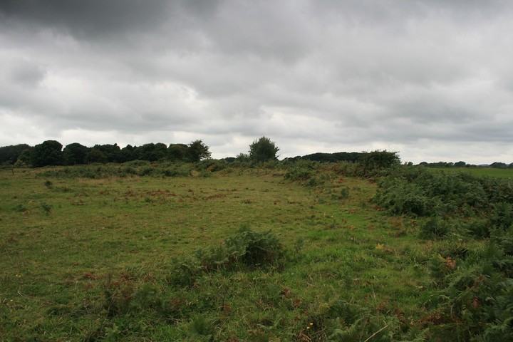
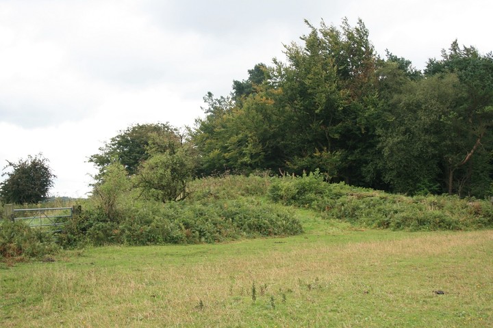
Visited 7.9.13 With all the attention this site (quite rightly) has received lately due to the unnecessary damage caused I just had to stop off and have a look for myself. For a B road the B3135 was very busy but we managed to pull over in front of the metal field gate which gives access to the field where the southern circle is. There is no public right of way into the field and given the recent publicity I would imagine that visitors would be made less than welcome. However, I decided the best approach would be to try to get some height and see what can be seen? I climbed to the top of the gate and balanced myself as I looked for any signs of damage etc. On the plus side I couldn’t see any bulldozer damage but on the negative side I couldn’t see much of any banking either – except for a section on the north eastern side? The field is quite overgrown and it is difficult to tell what is what. If this was the section that has been destroyed it would explain why there was little to see and nature has covered up signs of destruction. Either that or the section I was looking at had already been ploughed out / eroded. Unfortunately, looking at aerial photos I think I was viewing the destroyed section? Either way there is sadly very little left to be seen of the southern circle. P.S. I forgot to look for the ‘tumulus’ marked on my O/S map which is located right next to the road, nearer the house. A modern stone wall has been built along this section of road so it may not be possible to see from the road? |
Posted by CARL 10th September 2013ce |
|
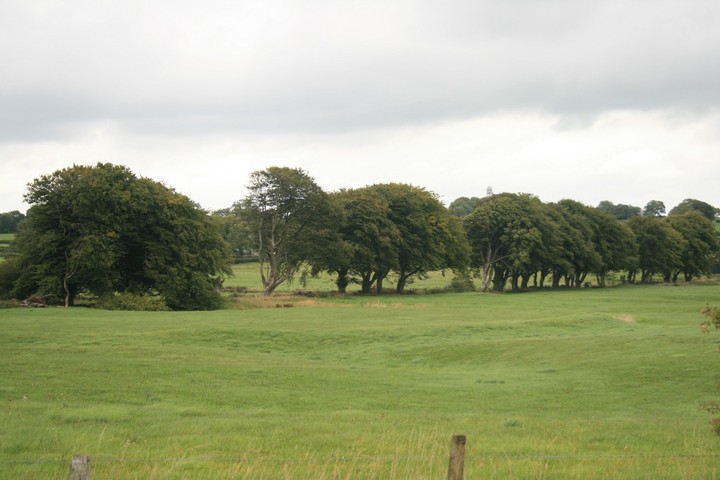
We parked by the gate, but didnt block it and quickly jumped it, here is a lost treasure if ever there was one. The southern henge, once the entire curve has been noted it can be seen to be really huge, higher in some places and flattened in others, its entirety covered in ferns and brambles, what hides the henge from us hides us from the farmer/huntsmen. Swings and roundabouts. Standing on the bank of the southern henge and looking into the next field the central faded henge can be seen but a fence climb seperates us from a walkaround of it and its other neighbour, but it can still be seen in the field through the trees. The incomplete henge can be seen from the other north/south road, the arc can be seen by standing on the gate or possibly by going through it. |
 Posted by postman
11th November 2010ce |
Folklore |
|
Here's an alternative name for the circles I'd not come across before.The range is still called "Priddy Nine Barrows." They stand out boldly on the ridge of the hill as you look towards Wells on the road thither from East and West Harptree [...]From the Archaeological Journal, v16 (1859) p150 (in the Rev. Harry M Scarth's Account of the Investigation of Barrows). |
 Posted by Rhiannon
11th June 2010ce |
| A follow up on Rhiannon story of Jesus in Priddy. I heard a story many years ago that the local people of Priddy would use the phrase, " As sure as the Lord walked in Priddy". This would be used in the same way as someone today might use the phrase " Is the pope Catholic?". |
Posted by vulcan 13th August 2005ce |
This is quite peculiar. There is a tradition in Priddy that Jesus visited the tin mines in Cornwall with his uncle, Joseph of Arimathea ("Uncle Joe" probably - no, I'm making that bit up) and then came up to the lead mines at Priddy. Our Lord when a boy came voyaging with a sailor uncle to Britain. Their trading ship put in at Watchet, and from there He walked across the Quantocks to Bridgwater where He boarded a punt and crossed the lakes and marshes to the foot of Mendip, ending his journey high up at Priddy. Here, say the miners, He walked and talked and worked with them a happy while, and then, loaded with Somerset gear, He went back to Nazareth.This is in Ruth Tongue's 'Folklore of Somerset' (County Folklore v8), and she heard it locally throughout the first half of the twentieth century. I guess it's a story about trading metals with far away places to the South.. hm - could this really be a folk memory of actual trading? A similar story - but necessarily about pre-Jesus times (mentioned by S Toulson in her 'Moors of the Southwest v1' 1983) says that the lead from the Mendip mines was shipped to Jerusalem to build Solomon's temple. |
Posted by Rhiannon 2nd August 2005ce Edited 16th August 2005ce |
Miscellaneous |
|
|
Southernmost of the four Priddy circles. Excavations in 1956-9 in the NW quadrant revealed that the bank had a stone core with a ring of post-holes on each side. The posts had been of 8" diameter and about 10ft high with stakes between them, apparently erected prior to the ditch, whose upcast was added to the bank probably leaving the posts projecting at least 4-6ft above the earth top. A causewayed entrance was proved for the circle in the NNE sector. Central area was devoid of any structure and no finds were made. {1} Belongs to the secondary Neolithic and fall into the Henge group of monuments, class 2. Banks average 1m high and the ditch is 0.4m deep. {4} Bank at best 7m wide and nearly 2m high, interior area flat and about 1m above the surrounding fields. Divided ownership marked by stone wall running NNW-SSE. Part on the W has never been ploughed but is somewhat cut about by old mine workings. On the S the bank is not well preserved. On the E the interior of the circle has been ploughed at some time but the bank is untouched. Some evidence of the stone construction of the bank is visible at some points. Few thorn and gorse bushes on the E side. {5} Ploughing of centre and surrounding area but not bank in 1984-5. {6} The interior of the E part of the circle has been ploughed again this spring. One quite large stone has been disinterred and added to the bank. {7} Many of the surface depressions in and around the Priddy Circles are natural sinkholes, not mine workings as had been assumed. Unsatisfactory ground conditions (the ground remained liable to subsidence) may have been one of the factors that led to the abandonment of the whole ceremonial site before the circles were completed. {10} Scheduling revised with new national number on 31.1.1997 (was Somerset 119). {11} See PRN 90072 for inconclusive geophysical survey and discussion. {12} The monument is basically stable under pasture but there are areas of scrub, nettle, bracken etc growth on the banks. {13} See PRNs 24043, 24045, 24046 for the other three Priddy circles. {14} References: 1 Excavation report - PUBSS Taylor, C and Tratman, E.K 1956 "The Priddy Circles..." vol 8(1), 7-17 2 Mention - PUBSS 1960 vol 9(2), 64 3 Excavation report - PUBSS Tratman, E.K 1966 "The Priddy...Henge Monument" vol 11(2), 97-125 4 Detailed records - Ordnance Survey Archaeology Division 1966 ST55SW4 SCPD 5 Detailed records - HBMC Field Monument Wardens report SCPD 6 Personal communication - Dennison, E SCPD 12.09.85 7 Detailed records - HBMC Field Monument Wardens report SCPD 8 Aerial photographs - Slide SCPD 2.040.0004 9 Map - HBMC Field Monument Wardens report SCPD 10 Detailed records - Stanton, WI "Natural sinkholes...Priddy Circles..." PUBSS 17(3) (1986), 355-8 11 Correspondence - EH to SCC (7.2.1997) in HER files 12 Personal communication - Webster, CJ SMRO (14/12/1998) 13 Site visit report - Graham, A. EH field Monument Warden (25/7/2000) report in HER files 14 Personal communication - Matthew Nicholas, SCC (7/7/2003) Record created by: Ed Dennison in September 1985 © Copyright Somerset County Council 2003 With thanks to the Somerset Museums Service for the link to this information. |
 Posted by jimit
14th November 2003ce |
|
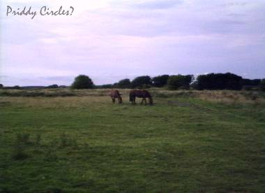
Out here on the Mendips there are four large henges, roughly in a north-south line. The southernmost was partly excavated in the 1960s and they discovered the bank was made of earth, turf and stones, supported both sides by posts and stakes. The funnel-shaped entrance was outlined by posts. They didn't find anything actually within the henge - no structural features and no little artifacts from the time of its construction: a deliberately 'clean' area? A pollen analysis showed that the land was grassy when the henge was being built, rather than it still being surrounded by woodland. What's left is probably best appreciated from the air - I saw a local tv programme recently in which they were flying over the area, and the size of the henges was really impressive. (A bit bigger than vulcan's photographed circle). One would be impressive enough - but why did they need four (or more)? It's all so very mysterious. |
Posted by Rhiannon 27th February 2003ce Edited 13th August 2005ce |
Links |
|
Academia.edu - 2011 - New Excavations at Priddy Circle I, Mendip Hills, Somerset.Report on the 2008 excavations at the Priddy circles by Lewis, J & Mullin, D |
Posted by juamei 8th January 2014ce |
Online petition to stop people damaging heritage sitesThis has been posted extensively on Facebook and am surprised not to see it here. Most TMA members have signed already but just in case you missed it .... please sign. Thank you |
 Posted by tjj
21st July 2011ce Edited 21st July 2011ce |
The Prehistoric SocietyThe Prehistoric Society's newsletter from April 2010 has a short article about the recent excavations in circle 1 (accompanied by aerial photo by Pete Glastonbury) and results of the carbon dating made. It seems that circle 1, at least, is Neolithic - because of the site's distinct unusualness, even this had been disputed before. But there are still lots of questions about how the site developed and whether all the henges were made at the same time. |
Posted by Rhiannon 11th June 2010ce |
The Megalithic portal and Megalith MapAerial Photo of three of the henges. The unfinished henge is not seen. |
Posted by vulcan 27th July 2004ce Edited 27th July 2004ce |
Somerset Historic Environment Record |
Posted by jimit 14th November 2003ce |