This site is of disputed antiquity. If you have any information that could help clarify this site's authenticity, please post below or leave a post in the forum.
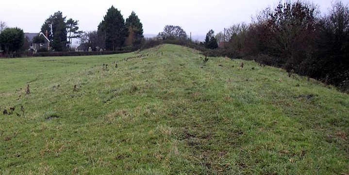
[ST 53013730 - ST 53463822] Ponter's Ball [G.T.] (1) This is a linear earthwork about 15ft. high and ditched on the east. It is a five-eights mile long, and runs NNE-SSW across the high ground between Hearty Moor (ST 5339) and Kennard Moor (ST 5236), both formerly swamps. It probably formed a continuous defensive barrier with the earthwork 'New Ditch, (of similar construction and orientation), some three miles to the SW [ST 53 SW 20.] Bulleid put a section across Ponter's Ball in 1909, but found very little except a few potsherds; some fragments, from the old turf line under the bank, were regarded by Sir Hercules Read as Bronze Age: others, deep in the ditch, were thought to be Glastonbury Lake Village type, but as no sherd was decorated this classification is tentative. Pottery in Taunton Museum. (2-4)
This earthwork is similar to New Ditch but of more formidable construction. The gap through which the modern road passes is staggered and appears to be original; to the north of it the ditch is well defined, but to the south has been obscured by a modern hedge and drainage ditch. Radford suggests Ponter's Ball as part of a great Celtic sanctuary: probably 3rd.c. B.C.
The pottery from here is still in Taunton Museum (ACC.3434). surveyed at 1:2500. (5)
Ponter's Ball is possibly sub-Roman and connected with the DA occupation on Glastonbury Tor (ST 53 NW 4).
Excavation in 1970 appears to date Ponters Ball, at least at the point examined, to the 12th century or later. (6-7)
Ponter's Ball is a bit mysterious - it seems people can't agree on how old it is, or what it was for. But it's certainly not inconspicuous: it's a linear earthwork about 15 feet high, and you drive through an (apparently original) gap in it when travelling from Glastonbury to Shepton Mallet. To add to it there's a ditch on the Shepton Mallet side. As for the name - perhaps someone reading this knows where it derives from?
The Somerset Historical Environment Record adds that both ends of the earthwork are at the 32ft contour- perhaps it was constructed when the water of the sea/marsh was at this height (though it could be longer, with its ends buried by later alluvial deposits). If really does end where it seems to "it can hardly be regarded as a defensive work like the rampart of a hillfort - the area defended is too large, the earthwork too long and would be easily bypassed." So they suggest it must be seen as territorial boundary (political or for stock protection), or even a religious boundary marking a prehistoric sacred area. The latter being much more romantic of course, but let's not get too carried away.

 Posted by Chance
 Posted by Rhiannon