|
|

|
|
The Devil's Bed and BolsterLong Barrow
|
||||||||||||||||||||||||
|
|
|
Images (click to view fullsize) |
|
|
Fieldnotes |
|
|
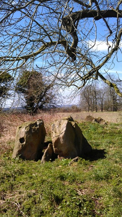
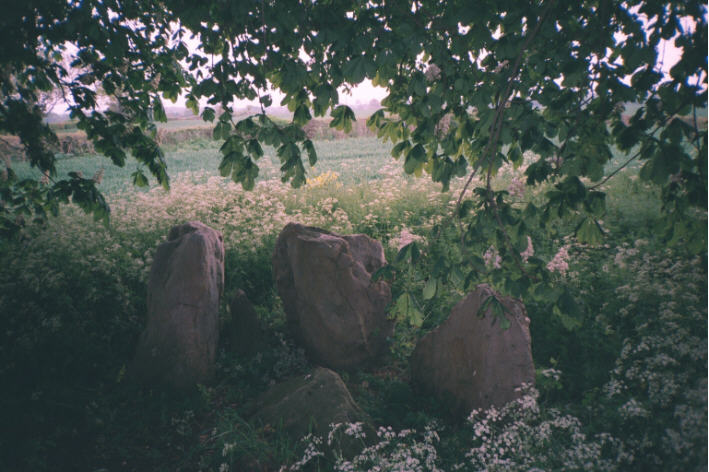
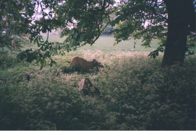
Visited 6th April 2013 Following the fine directions given by previous contributors, and the particularly useful link provided by Rhiannon, I managed to find this place no problem, and worked it into a visit on a round trip from Glastonbury taking in both Stoney Littleton and the Faulkland standing stones first. As suggested parking at The Bell Inn (right next to the A361 Frome Road at the village of Rode) is by far the best plan, and the public footpath is easily accessible just across the road. Once over the first stile and into the fields proper you soon see the copses of trees on the rise ahead, to which you have to aim. The fields up to the copses were currently fallow, but clear paths around their edges allowed me not to get my feet too muddy. Gates were all open and access was easy, with only the occassional distant report of a shotgun giving me a vague sense of unease lest I become unwitting cannon fodder for a trigger happy farmer. As I head across the fields I disturb a pair of deer grazing at the newly emerging shoots, and we both freeze, staring wide eyed at each other for a moment, before they turn and flee from this noisy interloper. Soon I'm at the barrow, huddled amongst the trees, the outline of the monument clearly visible since most of the vegetation has either died back in the harsh winter, or else been cropped by the fiendly neighbourhood deer. As I take in the whole of the monument it almost looks like a cutaway diagram of a barrow, the footings of the mound still clearly visible, the entrance portal stones standing proud, and a thick stone defining the end of the barrow (presumably the Devil likes to prop his feet up when in bed). I crouch down to take a closer look at the portal stones, getting a few nettle stings in the process, but noticing what could possibly be three cupmarks on the interior facing of the stone. Once again I curse the fact that I've left the camera at home, and so am forced to take photo's with the phone (which singularly fails to provide a decent picture of the cupmarks), oh well just an excuse to return I guess. As I sit quietly here a buzzard swoops in low and lands in the tree next to me, and I'll echo Rhiannon's thoughts, it is lovely here, and the sort of place you could spend hours. It seems as if few people visit, there was certainly no evidence of any rubbish or offerings at the site, and it feels like this is the Severn-Cotswold barrows best kept secret. Often it is some of these lesser known places that retain a more tangible atmosphere. I notice that the village church seems to be in a direct line with the barrow, which along with attributing the stones to the Devil, is one of those terribly insecure Christian gestures, to defame any other alternative beliefs. Well if the devil has all the best tunes, then he also seems to have the best places, as I'd much rather be here in this magical place than in the cold dour surroundings of the local church. With that thought I head back to The Bell, to finish off a site visit in the best possible way, with a nice pint. |
7th April 2013ce Edited 7th April 2013ce |
|
Visited today, 10/11/10 An exquisite day weather-wise, the final day (perhaps) in the summer's 'Cotswold-Severn long barrows Tour'. It is my friend Ravensroost who I must thank for providing the transport, maps and often much of the research too. In the village of Rode we parked the car in The Bell pub carpark before setting off over the fields; although waymarked with stiles we did in fact have to crawl under a barbed wire fence (found an alternative and much easier way back). Defra signs on a couple of fenceposts marking out route of a walk. The barrow itself was a complete surprise - I knew nothing about it until today. The large stones are pale yellow limestone (Bath stone perhaps) I thought I saw some white quartz in one of them. Although we were not conscious of walking uphill when we looked around we could see we were on higher ground - panoramic views. A great start to the day before carrying on to Stony Littleton long barrow. |
 Posted by tjj
10th November 2010ce Edited 10th November 2010ce |
|
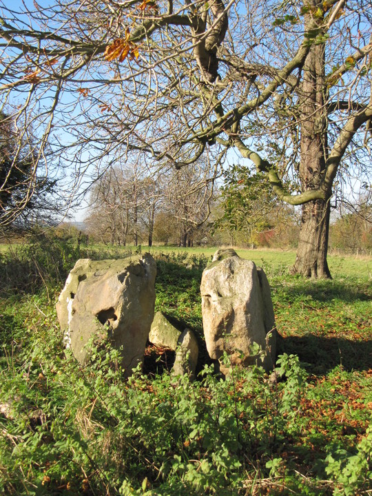
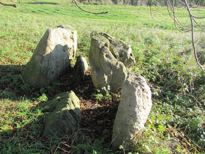
Visited 15.5.10. I had quite a bit of difficulty finding this one! As already stated, park at the Bell Inn carpark and immediately opposite is a public footpath sign and a wooden stile. Climb over the stile and follow the path over the next two wooden stiles. You will then need to cross a field and you will see a barn in the next field over - head for the barn. When you get to the corner of the field there is another wooden stile and next to it a metal gate. I looked over the stile and couldn't see any obvious path leading to the top of the hill where the stones are. (At this point if you look up at the brow of the hill you will see two small groups of trees - the stones are under the grouping to the left). So instead I climbed over the metal gate and headed diagonally across the field to the top left hand corner. I then followed the hedge until I came to the far group of trees. WARNING - this involves crossing two barbed wire fences and is not a public right of way. Then all you have to do is cross one more barbed wire fence to get into the trees and the stones are right in front of you! I counted 3 standing and 3 fallen stones. This is a lovely site and the large horsechestnut trees seem to form a protective cannopy over the stones. Very pretty in the late afternoon sunshine. Judging by the amount of nettles and shrubs it didn't look like anyone had visited this site for quite a while? It took 20 minutes to walk from the car park to the stones. If you can follow Rhiannon's directions I would suggest you do - it HAS to be easier than the way I went!! (also more legal) |
Posted by CARL 17th May 2010ce |
|
It's really very nice here. I've put off a visit for a long time because I wasn't sure about the access: it looks like one of those sly long dashes from a footpath, with the potential of shotgun pellets in the rear. However, fear not, because the local farmer(s) make the footpaths very clear, and there is actually a permissive bridleway to the barrow (from ST810532). What nice people. To me, the obvious thing in the landscape as I sat at the middle of the barrow, was Cley Hill on the sw-ish horizon. Of course, certain modern features do tend to make you look this way (the chestnut trees and the hedge behind you, the field margin to the left all block the view), so it could be irrelevant, but it didn't feel it. The stones are a soft orangey pink, flat, and pocked with tiny holes on their narrow edges. The Countryside Stewardship notice about the path mentions 'nine stones' but there are certainly more than nine. I think the atmosphere would make it easy to stay hours here.Looking for more information on the web, I see there's supposed to be a 'geocache' here. Well if I'd known (because the site was beautifully litter free on the surface) I'd have dug it up and blown it to smithereens. So that's something to do next time. Miserable, unappreciative dimwits. AND DO YOU KNOW WHAT REALLY MAKES ME CROSS?? The git who left it there copied MY cheesy phrase from this website. http://www.geocaching.com/seek/cache_details.aspx?guid=07f8c21b-bcc6-4edb-ac19-91a47a85eb80 It makes you want to give up doesn't it. TMA is surely an attempt to make people value their environment and prehistory. What can you do if some people use that information for making a mess of the place? The box apparently contains golf tees and 'dinos' and all sorts of shite. Why do people leave this 21st century detritus at these special places? |
 Posted by Rhiannon
14th September 2007ce Edited 26th September 2007ce |
| The best place to park is in the Bell Inn carpark,opposite is a public footpath,make for the second copse on the hill the stones are in the middle.Afterwards retire to the pub for refreshments. |
 Posted by hamish
12th August 2002ce |
Folklore |
|
|
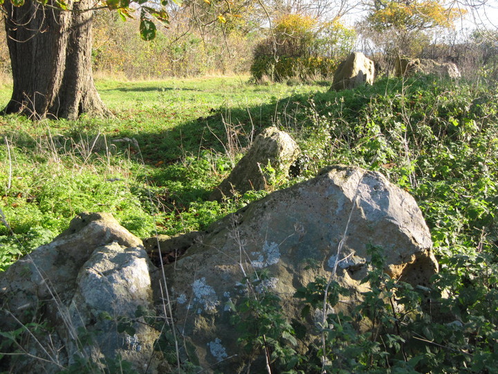
This long barrow lies near Rode church, and is apparently a popular spot for local people to scatter the ashes of their departed loved-ones*. Also it is a spot on the Mary or Michael ley (I forget which), which some people believe crosses from Cornwall to East Anglia, and is explored by the dowsing writers of 'The Sun and the Serpent'*. In the Bath Nat. Hist. and Antiq. Field Club journal for 1872, there is an account of an excursion to the area. They spoke to a local man who said that the Bed and Bolster was once twice as large as it is now, adding that when people had tried to take the stones away, bad weather had always prevented them. At the time about 22 sarsens were visible, with 5 upright - 3 or 4 (strange they couldn't remember) at the east end, and one large flat one at the west. The writer also noted that the site was in full view of the Wiltshire Downs and the White Horse (at Westbury). (on my visit in 09/07 you could certainly not see the horse, and only part of the downs if you walked further along the path). |
Posted by Rhiannon 26th April 2002ce Edited 26th September 2007ce |
Miscellaneous |
|
|
Well as people find it difficult to get to, some information from Jody Lewis's 'The Neolithic of Northern Somerset' She says that when she surveyed it in 1998 that they found over 30 stones, some standing, some recumbent, the stone following the long axis e/w. Stones remaining seem to be a section of passage at the east end, a chamber opening off and a chamber at the end, and that around the end chamber, are many stones that have the appearance of fallen capstones. It looks like she is saying that quarrying took place as well, and stones put back in are field clearance...... four chestnut trees on the mound and a lot scrub around, so unfriendly farmers, and large trees on top! There is a whole cluster of longbarrows in this area, ruined by farming mostly... Big Tree; Orchardleigh; Giants Grave; Barrow Hill; Fromefield, and slightly further afield Brays Down, and Stoney Littleton which of course is the best preserved of the whole group here. |
 Posted by moss
17th August 2009ce |
Links |
|
Natural EnglandMap showing the permissive path to the stones and how it links up with the public footpath. |
Posted by Rhiannon 23rd January 2013ce Edited 23rd January 2013ce |