Showing 1-50 of 509 posts. Most recent first | Next 50  
|
Radio 4 programme Making History.
The Tristan Stone - is it the Tristan who loved Isolde?
Listener's query:"I live in Fowey, Cornwall, and outside of Fowey there is a monolith with the legend 'Here lies Tristan son of King Mark'. Is the Tristan on the stone monolith the Tristan of the Tristan and Iseult story?": Brief summary:The Tristan Stone, near Fowey in Cornwall, is a weathered monolith about 9 feet high like a Neolithic standing stone. It might even be a Neolithic stone, but it has a worn inscription on it: Drustans hic iacet Cunomori filius, which means "Here lies Drustanus, the son of Cunomorus". Continues...
|
According to John Barnatt in his book
'Prehistoric Cornwall' 1982
IBSN 0-85500-129-1
"This site was first noted in 1921 by Crawford, from information by Breton, as a 'circle stone'.
It is likely to be either a group of natural boulders or the pound nearby."
I think the Crawford that Barnatt refers to is- Osbert Guy Stanhope Crawford 1886-1957
O.G.S. Crawford was a pioneering aerial photographer and British archaeologist.
His publication Wessex from the Air (1928) was his first collection of aerial photographs of archaeological sites
Not sure if this helps much.
Barnatt also gives a slighty differrent
grid ref of SX24757755
|

|
Cornish Hillfort For Sale
Concerns as Iron Age Fort Goes on Market - From This is Cornwall, 11:00 - 15th November 2004
An Iron Age hill fort is due to go under the hammer next month - to the delight of entrepreneurs but the concern of historians and locals. Lindsey Kennedy reports
Historians and a school have raised concerns about the sale of an historic hill fort in Penzance, which is to be put up for auction next month. Historians and a school have raised concerns about the sale of an historic hill fort in Penzance, which is to be put up for auction next month.
Lescudjack Hill Fort, the area's largest Iron Age settlement, is for sale through Fulfords Estate Agents in Penzance, with a guide price of £28,000.
The estate agent said there had been "a lot of interest" in the site.
The area of land off Pendennis Road, Penzance, extends to around one hectare or 2.5 acres - and has breathtaking views over Penzance to Mount's Bay and the Mousehole Peninsula.
In the sale particulars, the estate agents suggest the land is suitable for "general amenity, equestrian or perhaps parking on the quarry area to the south-east" subject to planning permission.
The historic site will be put up for auction on December 2 at the Novotel, Marsh Mills, Plymouth, unless previously sold,
Ian Addicoat, a local author and historian, is among those expressing concern about the pending sale.
He said: "Clearly it is imperative that such an historic and important site is maintained and preserved correctly".
"I think if there were any plans to develop such an important site there would be an outcry, and I would be very surprised if the planners would allow it".
He said the site was currently overgrown, adding: "I hope whoever takes it on appreciates its history and considers allowing it to be used as an amenity".
"I'm not sure the public is aware of its significance. They probably think it's a field with a nice view. But historians are certainly aware of what it represents".
Historian and writer Craig Weatherhill, who mentions the hill fort in his book Belerion, said it dated back to around 300BC.
"It is extremely important to Penzance and over the decades it's been treated pretty shamefully", he said.
Hill forts were fortified settlements which began to appear in upland areas, especially in southern England.
They were often massive, complicated structures with surrounding ramparts and ditches. Some of them served as small towns and administrative centres, as well as fortifications at times of conflict.
Although the Penzance hill fort is overgrown, the site has never been properly explored and could reveal many archaeological secrets.
Mr Weatherhill added: "Some 15 to 20 years ago there was a proposal to do a hefty excavation but it came to nothing. It has never really been dug properly".
"I would be delighted if local historical groups are successful, because they would have the well-being of the site at heart".
Nikki Owen, headteacher of Penzance Infants School, which is close to the ancient site, said the news of the sale was "very disappointing".
Two years ago children from the school gave some serious consideration to what they would like to see happen to the old Lescudjack Hill Fort site.
The children made the site their summer project and set about gathering names on a petition calling on the local councils to carry out some improvements.
Some 30 children from Year Two visited the then Mayor of Penzance, Ruth Simpson, and presented her with a 500-name petition calling for the site to be refurbished.
"It took us some time to track down the owner of the site, who turns out to be somebody in Newlyn," Mrs Owen said.
"It is very disappointing that it is being sold off.
"I only hope that any future owner will develop it as a public amenity and show its historic significance."
|
Archaeologists from Cornwall County Council's Historic Environment Service are uncovering the early history of Scarcewater, near St.Stephen-in-Brannel, where work on a much needed tip for the china clay industry is to begin shortly.
read more...
|
Dig Reveals Story of Prehistoric Cornish
09:30 - 14 October 2004
Thisiscornwall website
Evidence of prehistoric activity dating back to the Neolithic era has been discovered on land in Scarcewater, near St Stephen, where work on a china clay tip is to begin shortly. Archaeologists from Cornwall County Council's Historic Environment Service have been uncovering the early history of the area and will present their findings during an invitation-only open day for interested groups and local schools later this month.
The team is working closely with china clay company Imerys, which is funding the project and assisting with the removal of modern layers from the site.
During the excavations, finds and features have been uncovered which appear to represent four stages of prehistoric activity - Neolithic, early bronze age, middle bronze age and the later bronze/iron ages.
Previous fieldwork carried out by the HES revealed a long history of ceremonial and settlement activity at Scarcewater spanning five millennia.
Senior archaeologist Andy Jones said: "The excavations at Scarcewater are the largest archaeological excavations to be undertaken in the county and are providing a fantastic opportunity to investigate shifting prehistoric settlement patterns over several millennia."
Imerys community and public relations manager Ivor Bowditch said: "The company is always conscious of its responsibility to preserve or record historic data which unfolds as the industry itself develops.
"Not in all cases can preservation be made due to the nature of the extractive business, but, as in the case of Scarcewater, we were able to fund professional, archaeological work to retrieve important data and record for posterity the finds of such an excavation."
l Anyone interested can contact Andy Jones from the HES on 01872 323691 or email [email protected]
|
St Keverne local history website has this interesting page by Margaret Hunt,
Amazing pictures and details of the excavation carried out Oct 2003......
The fogou tunnel, when excavated, revealed a magnificent structure with walling up to 1.5 m high and a scatter of huge lintel stones lying haphazardly just above the floor level. A possible human tooth was found lying near the floor surface next to pieces of black burnished ware pottery.
|
Bronze Age Pot Goes on Display at Barnstaple's Museum
From BBC Devon:
A Bronze Age pot goes on display on Monday at Barnstaple's museum.
Archaeologists discovered the vessel on a farm in Parracombe last year, where it was carefully dug up and preserved.
Now the pot can be seen by the public while historical experts investigate if there is further evidence of life around the area.
|
TV shows spark 'gardening' crime
BBC Devon
Garden makeover programmes are being blamed for an increase in the theft of ancient artefacts from Dartmoor.
Electronic tags are being used to help protect valuable stone crosses and troughs in the area.
Officials from the Dartmoor National Park Authority say the popularity of TV garden series could be triggering more thefts.
New security measures follow a recent attempt to remove a granite cross.
Jane Marchand, an archaeologist with the park authority, said: "Unfortunately we have lost a number of artefacts and there has been a recent attempt to remove a cross from the moor.
"It is hard to say who is to blame, but I think it's an interest in garden ornaments from TV gardening shows.
"If you look through auction sales they very often have granite objects for sale."
The new measures will mean any stolen artefacts can be traced using an electronic scanner.
A microchip, about the size of a grain of rice, is inserted into the granite so it is invisible.
Ms Marchand said: "I think it's very sad that we have to do this.
"I can't understand how anyone could think of removing these things.
"But there is some strange irony that we are using the latest technology to help protect these very ancient artefacts."
|
"I'm a Christian and a Druid"
Cornwall's Arch Druid Ed Prynn believes it's possible to be both a Christian and a Druid. He told BBC Cornwall what his faith means to him.
Ed Prynn's site
Cornwall has the reputation of being a magical, mystical and spiritual place. We went to see Arch Druid Ed Prynn to discuss the Merlin, angels and marrying for a year and day...
"Being the Arch Druid of Cornwall is a special, unusual job. I didn't get elected it fell out of the heavens for me."
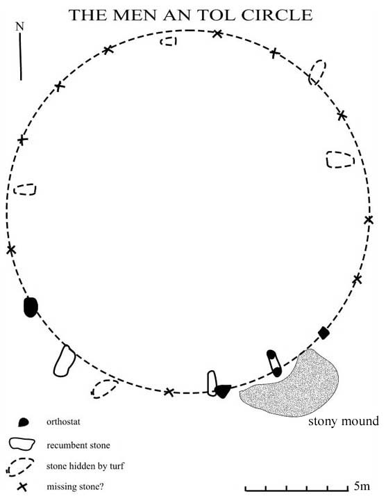
The healing stone is a replica of the Men-an-tol holed stone.
Ed refuses to have his faith bound by other people's ideas: "I was born locked into both faiths - Christian and Druid.
"Being a Druid you are a free spirit. The door is open to explore all the magic - the angels, the little people, the ley lines. Druids can experiment with all the things which are forbidden by the Bible.
"I go to chapel but everything's from the one book. People ask me how can I be in both camps but spiritual camps are not like political or military camps. It's all about loving one another. It's all about trying to be one."
Prynn had his first mystic encounter at the age of 9 and became drawn by the power of standing stones.
He started to put the stones in his garden in 1982 and the last stone was put in 1999 to celebrate the total eclipse.
"The stones here have made new spiritual history. Thousands of people have touched the stones and left some of their magic aura. Being a Christian you are supposed to follow the teaching of the Bible.
"The stones are important because the energy gets drawn into them. You can feel this type of energy, you feel a bit wobbly on your feet."
"Cornwall is a special place - we're not like a big city, we have a different way of life completely. Cornwall has all these old stones, cultures and ways. The ways have never died out and the people around who know how to make the magic work."
The showpiece of Ed's stones is the Angel's runway: "The rocking stone provides a seal so that a spell would work. It's used for swearing in of priests and priestesses, healing, fertility - people even write their lottery tickets on it.
"The Rocking Stone has magic energy lines around it. The site can be magic or people can be magic. I believe both are here and that the Godly mystique has come to this place."
Ed is happy to accept visitors to his home in St Merryn to see the stones. You can't miss it...
|
|
Ther are many breaks in the monument but if you plan to try and trace the remains, it starts at SX141572 and ends roughly at SX247536
|

THE GIANT'S HEDGE
This Dark Ages earthwork ran at least from Looe to Lerryn, south of Lostwithiel, probably marking and defending the border of a Cornish Kingdom, often supposed to be that ruled by King Mark of the Tristram and lseult (Tristan and Isolda) story.
Dr Keith Ray, the County Archaeologist for Oxfordshire, who is making a special study of the Giant's Hedge, is convinced that it originally continued on the west side of the River Fowey and was defended there by Castle Dore.
Remains of other such forts are dotted elsewhere along the Hedge, such as Hall Rings and the one above Yearle's Wood, close to the site of St Nonna's Chapel . In some places it is still twelve feet high, and where it is best preserved (for example, in Willake Wood) it is stone-faced and flanked by a ditch.
"Even 180 years ago," writes Andrew foot in his history of St Veep, "it was sixteen feet high and ten feet broad so that fencibles in Quiller Couch's book, 'The Mayor of Troy Town', could march along its entire length.
What a tremendous labour it must have been to build, 1200 years or more ago, with nothing more than basic tools. " At the Looe end it is not well preserved, but is still recognisable in places, a bank following the contours fairly near the eastern or southern edge of the wood, although it would originally have been built out in the open, probably topped by a hedge (wall) or fence.
From Bob Acton's
Around Looe, Polperro & Liskeard by Landfall Publications
IBSN 1 873443 22 6
|
|
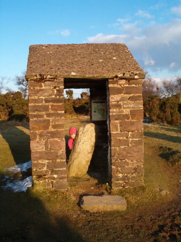
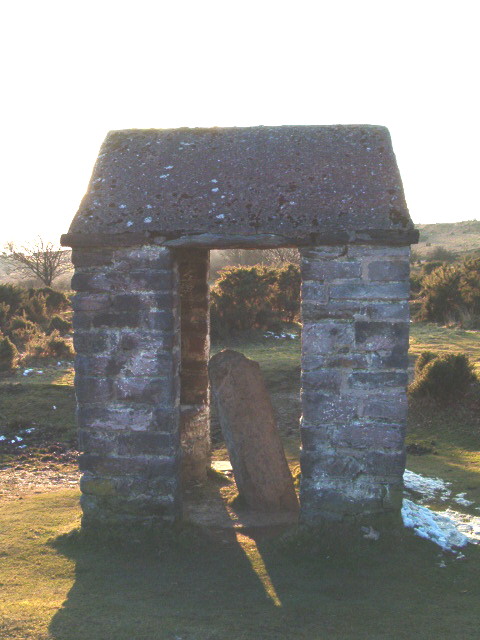
Viewed from the road this looks like a little bus shelter. We had to laugh when we got up close the dear little stone looked so cosy in his little house. The stone has a latin inscription on one side so it looks likely that this stone has been reveared since at least the 5th or 6th centuries. Other sources say it could have been a re-used standing stone from the Bronze age. It stands at the head of a stream. The sign board inside states that the little hut was erected in 1906 for protection.
|
 
|
To the west of Long Bredy is the Iron Age/Romano- British site of Pins Knoll which is a flat topped spur which juts out to the north of Litton Cheney.
An excavation of Pins Knoll found several burial sites of the 1st century ad which also contained grave goods including parts of sheep as well as the usual food vessels.
At the bottom of the spur is a spring where finds of pottery dating from the Iron Age/Roman Period
read more at....
http://www.longbredy.freeserve.co.uk/index10.htm
|
Thedorsetpage.com
Dudsbury Camp, an ancient site overlooking the Stour, from which the Ancient Britons guarded the ford across the river.
Although Dudsbury was named after a Saxon called Dude, it was first fortified by men 150 years before the birth of Christ. Today it is still a camp, but for a more friendly people. Girl Guides fill its vast sward each summer with giggling girls singing around camp fires.
|
The stone was originally found at Constitution Hill about half a mile away. The stone lies under some mature trees in what was formally the grounds of the old library. A new housing development has sprung up around it.
The address is now "Clarkes Court" just off library Road.
|
  
|
Save Gloucester Archaeology Unit
RESCUE - The British Archaeological Trust
Gloucester Archaeology Unit is threatened with closure. Gloucester City council are currently considering a number of ways to save money for next year, and the Archaeology Unit is a prime target.
Alex Hunt of the CBA reports that the proposal is apparently to cut the field unit section. According to the local Unison branch 5 out of 7 staff will go and the service will be reduced, relocated and refocused on providing purely planning advice and monitoring. The council plans to make a decision on the proposal on 16th October, so there is only a relatively short time in which to lobby them.
Not only is the unit a valuable service and an integral part of preserving Gloucester's unique heritage, but closing it would save the council very little, only £28,000 in fact which is less than half of what the unit would have made in profit had it not been stopped from tendering for work.
Anybody who has ever dealt with the unit knows what an important role its staff play in protecting the archaeological remains of Gloucester city but also the incredible amount of 'educational extras' such as the yearly field school, events and work experience placements which will be lost.
Supporter Rebecca Briscoe, says 'personally had it not been for the huge part the unit had to play in my archaeological awakening I would not be heading off to one of the top universities in the country to study archaeology at the beginning of this term. The presence of a unit so near to where I live and work was instrumental in the amount of works experience I and many budding archaeologists like me have gained. The incredible staff, whom I cannot praise enough, are too valuable a resource of experience and expertise to be discarded because of budget mismanagement by the city council.
In light of this anyone who feels strongly about this matter should write to
Kevin Stevens, Leader, or Paul Smith, Managing Director,
Gloucester City Council, The Docks, Gloucester, GL1 2EP,
or the local paper The Citizen
|
Dartmoor National Park Authority
The rampart on East Hill stands 3 metres high in places and has a wide, flat-bottomed, ditch on the outside. East Hill is properly termed a promontory fort, rather than a hill fort, having been built at the end of the East Hill ridge to take advantage of the natural defences provided on two sides by the steep wooded slopes above the East Okement River and the Moor Brook.
East Hill Iron Age fort lies on moorland south east of Okehampton and can be approached from a number of directions using public rights of way.
Hill forts are characteristic of the middle and later Iron Age (500BC - AD 50) and are seen to be the fortified settlements of the Celtic people. At least 12 hill forts survive on Dartmoor. East Hill fort is at grid reference SX 604 941.
Records show that East Hill fort was examined by the Reverend H G Fothergill in 1840. One hundred years later John Brailsford undertook a very small-scale excavation on the central entrance which divides the rampart in two. He found that the end of the rampart was neatly faced with eleven courses of small slabs and there appeared to be a palisaded trench forming a passage into the entrance. No other finds were recorded. A nearby outcrop of rock is known locally as 'Roman Chair'. This name possibly arises from the 19th century discovery of a horde of 200 Roman coins in the East Hill Area.
|
www.pastscape.org
A ring ditch at Cassington partially excavated in 1932. The site comprised two concentric circular ditches. The inner was penannular, with a narrow causeway (emphasised by an outer spur ditch) on the west. At the surface of the gravel it was 4 feet wide and up to 21 inches deep. Its outline was slightly iregular, suggesting construction in segments. It appears to have had a maximum diameter of circa 45 feet. The outer ditch was continuous and less substantial, measuring around 1 foot deep and a maximum of 3 feet wide. It was more irregular in appearance than the inner ditch. The excavator suggested that, on the basis of the asymmetric ditch fill, the inner ditch had originally been accompanied by an outer bank. The inner ditch offered insufficient evidence for the location of a bank, if there was one. Most of the topsoil had been removed prior to excavation, although in what remained were some Roman potsherds and some tile of Medieval or later date. Further probable Roman sherds were in the uppermost levels of the inner ditch. In "the deepest level" was a sherd which was described in the excavation report as being "not impossibly Bronze Age in date". A subsequent publication (Hamlin and Case 1963) refers however to "Struck flints and sherd possibly of Peterborough ware in primary silt. Peterborough ware and Roman-British pottery in secondary silt". While the possible presence of Peterborough Ware hints at a possible Neolithic date for the inner ditch at least, the sherds may of course represent debris from earlier activity. The published report offers insufficient information on the potsherds' context and condition.
|

|

|
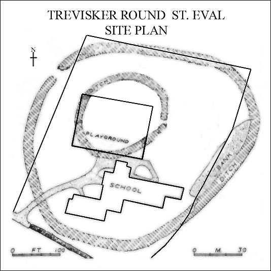
The following notes written some years ago come from pamphlet on the history of St. Eval Airfield by Mr Alan Bell.
"In 1955 and 1956 a Mr E. Greenfield carried out excavations on behalf of the Ministry of Works on the site currently occupied by Trevisker School and playground.
An excellent report headed "The Excavation of Bronze Age and Iron Age Settlements at Trevisker, St. Eval, Cornwall" was published by the Prehistoric Society in 1971.
This summary indicated that the site was first occupied in the Bronze Age by a small agricultural settlement, consisting of two circular timber houses; one house was eventually replaced by a stone structure. A single radio carbon determination suggests that the settlement was dated within the period 1700-1300 BC.
With the number of scattered barrows in the district it has been postulated that in the Bronze Age there would have been a population of 200-250 in 30 to 50 scattered homesteads, like Trevisker, on some 2,500 to 3,200 acres of cultivable land.
IRON AGE
The Iron Age settlement was established on the Trevisker site probably in the second century BC or earlier. An original inner enclosure, half an acre in area, housing a single defended farmstead, was later super-seded by a larger defended enclosure. This covered three acres and contained circular timber houses and occupation areas. This phase was followed at the end of the first century AD by a Romano-British period of occupation, which lasted until the middle of the second century.
Trevisker bound lay in an area densely occupied in the Iron Age - there were at least 16 known or presumed Iron Age sites within a seven miles radius. These included the cliff castles of Redcliff Castle and Park Head in the St Eval parish and the great contour hill fort of Castle-an-Dinas. Seventeen iron specimens excavated from Trevisker were analysed and these varied widely from high silica slags to samples with 50% to 60% iron. This provides proof that iron, albeit impure but typical of the period, was smelted nearby even though a furnace has not been discovered. However, it is likely that the iron ore was of local origin as Carnewas Point mine was worked in the late 19th century.
By this period the settlers were living in stone huts with slab lined drains, and it is likely that the cattle were enclosed at night or in inclement weather. Spindle whorls were found indicating that sheep were kept and their wool used for clothing. The existence of rotary grinding wheels and clay ovens suggest that cereals were cultivated."
|

|
Torc Discovery Rivals Snettisham Hoard
Eastern Daily Press
Torc discovery rivals Snettisham hoard
An Iron Age torc unearthed in a Norfolk field this summer has been hailed as an exceptional find on a par with the famed Snettisham hoard.
Norfolk Museums Service expert Dr John Davies said the item dated back to the Iceni tribe, probably a generation before Iceni leader Boudicca lived.
He said: "It is indeed a very fine example. It compares with some of the very finest examples that have turned up at Snettisham.
"It's a very exceptional find, a delightful find in many respects because it's aesthetically beautiful.
"The number we have of these isn't vast, so every one that turns up is important."
Dr Davies said he would love to see the artefact, which was found by farmer Owen Carter in July and declared treasure by a coroner last week, on display in the Castle Museum, Norwich.
"It would be lovely for people to come and see and appreciate the magnificent craftsmanship of the people of the time," he said.
"We would be interested in acquiring it if we possibly can. It's something we would love to put into our Boudicca gallery."
But the museums service will have to wait for the torc to be valued and then look into applying for funding.
A report by Dr JD Hill of the British Museum revealed that the item, which was made between 200 and 50 BC , survived more than 2000 years intact before suffering recent minor damage from agricultural machinery.
He added that it was similar to the "Snettisham Great Torc, but lacking the elaborate La Tene or Early Celtic design".
Dr Davies said the electrum torc would have belonged to a prestigious figure in Iron Age Norfolk and Boudicca would have worn similar jewellery.
"It would a badge denoting how prestigious they were, belonging to a tribal chief for example," he said.
"We can tell they were someone very important in the society because of the value, craft and care that was spent on them.
"It adds to our understanding of the great wealth possessed in west Norfolk at that time, which suggests it was a very important area."
|
The museum officially opened to the public in 1980.
The Museum and Hut Circle are open to the public free of charge by kind permission of Mrs Hadley, throughout the year by appointment (contact 01326 280130/434) and every Wednesday in August, 10am-5pm.
|
Poldowrian Site and Archaeological Museum
Poldowrian is a multi-aged site ranging from the late Mesolithic to the Iron Age (c5,500-200BC), situated between Coverack and Kennack Sands, (NGR SW 74851690).
It was discovered in 1967 by the late Mr Peter Hadley and Mrs Hadley who had moved to the farm in 1964. Mr Hadley had always felt that the area had possibilities for archaeological discoveries with its close proximity to the Lankidden Iron Age Cliff Castle and a cliff fire in 1967 was to be the beginning of remarkable discoveries.
|
Trevelgue Headland is a public open space owned and maintained by Restormel Borough Council. It is one of the most heavily defended headlands in Cornwall, but as a result of natural erosion and visitor pressure, it is probably also one of the most heavily eroded. Natural erosion at the narrow middle point of the promontory, where the majority of the defences are concentrated, has left part of the headland as an island, known as Porth Island.
The entire headland is protected as a Scheduled Ancient Monument and lies in designated Areas of Great Historic and Scientific Value. It contains an impressive promontory cliff-castle, dating to the Iron Age, and two Bronze Age barrows.
As a result of natural erosion and visitor pressure, the archaeological sites on Trevelgue Head have been heavily eroded. In 1999, English Heritage produced a management plan, which identified the various problems and suggested a programme of remedial works.
The cliff-castle or promontory fort is defined by a spectacular series of large earth and stone ramparts which cut off the headland and embrace the remains of an extensive Late Iron Age settlement and lies adjacent to a contemporary field system. It defended an east-west headland 700m long and protects, on its south side, the excellent natural harbour of St Columb Porth.
The Barrow
The heavily damaged Bronze Age barrow dates back to around 2,000BC.
Bronze Age barrows are burial mounds, often with a stone core covered over with earth. The barrows may contain cists (stone-lined box) which contain cremated bone or burials. Such sites traditionally date between 2000BC-1600BC.
The earliest documented archaeological explorations of Trevelgue Head took place at the beginning of the nineteenth century when the barrows on the headland were opened up by Canon Rogers in 1840. This was apparently followed by further antiquarian ventures reported in the local press in the 1870s. A more thorough examination of two barrows was undertaken by William Copeland Borlase also around this time and in 1872, a detailed account of his discoveries was presented in the book Naenia Cornubiae.
Other archaeological work
Interest in the significance of later prehistoric activity on the headland was ignited by the discovery of what was described in the 1890s as a small "prehistoric bronze foundry".
During a visit by H.O'Neill Hencken to the cliff castle in the early 1930s a surface scatter of "numerous pieces of Iron Age pottery...and quantities of flint chips" were collected. Erosion of midden deposits, containing metallic ores and slags, which appeared, in part, to form the make-up of the extensive defensive ramparts, threatened the stability of these impressive earthworks. Provisional arrangements for an archaeological excavation were made in 1934 but did not happen.
Finally, he Cornwall Excavations Committee (on behalf of the Royal Institution of Cornwall) invited C. K. Croft Andrew to carry out some limited archaeological excavations on the island during the summer of 1939. Evidence for occupation dating from the 3rd century BC to the post-Roman period (c.5th or 6th centuries AD) was uncovered. The outbreak of war in September 1939 halted work on the site.
Andrew's excavation took place entirely on the Island. Four trenches were excavated into the western two ramparts and two further trenches to the west where a round house was excavated.
Welcome to Restormel
|
Airlift Restores Ancient Headland
Dramatic Scenes On North Cornish Coast
50 tonnes of headland soil moved
Trevelgue Head (Porth Island) was closed to public access earlier this week to enable an airlift of material to repair an ancient Bronze Age barrow on the island near Newquay.
Despite strong winds and heavy rain, on Wednesday 29th October, staff from Restormel Borough Council, in partnership with the County Council's Historic Environment Service, co-ordinated an airlift of 50 tones of headland soil by 771 Naval Air Squadron Culdrose.
The repair became necessary to overcome the effect of natural erosion as well as the wear and tear of the many visitors who come to enjoy the spectacular coastal views. Transporting the quantity of material across the narrow footbridge by hand would have been impossible without the help of the Navy.
Cllr Michael Burley, portfolio holder for Tourism & Leisure at the Borough Council commented: "This barrow is one of a number along the North Coast near Newquay showing the importance of this whole area in the Bronze Age. We are extremely grateful that 771 Naval Air Squadron were able to assist us in repairing this prestigious site."
Twenty-two staff from Restormel's Parks Service, together with support from the BTCV (British Trust for Conservation Volunteers) braved the atrocious weather to help with the unloading and distribution of the soil. Despite the conditions everyone pulled together in a good team effort, pleased to be involved in an important and exciting project.
Now that the soil has been deposited on the headland, a small team from Restormel will be carrying out conservation works on the Barrow and nearby footpaths in early November.
This project is the latest in an ongoing programme of work to preserve the archaeology and fabric of the Headland. A management plan drawn up in 1999 by English Nature identified a number of issues, including the need to repair to ramparts of Iron Age cliff castle, which made Trevelgue one of the most heavily defended headlands in Cornwall. In 2001 and 2002 damage to the cliff castle's ramparts was repaired while the new footpath and steps were laid through the ramparts.
Further work on the island is planned, but staff are hoping for better weather next time! For further information or pictures, please contact Dick Cole, Archaeologist for Cornwall County Council or Andrew Pidgen Parks & Amenities Manager Restormel Borough Council.
Welcome to Restormel
|
Fogou Excavation On Lizard
October 22, 2003: http://www.cornwall24.co.uk/news/
Archaeologists from Cornwall County Council's Environment and Heritage Service have begun a three-week excavation to investigate an ancient fogou at Higher Boden, near Manaccan on the Lizard, which was recently discovered by a local farmer.
Fogous were last in the headlines in 1996 when Channel Four's Time Team devoted a programme to these puzzling Cornish monuments.
Named after the Cornish word meaning 'cave', fogous are remarkable prehistoric monuments consisting of a stone-lined passage roofed with massive capstones. Many also have side tunnels dug into the natural subsoil and a few have evidence of circular underground chambers.
They are found only in the extreme west of Cornwall, mainly on the Land's End and Lizard peninsulas, and were always built within and beneath settlement sites. Evidence shows that they were built more than 2,000 years ago ago during the later Iron Age (400BC to AD43) and have similarities with underground monuments known as 'souterrains', which are broadly contemporary but are found in other parts of Britain and Ireland.
Charlie Johns, county council senior archaeologist and project manager, said: "Nobody knows exactly what fogous were built for. The three most popular theories are that they were refuges in times of trouble, cellars for storing food and livestock or that they served a religious or ritual function - perhaps it was a combination of all three. This is an amazing and extremely rare discovery."
There are only eleven other definite or probable fogous in Cornwall, only two of which have been excavated in recent years - Carn Euny, near Sancreed, in 1978, and Halliggye, near Trelowarren, in the early 1980s - although these revealed little evidence as to the function of fogous.
This latest excavation is sponsored by English Heritage, which has provided specialist support for the project.
Site visits and tours will be conducted by county council and Royal Cornwall Museum staff. Students from Truro College, local volunteers and the Cornwall Archaeological Society have been assisting with the work.
All about fogous
A fogou, or underground tunnel, has been documented at Boden since the early 19th century, when it was viewed and recorded by Polwhele, the vicar of Manaccan and St Anthony. The reports of later writers (Cornish 1906, Henderson 1912 and 1916) appear to "embellish Polwhele's original report without reference to any further field observations" (Linford 1998, 188).
The site lies on a southerly slope near the summit of a gentle hill, some 300 metres to the west of the Boden Vean settlement (SW 7685 2405) itself one kilometre south of Manaccan village on the Lizard peninsula. The below-ground remains have been part uncovered following two separate incidents in 1991 and 1996, while discussions with local residents have shown that the fogou had previously been exposed 75-80 years ago.
There are only 11 other known definite or probable fogous: Boleigh, Carn Euny, Castallack, Chysauster, Halligye, Higher Bodinar, Lower Boscaswell, Pendeen, Porthmeor, Treveneague, Trewardreva, and 20 or so possible ones. Of these, only two have been excavated in recent years - Carn Euny (Christie 1978) and Halligye in 1982
In the interim note on Halligye, Bill Startin pointed out that "despite revealing quite a lot of information about the Halligye site, these limited excavations have revealed little further evidence as to the function of fogous".
|
Walk Around Cerne Abbas 8th November 2003
This walk may be more interesting to geologists but looks interesting....
The walk starts at the spring which rises from below the Upper Greensand. A huge quarry on the eastern side of Giant Hill, in the Lower and Middle Chalk, provided building stone for Cerne and probably other villages. The walk goes over the top of the hill, which is covered in a thick deposit of Clay with Flints. The valleys at Minterne Parva and Upcerne are also on the Greensand.
The main building stones in Cerne Abbas are the Lower and Middle Chalk and Lower Purbeck limestone from the Ridgeway quarries. The Lower Chalk may be identified by its gritty texture, with the occasional dark grain of glauconite. The Middle Chalk has been used in huge blocks in the medieval North Barn (now Beauvoir Court). The Lower Purbeck, a white laminated limestone, has been used in several buildings in the main street, and for the Hospice.
MORE INFO
Cost £1.50 per person
|
The following info on Trevisker pottery I found in the Proceedings of the West Cornwall Field Club.
(Don't bother looking up info on Trevisker pottery on the net, there is none)
The pottery from Trevisker round, St. Eval is from a site which it was possible to distinguish several stages of occupation.
This was the first Bronze Age site of this kind in the U.K. and it has given us very valuable information about the developement of Cornish Bronze Age pottery.
It has proved possible to distinguish four main classes or styles of pottery which were in use successively by occupants of the site. these syles have been numbered I to IV in order of age.
Style I
Generally thick, heavy and coursely gritted, but well fired. The pots were probably two feet tall, with out-turned internally bevelled rims and large ribboned handles or similar lugs of simpler form. Some pots had their bases stengthened on the inside with crossed raised ribs
Style Ia
Similar to style I, except that the pots have flat-topped clubbed rims, and there may be horizontal ribs on the side of the pot
Style II
This style is dark in colour, and less hard fired than style I. The pots are rather barrel shaped with rims either slightly bevelled or else flattened. The decoration is by fine plaited cord arranged in a zone on the outside of the pot imediately below the rim. Paired dimples placed the zone of decoration to represent ribbon handles are a feature of this class.
Style III
This style is generally reddish brown in colour. Cord decoration is replaced by incised decoration made by scoring the surface of the pot prior to firing, but patterns remain the same. Both small perforated lugs and finer dimple handles are found on these pots.
Style IV
This style is generally brown or dark grey, harder, grittier and better fired than the preceeding styles. These pots are barrel or flower pot shaped and the rims may be flat topped, everted, of have bevel on the inner side. The decoration includes incised, finger-nail and finger-tip techniques. The patterns are probably derived from those of I-III. Cruciform base-strenghtened ribs and perorated lugs also occur in this group. There is a considerable range of fabric and size within this style and both large , course storage jars and smaller, finer cooking pots are represented.
|
|
This little known stone is built in a hedge. It is possible that in the past that it has been moved. You can look through the hole and see the Merry Maidens stone circle.
|
Reports on this site can be found in the following....
Cornish archaeology 17/1978/141
Proceedings of the West Cornwall Field Club 2/1957-8/2:41-3
Proceedings of the Prehistoric Society 38/1972/302-381
|
 
|
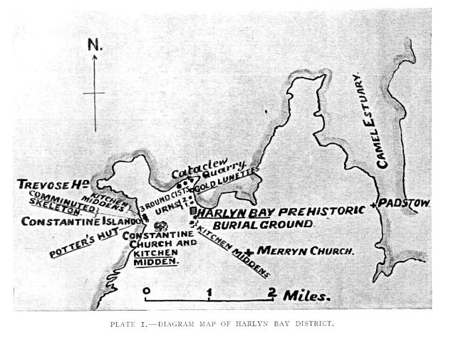
Some notes from a book called "Harlyn Bay and the discoveries of its Prehistoric remains" by R. Ashington Bullen 1912
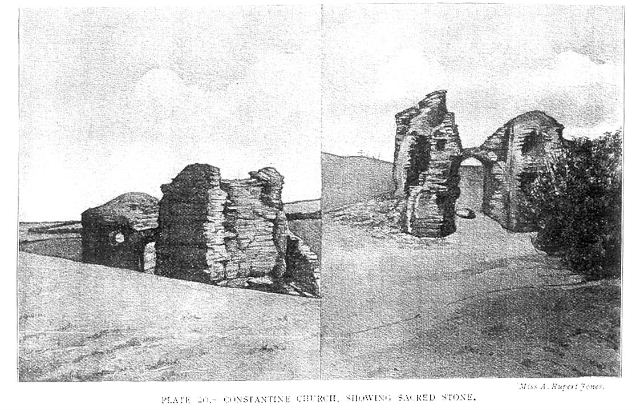
The ruins of Constantine church stand near a kitchen midden. It was built in a hollow in the sand . Underneath the ruined tower is a large boulder of Cataclew stone (plate 20) weighing apparently nearly a quater of a ton. The nearest locality for this rock is Cataclew (fig 14) about a mile and a half distant in a straight line.
This stone seems to have been a sacred object around which the tower was built, perhaps 1600 hundred years or more ago. We have a similar instance at Maplescombe Church near Faringham, Kent in which is a large mass of tertiary conglomerate at the N.E. corner. And Prof T. Rupert Jones F.R.S., considers the so-called Chair of Bede at Jarrow Church to have been a sacred stone of an early date, but known to have been chiselled by modern masons into its present rectangular shape.
If the whole surrounding mound at Constantine Church is a continous kitchen midden, as it seems likely, consisting of successive accumulations, the great boulder marked the meeting point for whatever religious or ceremonial rites were practised. the Christian Missionaries who built Constantine Church made the spot the centre for the new religion, including the stone within their edifice in a position of honour.
|
Crack in the Golden Cap
Report from www.thisisdevon.co.uk website
09:00 - 10 July 2003
Beachgoers have been advised to think before they sunbathe or walk under cliffs, following the appearance of a crack in the Golden Cap, near Charmouth in Dorset. Chris Pamplin, earth sciences adviser for the world heritage team which looks after the Jurassic Coastline, said: "There is indeed a pinnacle of rock teetering on the brink of falling. It will fall, but the timing is anybody's guess. It is of little danger to the general public using either Seatown or Charmouth beaches and would only pose a threat to walkers going around the base of the cliff at low tide.
"However this is a very obvious lump of rock. All beach users, wherever they are, be it Dorset, Devon, Cornwall or any other part of our coast should be aware that rocks can fall with no notice from any of our cliffs."
http://www.thisisdevon.co.uk/displayNode.jsp?nodeId=77707&command=displayContent&sourceNode=77259&contentPK=6315580
|
Gun Rith retains its lean
Cornish newspaper "The West Briton" expands on the recent news about Gun Rith Menhir
The restoration process has been carefully planned to ensure that the area is safe for visitors and to make it look exactly as it did before the accident - even down to replacing it with a lean.
Ann Preston-Jones, senior archaeologist at the historic environment service said: "We wanted to make sure that although the stone was going to be built back into the hedge, it would remain as visible as it had been before.
"However, as the stone had almost no foundation and a 15 degree lean, it had become very unstable.
"The only way to make it safe without a base would have been to place it completely upright and to bury it so deep that it would have appeared very much shorter and become rapidly overgrown by trees and shrubs.
"We therefore came to the conclusion that it would be best to stand the stone up in a base as it is something that we have done before for medieval crosses.
"We felt that, in this case, it could be justified because, with the support of a base, most of the height of the menhir can be above the ground and it will be safe for it to lean slightly."
read the full story
http://www.thisiscornwall.co.uk/displayNode.jsp?nodeId=79373&command=displayContent&sourceNode=78925&contentPK=6209041
|
Showing 1-50 of 509 posts. Most recent first | Next 50
Born in Cornwall 1966.
Main interests include Hillforts and barrows. I try to cover mainly Cornish sites but about five times a year get to visit Dorset where my wifes family live. Fairly keen on folklore and earth mysteries etc.
|
|