|
|

|
|
Montgomeryshire
|
|
|
|
Sites in this group:
|
16 posts
Afon Disgynfa Cairn(s) |
14 posts
Afon y Dolau Gwynion Chambered Cairn |
6 posts
Banc Crugyn Barrow / Cairn Cemetery |
|
15 posts
Beacon Ring Hillfort |
16 posts
Bedd Crynddyn Cairn(s) |
3 posts
Beili Hwlyn Barrows Round Barrow(s) |
|
4 posts
Black Bank Hillfort |
6 posts
Blaen Clawdd Du, Cwmdeuddwr Round Cairn |
3 posts
Blaen y Cwm Ring Cairn |
|
11 posts
Breiddin Hill Camp Hillfort |
1 post
Brynar and Riddle Round Barrow(s) |
3 posts
Bryn Mawr Enclosure |
|
12 posts
Bryn y Fedwen Round Barrow(s) |
1 post
Caer Din Enclosure |
1 post
Cae y Garreg Lwyd Natural Rock Feature |
|
1 post
Carneddau'r Gwragedd Cairn(s) |
12 posts
Carneddau Hafod Wnog Cairn(s) |
1 post
Carneddgerrig Round Cairn |
|
Carnedd Das Eithin
Cairn(s)
|
1 post
Carnedd Fach Cairn(s) |
8 posts
Carnedd Gerrig Cairn(s) |
|
Carn Bwlch y Cloddiau
Cairn(s)
|
1 post
Carreg-y-tair Eglwys Standing Stone / Menhir |
15 posts
Carreg Hir Standing Stone / Menhir |
|
3 posts
Carreg Lwyd Standing Stone / Menhir |
3 posts
Cefn-Cyfronydd Enclosure |
1 post
Cefn-yr-allt Hillfort |
|
16 posts
Cefn Carnedd Hillfort |
21 posts
Cefyn y Castell Hillfort |
2 posts
Cerrig-yr-Helfa Stone Row / Alignment |
|
1 post
Cerrig Beddau Kerbed Cairn |
22 posts
Cerrig Caerau Stone Circle |
13 posts
Cerrig Cyfamod Glyndwr Stone Row / Alignment |
|
15 posts
Cistfaen Cairn(s) |
1 post
Collfryn Enclosure |
47 posts
Corndon Hill Barrow / Cairn Cemetery |
|
40 posts
2 sites Craig Rhiwarth Hillfort |
20 posts
Craig ty-glas Cairn(s) |
18 posts
Craig y Lluest, Cwmdeuddwr Barrow / Cairn Cemetery |
|
6 posts
Crosswood Enclosure |
2 posts
Crowther's Camp Enclosure |
1 post
Crugyn Round Barrow(s) |
|
10 posts
Crugyn-Llwyd Round Cairn |
21 posts
Cwmbiga Long Cairn |
10 posts
Cwm-y-Saeson Standing Stone / Menhir |
|
4 posts
Cwm Mawr Stone Axe Factory Ancient Mine / Quarry |
Cwm Rhiwiau
Stone Circle
|
11 posts
Dinas (Trefeglwys) Cliff Fort |
|
1 post
Domen Giw Cairn(s) |
3 posts
Dyffryn Lane Henge |
12 posts
Ffridd Faldwyn Hillfort |
|
1 post
Foel Cairn Cairn(s) |
12 posts
Foel Fadian Round Barrow(s) |
16 posts
Fowler's Arm Chair Cairn Round Cairn |
|
17 posts
Fowler's Arm Chair Stone Circle Stone Circle |
9 posts
Fron y Gog Hillfort |
20 posts
Gaer Fawr (Welshpool) Hillfort |
|
5 posts
Garnedd Wen Cairn(s) |
1 post
Garreg Lwyd (Fronwen) Natural Rock Feature |
19 posts
Glan Hafon cairn Cairn(s) |
|
10 posts
Glog Round Barrow(s) |
3 posts
Glonc Kerbed Cairn |
1 post
Golfa Enclosure |
|
6 posts
Graig Gethin Cairn(s) |
10 posts
Henriw Standing Stone Standing Stone / Menhir |
13 posts
Kerry Hill Stone Circle |
|
13 posts
Llanymynech Hill Ancient Mine / Quarry |
21 posts
Lled Croen yr Ych Stone Circle |
18 posts
Lluest Uchaf Stone Row / Alignment |
|
11 posts
Llwyn Bryn Dinas Hillfort |
2 posts
Llymystyn Camp Hillfort |
3 posts
Llyn Fawnog Ddu Standing Stone / Menhir |
|
3 posts
Llyn Mawr Ring Cairn |
9 posts
Llyn Mawr Standing Stone / Menhir |
7 posts
Llyn Y Tarw Stone Circle |
|
9 posts
Llys-y-Cawr, Allt Dolanog Hillfort |
1 post
Long Hill Hillfort |
7 posts
Maen Beuno Standing Stone / Menhir |
|
6 posts
Maen Hir Standing Stone / Menhir |
18 posts
Maen Hir, Glan Fedwen Kerbed Cairn |
5 posts
Maen Llwyd (Commins Coch) Standing Stone / Menhir |
|
16 posts
Maen Llwyd (Machynlleth) Standing Stone / Menhir |
5 posts
Maen Llwyd (Rhos Dyrnog) Standing Stone / Menhir |
15 posts
Maes Mochnant Standing Stones |
|
2 posts
Moelfre Round Barrow(s) |
1 post
Moel Pentyrch Enclosure |
8 posts
Moel y Gadfa Round Cairn |
|
1 post
The Mount / Bedd Garmon Round Barrow(s) |
Mynydd-y-Bryn
Round Cairn
|
4 posts
New Pieces Enclosure, Breiddin Hill Hillfort |
|
2 posts
Pant Brwynog Cairn(s) |
1 post
Pegwyn Mawr I Round Cairn |
1 post
Pegwyn Mawr II Ring Cairn |
|
1 post
Pentre Camp (Llangyniew) Hillfort |
1 post
Penycerrig Cairn(s) |
1 post
Pen-y-Clun Hillfort |
|
3 posts
Pen-y-Foel Hillfort |
23 posts
Pen-y-Gaer, Llanidloes Hillfort |
1 post
Pen Cad Cymry Cairn(s) |
|
4 posts
Rhos y Beddau Stone Row / Alignment |
12 posts
Rhos y Beddau Stone Circle |
3 posts
Roundton Hillfort |
|
2 posts
Sarn-y-Bryn-Caled Cursus |
3 posts
Sarn-y-Bryn-Caled (Destroyed) Timber Circle |
2 posts
Shentons Tump Round Barrow(s) |
|
Siglem Las
Cairn(s)
|
1 post
Soldier's Mount Hillfort |
33 posts
Staylittle Barrow / Cairn Cemetery |
|
4 posts
St Mary's Well Sacred Well |
4 posts
Tan-y-Coed Round Barrow(s) |
5 sites
Trannon |
|
3 posts
Twmpath y Crynwyr Round Cairn |
8 posts
Two Tumps Round Barrow(s) |
Waen Hir, Llandinam
Cairn(s)
|
|
5 posts
Whetstones Stone Circle (Destroyed) |
4 posts
Whetstones Cairn Cairn(s) |
8 posts
Yr Allor Kerbed Cairn |
|
11 posts
Ystradfawr Standing Stone / Menhir |
2 posts
Ystradfawr Cairn(s) |
12 posts
Y Capel Stone Circle |
|
1 post
Y Gaer (Meifod) Enclosure |
Sites of disputed antiquity:
|
1 post
Bwlch y Gistfaen Burial Chamber |
1 post
Church Farm, Trefeglwys Standing Stones |
1 post
Craig yr Arian Burial Chamber |
|
4 posts
Domen Round Barrow(s) |
4 posts
Llanrhaeadr-ym-Mochnant Standing Stone / Menhir |
7 posts
Maen Llog Standing Stone / Menhir |
Latest posts for Montgomeryshire |
Showing 1-10 of 954 posts. Most recent first | Next 10 
Moel y Gadfa (Round Cairn) — Images (click to view fullsize) |
|
 Posted by GLADMAN
31st December 2023ce |
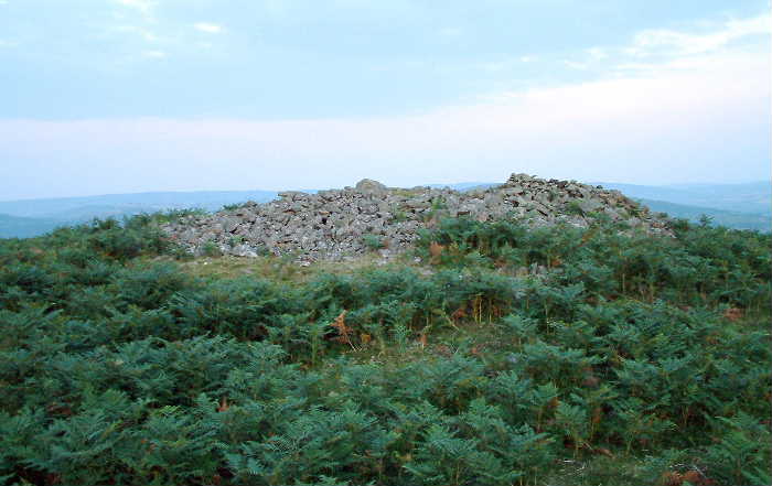
Moel y Gadfa (Round Cairn) — Miscellaneous |
|
Despite being featured upon current OS mapping I'm pretty confident that a visit to the obscure Bronze Age cairn located upon the south-eastern spur of Moel y Gadfa - the high moor ( at 1,669ft) overlooking the minor road linking the mountain pass Bwlch-y-Groes and Llyn Efyrnwy - will not grace many antiquarian-themed itineraries. Ha! Upon second thoughts, very confident... To be fair, the terrain to be found here - to the east of the magnificent Arans - is probably an acquired taste and, as such, likely to appeal only to those with a penchant for avoiding the crowds and immersing themselves in the landscape - hopefully not TOO literally, one would hope. It is pretty hard going underfoot... but hey, nothing good comes without a little effort, right? In the event I struggled to find the monument owing to fence lines on the ground not mirroring what was shown upon my map, this disorientating me more than a little as hill fog swept in to further confuse matters with reduced visibility... and driving rain. However, find it I did. Eventually. Coflein notes: "A much disturbed & spread round cairn, in the region of 7.5m in diameter & 1.0m high." [RCAHMW AP94-CS 0027 J.Wiles 26.07.04] |
Posted by GLADMAN 30th December 2023ce |
Moel y Gadfa (Round Cairn) — Links |
Moel y GadfaA very obscure Bronze Age cairn between Bwlch-y-Groes and Llyn Efyrnwy, east of the mighty Arans. |
Posted by GLADMAN 29th December 2023ce |
Moelfre (Round Barrow(s)) — Links |
Moelfre, northern Pumlumon foothillsA reminder to always check out the summit of even the lower Welsh hills... you never know, |
Posted by GLADMAN 9th October 2023ce |
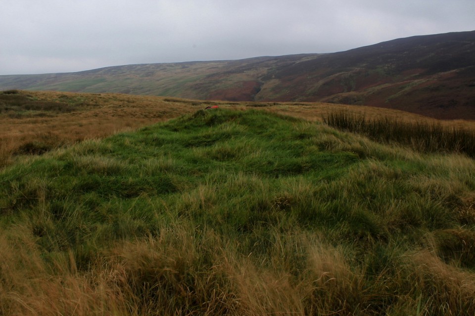
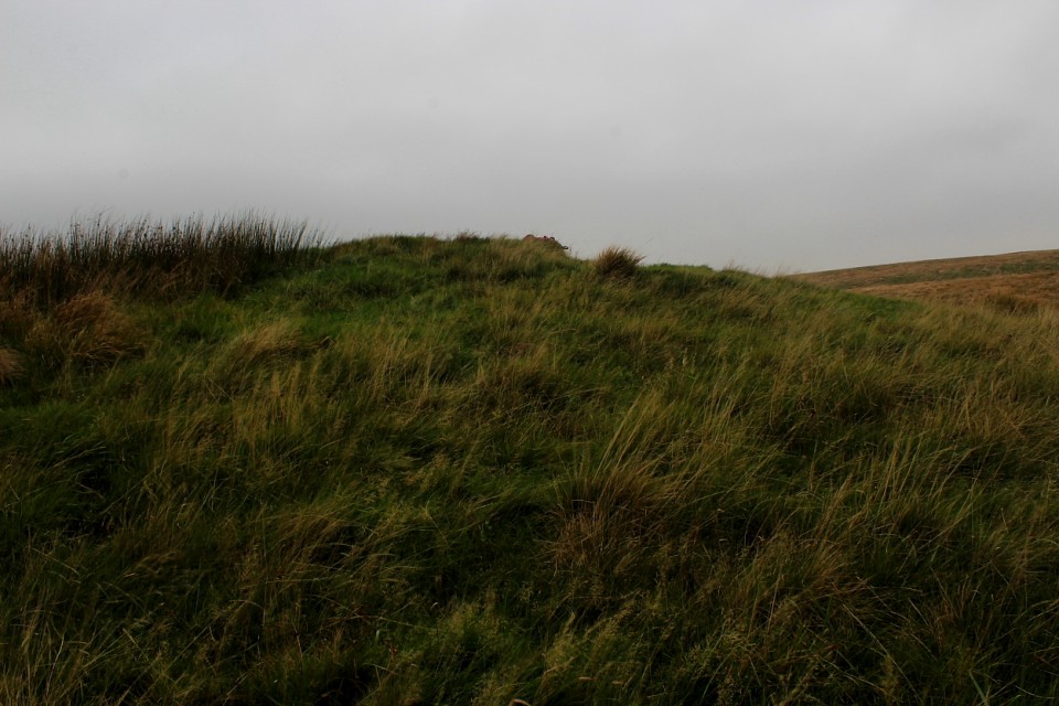
Moelfre (Round Barrow(s)) — Miscellaneous |
|
There are a number of 'Moelfre's across the length and breadth of Wales... hardly surprising, since I understand the name basically means 'hill'. This one, however, has been on my 'list' for some time since it is one of the few featuring that iconic 'Antiquarian typeface' on the OS map. To be fair, however, I arrive at Bwlch Glynmyndd to the north-east more in anticipation of the expected views than archaeological splendour. Needless to say, things are not as straightforward as they may appear from a simple perusal of the map..... OK, the views ARE magnificent, the deeply riven hills north of Pumlumon forming a twisted, convoluted landscape of sublime aesthetics. However, the expected site of the monument, indicated below and to the southwest of the summit, reveals a 'possible' circular feature, probably natural? Certainly nothing to write home about. Fortunately, the views most certainly are.. Eventually, I return to the 1,539ft summit and everything suddenly becomes clear. For here is located what very much looks like a substantial Bronze Age round barrow, more-or-less inviolate. As it happens, the professional archaeologists agree, Coflein noting: "A barrow, 17.5m in diameter, from 0.7m to 2.7m high, apparently undisturbed. There is no notice of any ditch. [J.Wiles 16.04.02]" So what of the OS feature? Is this a mistake - plain and simple - or is there indeed something there? |
Posted by GLADMAN 8th October 2023ce |
Showing 1-10 of 954 posts. Most recent first | Next 10