The Modern Antiquarian
Log in
|
Register
Home
Latest Posts
Forums
Maps
Help
Browse Sites
News
Blog
Contributors
The Books
Select
-
Belgium
Denmark
Eire
France
Germany
Greece
Italy
The Netherlands
Norway
Portugal
Republic of Malta
Spain
Sweden
Switzerland
United Kingdom
Wales
Powys
Montgomeryshire
Pant Brwynog
Cairn(s)
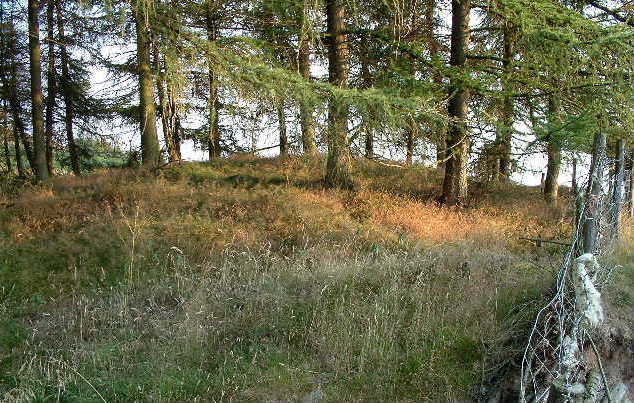
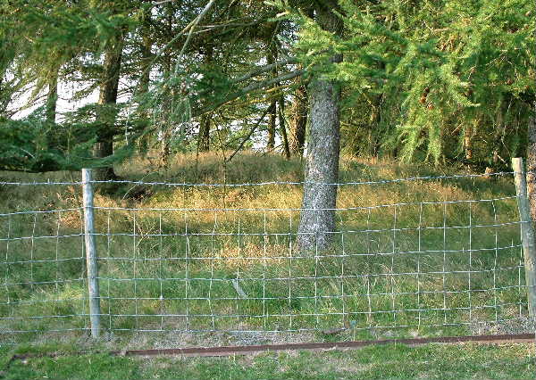
Pant Brwynog (Corndon Hill VII) (Cairn(s)) on The Modern Antiquarian, the UK & Ireland's most popular megalithic community website. 2 images, plus information on many more ancient sites nearby and across the UK & Ireland.
Image © baza
Also known as:
Corndon Hill VII
Nearest Town:
Montgomery (8km W)
OS Ref (GB):
SO300967 /
Sheet: 137
Latitude:
52° 33' 47.49" N
Longitude:
3° 1' 58.01" W
Added by
baza
Images (2)
0 discussions
Start a topic
Show |
Hide
Web searches for Pant Brwynog
Flickr
Google
Google Images
The Megalithic Portal
Bing
Stone Pages
Streetmap.co.uk
Wikipedia
Show map
(inline Google Map)
- Sites within 20 km -
-
Corndon Hill (0.5km ENE) (47 posts)
Whetstones Cairn (0.89km NNE) (4 posts)
Whetstones (0.95km NNE) (5 posts)
Mitchell's Fold cairn (1.64km NNE) (5 posts)
Mitchell's Fold (1.74km N) (117 posts)
Cwm Mawr Stone Axe Factory (1.77km SE) (4 posts)
Roundton (1.84km SSW) (3 posts)
The Cow Stone (2.37km NNE) (9 posts)
Stapeley Hill (2.59km NNE) (17 posts)
The Hoarstones (3.99km NE) (58 posts)
Castle Ring (Rorrington) (4.14km NNE) (2 posts)
Heath Mynd (4.41km ESE) (8 posts)
Roveries Hill (4.88km ESE) (2 posts)
Pennerley Barrows (5.53km ENE) (10 posts)
The Rossett (6.02km WSW) (5 posts)
The Stiperstones (6.91km ENE) (28 posts)
Caer Din (7.43km SSW) (1 post)
Ffridd Faldwyn (8.3km W) (12 posts)
Castle Ring (Shelve) (8.5km ENE) (11 posts)
Lea Stone (9.01km ESE) (1 post)
Beechfield (9.05km NNW) (2 posts)
Beacon Ring (9.74km NW) (15 posts)
Castle Ring (Ratlinghope) (10.41km ENE) (10 posts)
Dyffryn Lane (10.66km W) (3 posts)
Maen Beuno (10.7km W) (7 posts)
Billings Ring (11.16km ESE) (1 post)
Cothercott Hill (11.21km ENE) (5 posts)
Castle Ring tumulus (11.26km ENE) (7 posts)
Pole Cottage (11.42km E) (6 posts)
Black Bank (11.46km NW) (4 posts)
Sarn-y-Bryn-Caled (Destroyed) (11.5km WNW) (3 posts)
Sarn-y-Bryn-Caled (11.57km WNW) (2 posts)
Lower Short Ditch (11.66km SW) (1 post)
Callow Hill Camp (11.68km NE) (2 posts)
Caus Castle (11.76km NNE) (14 posts)
Cefn-yr-allt (11.8km W) (1 post)
The Long Mynd (12.04km E) (1 post)
Shooting Box barrows (12.23km E) (18 posts)
Minton Hill (12.36km E) (5 posts)
Boiling Well barrows (12.45km E) (9 posts)
Botley Stone (12.82km E) (7 posts)
Robin Hood's Butts (Shropshire) (13.06km ENE) (12 posts)
Caer Din Ring (13.09km SSW) (10 posts)
Barrister's Plain cross dyke (13.16km E) (1 post)
Maen Llog (13.21km WNW) (7 posts)
Bury Ditches (13.26km SSE) (6 posts)
Grindle (13.51km E) (9 posts)
Earl's Hill and Pontesford Hill (13.55km NE) (28 posts)
Upper Short Ditch (14.09km SW) (1 post)
Devil's Mouth cross dyke (14.14km E) (6 posts)
High Park cross dyke (14.32km ENE) (1 post)
Whitcott Keysett (14.57km S) (10 posts)
Bodbury Ring (14.59km E) (13 posts)
Fron Camp (14.89km SSW) (15 posts)
Pen-y-Foel (15.22km WNW) (3 posts)
Castle Idris (15.46km SSW) (1 post)
Crowther's Camp (15.46km NW) (2 posts)
Wart Hill Camp (15.59km ESE) (6 posts)
Golfa (15.84km WNW) (1 post)
Burrow (15.89km SE) (12 posts)
Brynar and Riddle (16.34km WSW) (1 post)
Cefyn y Castell (16.59km N) (21 posts)
The Rock of Woolbury (17.04km SSE) (0 posts)
New Pieces Enclosure, Breiddin Hill (17.28km NNW) (4 posts)
Shentons Tump (17.57km SW) (2 posts)
Breiddin Hill Camp (17.69km NNW) (11 posts)
Caer Caradoc (Church Stretton) (17.69km E) (42 posts)
Kerry Hill (17.73km SW) (13 posts)
Llanfair Hill (17.77km SSW) (5 posts)
Gaer Fawr (Welshpool) (17.87km NW) (20 posts)
Pen y Wern (17.93km SSE) (8 posts)
Belair (18.12km ESE) (2 posts)
Hope Bowdler Hill (18.19km E) (5 posts)
Rockhill (18.21km S) (6 posts)
Ambleside Bowl Barrow (19.07km ESE) (2 posts)
The Lawley (19.45km ENE) (8 posts)
Cefn-Cyfronydd (19.48km WNW) (3 posts)
- Facilities within 20 km -
-
Welshpool Tourist Info... (Tourist Information: 12.9 km NW)
- Add -
-
Add news
Add an image
Add fieldnotes
Add folklore
Add miscellaneous
Add a link
Add a nearby facility
Add an alternative name/spelling
Images
(click to view fullsize)
Add an image
 Image © baza