
Fabulous site in a fabulous location, easy to get to not far from a minor road, however, difficult to locate especially when you are so sure you know where it is you don’t bother to take your gps, phone, map or anything else with you!
Fabulous site in a fabulous location, easy to get to not far from a minor road, however, difficult to locate especially when you are so sure you know where it is you don’t bother to take your gps, phone, map or anything else with you!

Getting down into the four poster trying to imagine why they build such a small circle and use such small stones, what was its purpose

The outliner, was this part of a second stone circle or a line of sight for the four poster?


Some stone detail... obviously not quite got the hang of ‘close up’ mode on this DSLR, then.

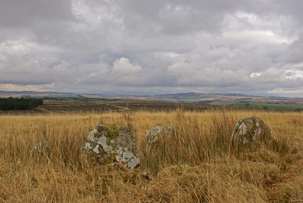
Looking towards the four poster from the ‘outlier‘


24-2-07
wolfy
24-2-07
although this is a very small setting , a 360 degree view can be seen.
wolfy

24-2-07
view from the possible outlying stone SW to the four stones.
wolfy

24-2-07
the track to the stones can be seen just to the right.
wolfy

24-2-07
The four stones with the possible outlying stone 13.5m to the NE.
wolfy

Viewed along the short side (2.4m)

Viewed along the long side (2.7m)
I have added Glenterrow Cairn, an almost destroyed cairn 50 metres SE of Glentirrow/Glenterrow Stone circle to TMA. All signs for the stone circle have been removed so after some trial and mostly error I would recommend the following route for visiting Glentirrow/Glenterrow Stone circle.
Directions: Take the New Luce turn off the A75 at the E end of Castle Kennedy village. After 3.5 miles there is a gateway on the L at NX 1478 6240. I would be cautious if there are beef cattle in the field as they can be dangerous. There is a farm track leading N at first then bearing NW into a gateway at a boggy corner. Go through the gate and head SW up the field parallel to the fence for 350 yards. Glenterrow Cairn is in the SW corner of the field. Glentirrow/Glenterrow Stone circle lies 50 metres NW in rough moorland and can be seen from the field corner.
Since I visited last year the sign to the stones has gone. There are now no further signs to the stones. If without GPS do not rely on the OS map to get your bearings when driving. The most distinctive feature in the vicinity, the forestry plantation to the north of the road to New Luce, has been significantly reduced to a rectangle away from the road. From the look of the stumps this happened at least ten years ago. So, to find the stones: park near the white ‘2M’ stone and go through the new bare metal gate after assessing the direction of the road there. This mirrors the direction of the longest approach part of the path to the stones. Head, as has been said before, for eighty metres or so along the path to where the first sign used to be. There you will find a little stream – or at least a muddy patch – and an area of bracken, sedge etc. Cross the stream and continue along the defined path across a section of resumed rough grassland for another hundred metres. For the last part of this section you will have an area of sedge on raised ground on your left/western side. When the sedge patch ends not continue ahead on the clearly defined path – this is the wrong direction. Instead, hug the edge of the sedge patch as it turns northwestwards and start to ascend the hill via an initially ill defined path...several little ruts. Soon this path becomes significantly more defined. It has two ruts, and is pretty straight. A wireless mast on top of a hill will come into view ahead, then, in line with it, you should see a gate at the far corner of the field. The path heads straight for this.The stones and their outlier should be seen poking out of the grass to your right very near the path about, I’d say, 120m before you get to the gate. Do not be tempted to say ‘aw, dinky! sweeeet!’ They are the height they are because they have sunk into the peat. What you see are just the stones tops. I have read a record of a stone row to the south which has sunk into the peat and vanished completely. This four poster is well on the way. I wouldn’t be surprised if it wasn’t initially a good five or six feet high. CAUTION: Be very careful when exploring the surrounds to the stones, or, indeed, anywhere away from the path as there are hidden drainage gullies over the entire area, which, I promise, could be ankle breakers. One nearly got me. Nonetheless, enjoy this peaceful place...lovely on a sunny evening. I saw several deer while there. I had a gingerly look to see if the drainage works had revealed any of the sunken stone row without success, and circumstances willing, will certainly return. Those visiting in, say, three hundred years may well find nothing.
No trouble at all finding this, which probably wouldn’t have been the case without the signpost and way-marked path! Although the stones are small, this is a perfectly formed little Four Poster with what would appear to be an attendant outlier as well.
The feeling of remoteness here is out of all proportion to the effort required to attain it, so this is well worth the effort if you subscribe to the theory that big isn’t necessarily always better. Perhaps it’s the minimalist in me, but I feel that often true quality is self evident.
The track actually continues to ascend a small hill bearing a prominent cairn.... but lack of time prevented a look this time around. More’s the pity.
There’s now (August 2006) a marked track leading to the circle from the gate into the field, near the 2M milestone SW of New Luce, so it’s much easier to find first time – no need for GPS! A sign at the gate reads: standing stones 500m. The first marker post is visible from the gate, right in front of you, at about 80m. Cross the burn and carry on following the same contour (north) to a second post about 100m further on. A third post should then be visible about 100m up the hill (west) and the ring is about 200m+ further on. At present, the circle is about 1 metre or so north of the track (on your right). If you reach the fence / gate then you’ve overshot by about 70m.
Burl describes this as “a delight to see”. I suppose it depends on your view on four-posters.
It must be one of the smallest (2.4m x 2.7m) and least imposing (in terms of stone size) of all stone circles so maybe that makes it distictive enough to want to see it.
There is another stone of the same size 12m NE.
Visited 1 March 2004


