|
|

|
|
Lancashire
|
|
|
|
Sites in this group:
|
7 posts
Anderton Cup and Ring Marks / Rock Art |
7 posts
20 sites Anglezarke Moor Group |
6 posts
Ashleigh Barrow Round Barrow(s) |
|
10 posts
Askew Heights Enclosure |
3 posts
Astley Hall Farm Bronze Age Burial Site Enclosure |
4 posts
Badger Hole Cave / Rock Shelter |
|
3 posts
Barrow Hill Kerbed Cairn |
1 post
Beadle Hill Ancient Village / Settlement / Misc. Earthwork |
5 posts
Bleara Lowe Round Cairn |
|
45 posts
Bleasedale Circle Timber Circle |
10 posts
Boar's Den Round Barrow(s) |
2 posts
Borwick Cairn Round Cairn |
|
2 posts
The Bride's Chair Natural Rock Feature |
1 post
Brock Hall Tumulus Artificial Mound |
1 post
Brown Hills Beck Barrow East Round Barrow(s) |
|
Brown Hills Beck Barrow West
Round Barrow(s)
|
8 posts
Brown Low Round Barrow(s) |
2 posts
Buck Stone Natural Rock Feature |
|
10 posts
Burwains Camp Enclosure |
Burwain's Farm
Stone Circle
|
2 posts
Cant Clough Ring Cairn |
|
4 posts
Carve Hill Round Barrow(s) |
16 posts
Castercliff Camp Hillfort |
9 posts
Castlesteads Hillfort |
|
5 posts
1 site Castle Hill (Leck) Ancient Village / Settlement / Misc. Earthwork |
5 posts
Charters Moss Ancient Village / Settlement / Misc. Earthwork |
38 posts
Cheetham Close Stone Circle |
|
3 posts
1 site Claughton Enclosure |
4 posts
Cliviger Law Cairn(s) |
19 posts
Delf Hill Stone Circle |
|
5 posts
Dog Holes Cave Cave / Rock Shelter |
5 posts
Ell Clough Ring Cairn |
5 posts
Extwistle Moor Stone Circle |
|
1 post
The Fairy Hole Cave / Rock Shelter |
9 posts
Fairy Holes Cave / Rock Shelter |
14 posts
The Great Stone Of Fourstones Natural Rock Feature |
|
13 posts
Hambledon Pasture Round Barrow(s) |
11 posts
Hanging Stone Natural Rock Feature |
6 posts
Hawksclough Hillfort |
|
11 posts
Hellclough Stone Circle |
2 posts
Holdens Farm Barrows Round Barrow(s) |
7 posts
Jacksons Barrow Artificial Mound |
|
10 posts
Jeppe Knave Grave Cairn(s) |
12 posts
Little Hameldon Long Barrow |
3 posts
Longridge Fell Cairn Round Cairn |
|
6 posts
Lower Heysham - Heysham Head Natural Rock Feature |
1 post
Mawdesley Blue Stone Standing Stone / Menhir |
10 posts
Mosley Height Stone Circle |
|
5 posts
Parlick Pike Cairn Round Cairn |
11 posts
Pendle Hill Sacred Hill |
2 posts
Pike Lowe Cairn(s) |
|
2 posts
Pleasington Cemetery Barrow / Cairn Cemetery |
4 posts
Portfield Hillfort Hillfort |
11 posts
Pots and Pans Stone Natural Rock Feature |
|
5 posts
Queen of the Fairies Chair Natural Rock Feature |
2 posts
Ravenstone Rocks Rocking Stone (Destroyed) |
8 posts
Revidge Round Barrow(s) (Destroyed) |
|
8 posts
Ring Stones Ring Cairn |
1 post
Ring Stones Hill Stone Circle |
3 posts
Round Hill Ancient Village / Settlement / Misc. Earthwork |
|
4 posts
Saddleworth Bowl Barrow Round Barrow(s) |
4 posts
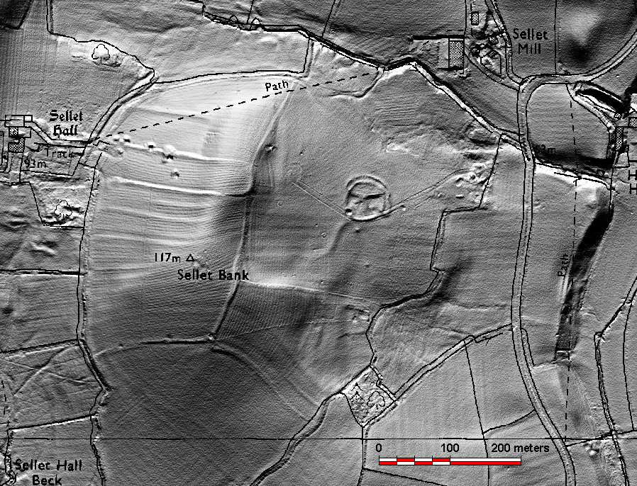
Sellet Bank Enclosure Enclosure |
9 posts
Slipper Lowe Ancient Village / Settlement / Misc. Earthwork |
|
6 posts
Standing Stones Hill Ring Cairn |
6 posts
Stump Cross Standing Stone / Menhir |
29 posts
Summerhouse Hill Round Cairn |
|
8 posts
Thirteen Stones Hill Stone Circle |
30 posts
The Three Brothers Natural Rock Feature |
9 posts
Torrisholme Round Barrow(s) |
|
6 posts
Twist Castle & Barrow Artificial Mound |
8 posts
The Two Lads Cairn(s) |
19 posts
Warton Crag Hillfort |
|
10 posts
Whitelow Cairn(s) |
12 posts
White Brow Cairn(s) |
1 post
Wild Bank Hill Round Cairn |
|
8 posts
1 site Winckley Lowes Round Barrow(s) |
14 posts
1 site Winter Hill Cairn(s) |
11 posts
Winter Hill Cairn Cairn(s) |
|
Worsaw Hill
Round Barrow(s)
|
9 posts
Worsthorne Hill Stone Circle |
5 posts
Wycoller Hall Cup Marked Stone |
Sites of disputed antiquity:
|
1 post
All Hallows Well Sacred Well |
4 posts
Cheetham Barrow Artificial Mound |
4 posts
Cross Gills Mound Artificial Mound |
|
6 posts
Moortop Barrows Round Barrow(s) |
News |
|
|
Significant artefacts found on Thornton site for homes https://www.bbc.co.uk/news/uk-england-lancashire-66809278 |
 Posted by The Eternal
18th September 2023ce |
Spot the Hunter-Gatherers!https://www.facebook.com/events/2128530017175633/ Got a spare day between Tuesday 6 and Sunday 11 March 2018? Join our survey team and help find Spodden Valley's ancient hunting camps... continues... |
 Posted by juamei
19th February 2018ce |
Pristine pressed flower among 'jaw-dropping' bronze age finds3,000-year-old complete pressed flower is among the “absolutely jaw-dropping” late bronze age finds unearthed in Lancashire. The thistle flower appears to have been deliberately placed inside the hollow end of an axe handle and buried with other weapons, jewellery and ornaments, many in virtually pristine condition... continues... |
 Posted by moss
3rd October 2016ce |
Bronze Age burial site uncovered in Lancashire fieldFrom the BBC... "A Bronze Age burial site uncovered after two metal detector enthusiasts found artefacts is set to be excavated. Matthew Hepworth and David Kierzek discovered a chisel and a dagger in a Lancashire field, 20 years after one of them first explored the site... continues... |
16th March 2016ce |
Dig Unearths Evidence Of A Bronze Age SettlementDig unearths ancient mine and Roman road Last posted: Friday 10 October 2003 12:10 ARCHAEOLOGISTS have unearthed evidence of a Roman road and Bronze Age settlement at a multi-million pound business and leisure park development... continues... |
 Posted by Jane
10th October 2003ce Edited 28th October 2003ce |
Folklore |
|
|
https://www.mysteriousbritain.co.uk/ancient-sites/weeton-cairn-boggart/ Weeton Cairn probably comes under a "site of disputed antiquity." Now also under the embankment of the M55. As for the boggart...... |
Posted by The Eternal 23rd July 2023ce |
Miscellaneous |
|
|
Lancashire and Lancaster (and Kirkby Lonsdale) take their names from the River Lune, which rises in Cumbria and flows for 44 miles to the Irish Sea. Speculative origins for the river's name include a Celtic word meaning "pure" and a possible derivation of a local Celtic God called Ialonus. [Added for Postie, better late than never!] |
 Posted by thesweetcheat
13th August 2012ce |
Druidical Rock Basins.From John Harland's 'Lancashire Folklore' (1867). http://www.archive.org/stream/lancashirefolklo00harl#page/106/mode/2up |
 Posted by Rhiannon
27th February 2012ce |
Links |
|
Transcription from a diary (1953-54)Just found this link to a diary of one of the founders of Chorley Archeology Society. In it he mentions finds from Anglezarke and the surrounding districts. |
12th November 2006ce Edited 12th November 2006ce |
Old Maps of LancashireThe County Council has done it again !. Unlike MARIO, this site gives access to a lagre collecton of maps covering the county. From general Lancasire maps such as Speed 1610, Lancashire Town maps c. 1890 to O.S. 1st Edition 6" maps c. 1845. A useful research tool! |
1st August 2003ce |
Northern EarthA site full of 'TMA' type material especially covering the North of England region. |
1st August 2003ce |
MARIO - Maps And Related Information OnlineA great research tool provided by Lancashire County Council that enables you to overlay and compare the current edition of O.S. map for Lancashire with the 1st edition O.S. map. You can also drop on aerial photograph layer to give you a better feel of the lay of the land. |
26th June 2003ce Edited 30th July 2003ce |
Latest posts for Lancashire |
Showing 1-10 of 842 posts. Most recent first | Next 10 
Black Hill Upper 1 (Cairn(s)) — Fieldnotes |
|
[visited 19/5/23] The hard slog but on a cloudless day with only skylarks and peewits for company, 101% worth it. That old top to bottom feeling of peace as I sunk down to eat my sandwiches. One of several small cairns poking out about the edges of the peat up here, ever more suggestive of a large cairn field under the blanked bog on the flat bits all the way to the top of hurst hill. This is a small site buried in the archaeological survey and well worth the effort if you like small mounds of stones. There is just a hint of a kerb, a few earthfast stones coquettish peaking up on the edges. Access is difficult across peat bog from any direction. I came from the great hill to hordern stoops footpath and its quite boggy. I left via Round loaf and across moor to lead mines clough. Quite boggy that way too! |
Posted by juamei 31st May 2023ce |
Black Hill Upper 1 (Cairn(s)) — Images (click to view fullsize) |
|
Posted by juamei 30th May 2023ce |
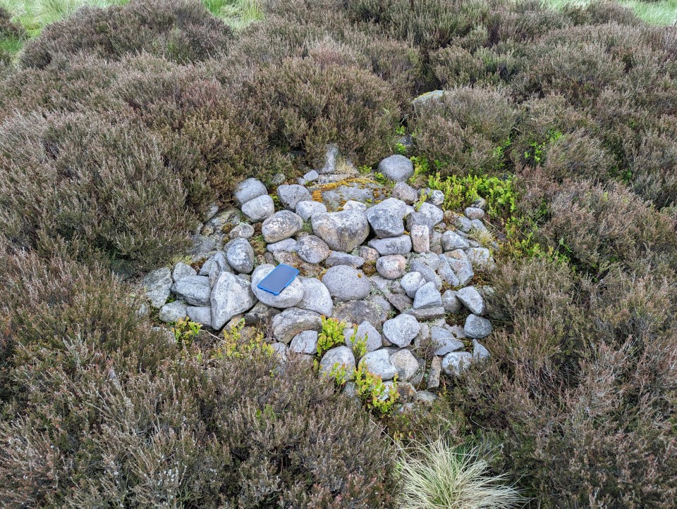
Black Hill Upper 1 (Cairn(s)) — Miscellaneous |
|
Site 16 in the Anglezarke and Rivington Moors - Archaeological Survey 1986. "This is a relatively well defined cairn in an area of peat erosion. It comprises small to medium field stones, some of which are earthfast. There is a possible kerb. It is in the vicinity of the PRN 4064 flake working area. Size: length 1.7m width 1.7m height 0" |
Posted by juamei 30th May 2023ce |
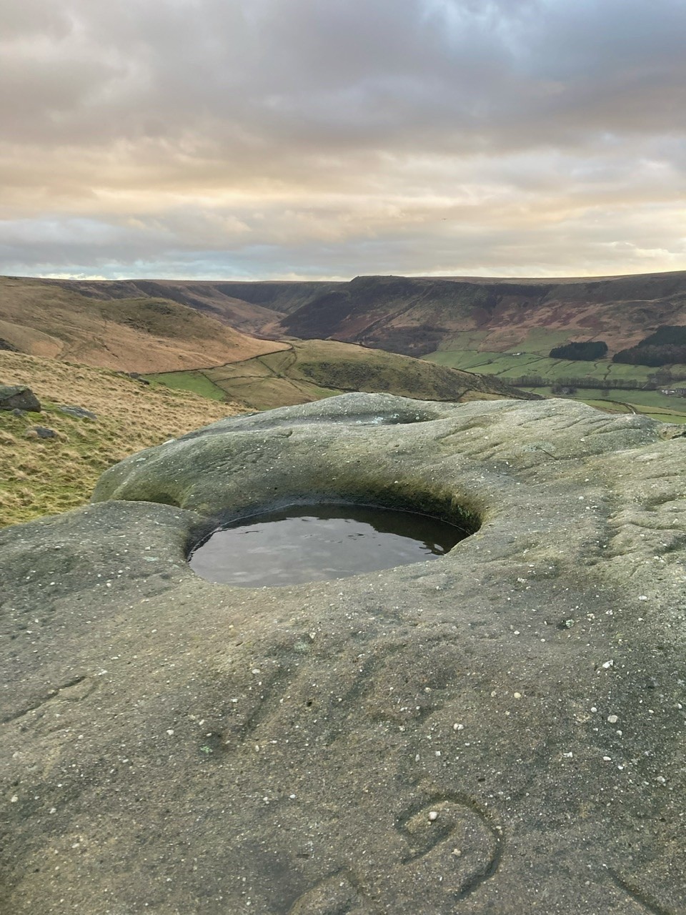
Pots and Pans Stone (Natural Rock Feature) — Images |
|
26th December 2022ce |
Hawksclough (Hillfort) — Images |
|
Posted by juamei 8th July 2022ce |
Hawksclough (Hillfort) — Fieldnotes |
|
[visited 7/7/22] Two hours to kill whilst waiting for guides to finish falling into a lake so I fired up the trusty map and spotted this nearby. I'm trying to see a few of these iron age sites nearby to validate a possible site I found on a local golf course, so this looked a good bet. I headed up from the south through the lovely old wood and eventually found the site. I have to say I'm not convinced on the ground and checking the lidar, I'm even less convinced. The ditches around the edges seem natural with some possible modification, but I'd expect a bank along the top, even slight, which seemed to be completely absent. There is obvious ridge and furrow across the top which you can see close up on the footpath and is picked out beautifully on the lidar, if I had to guess I'd presume the ditches at the foot of the slope were drainage for the mediaeval fields. On the way back I got deliberately "lost" in the woods, completely empty at 8pm. Bliss. Access pretty good from the south with only moderate rough ground and well maintained access roads and paths. Steep long grass at the site. |
Posted by juamei 8th July 2022ce |
Castercliff Camp (Hillfort) — Images |
|
Posted by nakers 23rd March 2022ce |
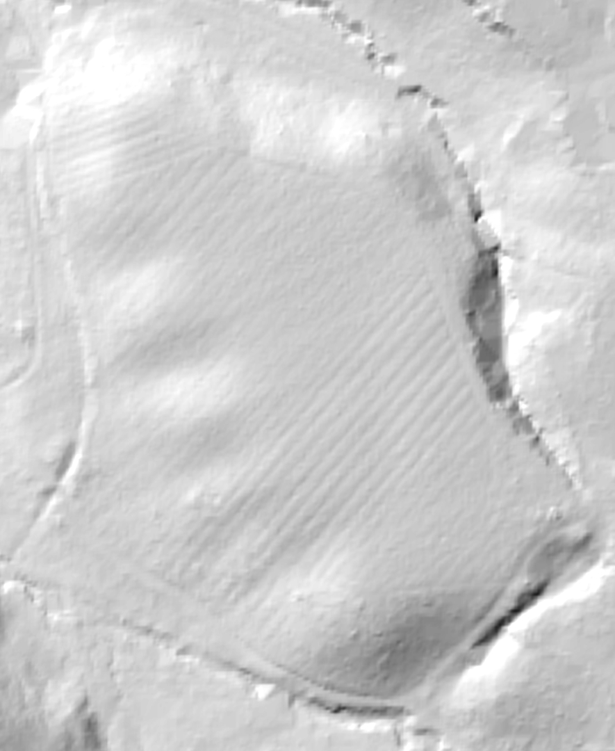
Sellet Bank Enclosure — Images |
|
Posted by Salister 20th July 2021ce |
Saddleworth Bowl Barrow (Round Barrow(s)) — Images |
|
13th December 2020ce |
Showing 1-10 of 842 posts. Most recent first | Next 10