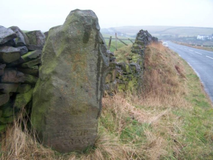
Log in
|
Register
Home
Latest Posts
Forums
Maps
Help
Browse Sites
News
Blog
Contributors
The Books
Select
-
Belgium
Denmark
Eire
France
Greece
Italy
The Netherlands
Norway
Portugal
Republic of Malta
Spain
Sweden
Switzerland
United Kingdom
England
Northern England
Lancashire
Stump Cross
Standing Stone / Menhir
Stump Cross (Standing Stone / Menhir) on The Modern Antiquarian, the UK & Ireland's most popular megalithic community website. 3 images, 3 fieldnotes, plus information on many more ancient sites nearby and across the UK & Ireland.
Image © treehugger-uk
Nearest Town:
Burnley (5km WNW)
OS Ref (GB):
SD877301 /
Sheet: 103
Latitude:
53° 46' 0.44" N
Longitude:
2° 11' 11.84" W
Added by
daveyravey
Images (3)
Fieldnotes (3)
0 discussions
Start a topic
Show |
Hide
Web searches for Stump Cross
Flash Earth
Flickr
Google
Google Images
MAGIC
The Megalithic Portal
Multimap 1:25000
Stone Pages
Streetmap.co.uk
Wikipedia
Show map
(inline Google Map)
- Sites within 20 km -
-
Mosley Height (0.41km ENE) (9 posts)
Cliviger Law (0.51km W) (5 posts)
Round Hill (0.61km NNW) (3 posts)
Hambledon Pasture (2.86km NNE) (13 posts)
Worsthorne Hill (2.91km NNE) (9 posts)
Ring Stones (3.03km NNE) (8 posts)
Cant Clough (3.17km ENE) (2 posts)
Twist Castle & Barrow (3.79km NNE) (6 posts)
Beadle Hill (4.27km NNE) (1 post)
Delf Hill (4.32km NE) (16 posts)
Pike Lowe (4.56km NNE) (2 posts)
Ell Clough (4.66km NE) (5 posts)
Mount Cross (4.71km ESE) (4 posts)
Hellclough (4.71km NE) (14 posts)
Extwistle Moor (4.79km NE) (5 posts)
Burwains Camp (5.67km NNE) (10 posts)
Burwain's Farm (5.8km N) (1 post)
Great Bride Stones (6.4km E) (13 posts)
Ring Stones Hill (6.76km N) (2 posts)
Standing Stone Hill (7.28km ENE) (6 posts)
Dove Stones (7.31km NE) (4 posts)
Sutcliffe Rough Standing Stone (7.35km ENE) (5 posts)
King Common Rough (7.53km ENE) (1 post)
The "Stones" Monoliths (7.98km ESE) (6 posts)
Blackheath Circle (8.02km E) (4 posts)
Blackheath Barrow (8.14km ESE) (0 posts)
Little Hameldon (8.31km WSW) (12 posts)
Castercliff Camp (8.32km N) (11 posts)
Stansfield Monolith (8.37km ESE) (2 posts)
Hippins Stone (8.8km E) (3 posts)
Bent Head (9.27km E) (4 posts)
Walshaw Dean (9.4km ENE) (20 posts)
Brink Ends Cairn (Dovestones Moor) (10.07km NE) (1 post)
Wycoller Hall (10.7km NE) (10 posts)
Slack Bottom Standing Stone (10.74km E) (3 posts)
Clam Bridge (Iron Age Bridge) (10.82km NNE) (5 posts)
Stoodley Pike Circle (11.18km E) (1 post)
Hanging Stone (12.44km NE) (3 posts)
Thirteen Stones Hill (12.49km WSW) (7 posts)
Cuckoo Stones, The (12.57km ENE) (9 posts)
Silver Hill (12.73km NE) (4 posts)
Midgley Moor CR-1 (13.06km ENE) (2 posts)
Midgley Moor CR-2 (13.06km ENE) (1 post)
Rudstoop Standing Stone (13.21km E) (2 posts)
Lower Apronful of Stones (13.28km WNW) (5 posts)
Two Lads (Withens Moor) (13.32km ESE) (6 posts)
Badger Wells Cairn (13.33km WNW) (5 posts)
Apronful of Stones (13.41km WNW) (6 posts)
Pendle Hill (13.43km WNW) (6 posts)
Midgley Moor CR-3 (13.45km E) (1 post)
Old Bess Stone (13.5km NE) (1 post)
Higher House Moor Monolith (13.7km ESE) (2 posts)
Wicken Hill (13.92km E) (3 posts)
Midgley Moor Standing Stone (13.96km E) (5 posts)
Jeppe Knave Grave (13.97km W) (11 posts)
Upper Lumb Stone (14km E) (2 posts)
Portfield Hillfort (14.12km W) (2 posts)
Robin Hood's Penny Stone (14.15km E) (4 posts)
Castle Carr Tombs (14.25km E) (2 posts)
Miller's Grave (14.25km E) (3 posts)
Churn Milk Joan (14.37km E) (8 posts)
Turley Holes Moor Standing Stones (14.45km ESE) (5 posts)
Midgley Moor (14.57km E) (3 posts)
Foster Clough Delph (14.85km E) (1 post)
Crow Hill Standing Stones (15.13km E) (1 post)
Crow Hill Cairn Circle (15.15km E) (1 post)
Whitelow (15.63km SSW) (9 posts)
Hare Hill Stone (Oakworth) (15.82km ENE) (2 posts)
Winter Hill Stone (15.9km NE) (4 posts)
Hitching Stone (Keighley Moor) (15.95km NE) (12 posts)
Bleara Lowe (16.04km NNE) (5 posts)
White Rocks (Luddenden) (16.42km E) (2 posts)
Robin Hood's Penny Stone (16.89km E) (2 posts)
Armshaw Lowe (17.38km ENE) (2 posts)
Tower Hill (17.99km E) (2 posts)
Rectory Allotment (18.23km NNE) (6 posts)
Loe Hill (18.31km W) (6 posts)
Winckley Lowes (18.48km W) (8 posts)
Castlestead Ring (18.51km ENE) (11 posts)
Carve Hill (18.82km SW) (3 posts)
Rishworth Moor (18.82km ESE) (2 posts)
Castlesteads (18.85km SSW) (8 posts)
Brock Hall Tumulus (19.22km W) (1 post)
All Hallows Well (19.36km WSW) (1 post)
Cross Gills Mound (19.7km W) (4 posts)
Cunt Stone, Keighley (19.96km NE) (5 posts)
- Facilities within 20 km -
-
middle beardshaw head ... (Camping Site: 8.4 km N)
Fox and Goose (Pub: 11.3 km E)
- Add -
-
Add news
Add an image
Add fieldnotes
Add folklore
Add miscellaneous
Add a link
-
Add a site
Add a nearby facility
Add an alternative name/spelling
Images
(click to view fullsize)
Add an image
Fieldnotes
Add fieldnotes
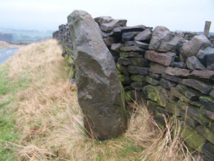
This stone seems far to close to Moseley Height i would think its an outlier to the great Circle that once stood in the field behind it.
This post appears as part of the weblog entry
Yule Be Disappointed
Comments (0)
|
Add a comment
|
Permalink
Posted by
treehugger-uk
3rd January 2006ce
Edited 4th January 2006ce
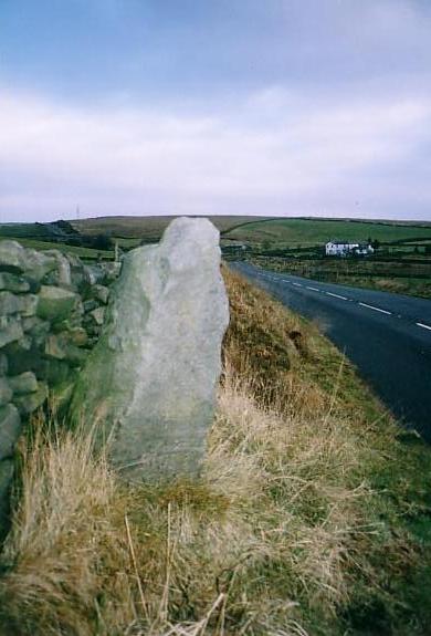
A 'possible' standing stone of the Bronze age.
Beware if you visit it - it's right by the side of a busy road, at the top of a hill, on a slight bend! Great views though :-)
The words 'Stump Cross' are just visible at the base of the stone.
Comments (0)
|
Add a comment
|
Permalink
Posted by
David Raven
12th June 2004ce
Very close to the site of Mosley Height. On the roadside embankment right next to the wall is a standing stone about 3 feet in height
Dave 25th November 2003
Comments (0)
|
Add a comment
|
Permalink
Posted by
daveyravey
26th November 2003ce
Edited 26th November 2003ce