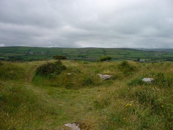
Extensive views north-east towards Zennor Hill, with many prehistoric field systems still in use.
Image credit: A. Brookes (18.6.2021)
Extensive views north-east towards Zennor Hill, with many prehistoric field systems still in use.

Granite tors on the summit ridge.

A circular arrangement of stones, which may be hut circle footings.

An area of burning on the southwestern side of the ridge has revealed lots of stone, some upright and some apparently in linear arrangements, although it’s very hard to see if anything here is the result of human activity.

Approaching from Nine Maidens Downs.

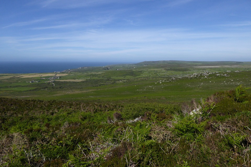
Looking southeast to the Nine Maidens ridge and the inevitable Ding Dong engine house. St Michael’s Mount, with the Lizard beyond, can just be seen far left.

The flat-topped headland immediately to the left of the rocky outcrops is Bosigran Cliff fort.

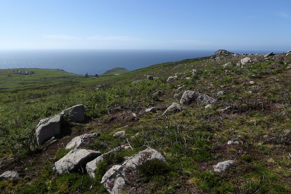
Looking northeast along the coast from the top of Carn Galva. There is an Iron Age courtyard settlement at Bosigran, approx. centre of image in the flat fields.

Rocky outcrops on the summit of Carn Galva.


From Nine Maidens Downs.

Carn Galva from the west, through mist and rain.

From the SE, a Cornish mini-Isandlwana.

Carn Galva with a cow using Men Scryfa as a scratching post in the foreground.

Carn Galva from Lanyon Quoit.

Taken from Zennor hill, during my unsuccessful quoit hunting...

From the path between Carn Galva and Hannibal’s Carn, August 1999.

Can Galva with the Nine Maidens in the foreground.

The view from Lanyon Quoit at dusk, the outcrop of Carn Galver masquerades as a smoking volcano.

Carn Galva looking out over towards Men an tol and Men scryfa

Tuesday 27th Jan 2004

Carn Galva – sorry, not a great pic, a bit of an after thought, with a great breaking sun that would look good in colour but hasn’t really shown up on black an white – 27.12.2002
Visited 14.4.10.
I parked in the car park outside the ruined Carn Galva Mine (N.T. site) and walked up to the top of Carn Galva along the obvious path. It was surprisingly quick to get to the top and only took me about 15 minutes. The views from the top are fantastic. You can see for miles along the rugged Cornish Coast and see Pendeen lighthouse in the distance. If you are physically able try to make the climb – you won’t be dissapointed.
With the weather forecasters telling us that the whole country was to be in the grip of an Ice Age by mid week I headed for subtropical St Ives. My partner had a two day conference to go to so I thought I would join her and get in some walking at the same time.
Tuesday 27th Jan 2004
Drove out of St Ives a couple of miles to the hamlet of Towednack. In the porch of the church on the right is a recumbent stone that according to Ian Cooke’s guide to the Tinners Way came from Crete in 2000-1500BC.
{{1,2,22}}
Left the church and took the footpath heading west to Beagletodn. Just after the house a gate on the right (padlocked) has to be climbed over so a track can be followed.
You will find in these two walks that I have not stuck to legal paths but made my own way over what is essentilly wild moorland. This is possible in mid January as the bracken has died down but even so I would reccomend wearing waterproof trousers and taking a stick.
The track twists its way amongst boulders and water features untill you come to a gate near the Pump House featured on the OS map. Go through the gate and turn right. You will soon find yourself walking up between two walls (not for the last time that you will be following ancient trackways). At the top of this track you come to another gate, once the other side of it it is time to head out over the moors towards Sperris Quoit.
{{3,4,5}}
Known as one of the most elusive sites in Cornwall I battled my way through the bracken and gorse in a north westerly direction untill I saw the pile of rocks on the skyline. Don’t be mistaken by Sperris Croft, a smaller pile but nethertheless named on the OS map.
Reaching the rock piles you will get great views over to the coast and also of Zennor Hill. The quoit lays just to the south of the rocks and can be distinguished by one triangular upright. Even from here it is not easy to reach and requires some scrambling amongst the stones. Keep an eye out for the ancient stone wall that runs off to the SEast, did they use stones from the quoit in its construction?
Leaving the rocks walk towards the ruined mine building. Wheal Sperris was a small mine started in the early 1800’s, all around this area are open shafts, water channels and various holes in the ground. If you do leave the path, beware, it’s pretty uneven ground.
Zennor Quoit looms on the horizon to the SWest and the path is easy to follow.
{{6,7}}
Once there I was undecided as to which way to go next, down to Zennor and the Tinners Arms, or onto other sites. The fact that I could see Mulfra Quoit on the horizon weighted my decision and I decided to head south along the old trackway before turning west to the Bishop’s Head and Foot boundry marker. This involved trudging through along muddy paths but the sense of space and the fact that the sun was shining made up for it. On the left hand side of the road beside Kerrowe Cottage is a stone with a nice carving on it, I don’t believe it tobe very old and judging by the “standing stones” opposit possibly a residents artwork.
Follow the tarmaced track to the road then carry on ahead to the “main” road. Cross the road and find the path that leads up over the northern saddle of Mulfra Hill. Yet again I decided to head out cross open moor and took myself off up the side of the hill. A couple of times I thought I had stuimbled across an unknown stone circle lying hidden in the gorse but decided my imagination was playing tricks. There is so much rock up there and at times you can trace a large arc between them, but never mind.
Eventually I picked up a path and found the quoit.
{{10,9}}
I could not have asked for a better view, the Lizard stood out clear as a bell, St Michael’s Mount sat below me and the sun caught the roofs of Newlyn giving them a silver coating. Time for a cup of coffee and a rest.
I suddenly realised time was getting on and I was far from the car. A footpath supposedly runs east from here down to the road but somewhere along the way I lost it and just plunged down the hillside dwarfed by boulders before reaching a forest of Rhododendrons.
I had thought of visiting the Tyre Menhir but time was getting on so I headed to Tyre Farm and turned left along another muddy footpath. Reaching a large Badger holt the path carries on cross a field to a gate beside a small pond (puddle!). In the next field a new fence has been eracted and the route of the path is not clear. However what is marked on the OS map as a round wall around a shaft interested me, is it just a round wall or is it a hillfort?
{{11}}
I climbed over the new fence at the far end of the field having decided there was no way through the hedge and skirted the pond before finding a rusty gate hidden in the undergrowth. It was impossible to open so I climbed over, disturbing a fox in the process. Turn left along the valley and you soon come back out onto the Kerrowe track, turn right.
THe simple way back from here is to follow the bridleway around the south side of Amalveor Downs to Embla Vean then by road to Towednack. I chose a slightly longer route heading more to the south but this did not include any sites of TMA interest except for a couple of tumuli sat overgrown in fields.
The walk took me about 5 hours including stops and it’s not just a trudge between quoits it’s a walk that offers lots more, space, views, and if like me you don’t meet anyone all day, solitude.
28th January 2004
Started day 2 at the carpark beside the engine houses of Carn Galver mine (on the B3306). It was here that my love affair with Penwith began. On a blustery day in Feb 1987 a friend gave me my introduction to rock climbing, if you want to get close to this landscape try hanging on to it by your fingers whilst the waves crash 200ft below you.
Today I head away from the sea, up the footpath/stream that runs along the west side of Carn Galver.
{{12,13}}
I have been up amongst the rocks before so today I carry on to the crest of the hill untill I come to a crossroads of paths. Turning right brings me to the field in which the Maen Scryfa stands.
{{14}}
Sadly the sun is right behind the stone so reading the inscription is not easy and photgraphing it impossible. I am struck by the contrast between lush green fields, stone walls and barren moorland. The dead bracken has turned much of the landscape a dull brown colour, only turning gold when the sun hits it at the right angle.
From the maen Scryffa it is a short walk to the men-an-tol, all is good there and after a short rest I carry on in the direction of Greenburrow Engine House (commonly known as Ding Dong).
Just after passing the little stream I noticed a pile of boulders on the right hand side. Amongst these and just beside the path is a square pit. Gorse and hawthorn grow out of it and it is full of water. I plunged my stick it and found it had a bottom, not far down. Like the “Hillfort” yesterday could this be an undiscovered cairn? or is it a mining relic, I will do some research and see what i can find out.
Ding Dong reached and explored (I wont bore you with mining details) I headed back towards Boskedndan circle.
{{15,16}}
The footpath is thin and runs through gorse and bracken but by following the wall I found my way to a cairn on the south end of the ridge. This lays buried amongst gorse, but with most of the other bracken etc dead it was possible to make out the stones that form the cairn.
The ridge runs north towards Carn Galvers mighty south peak and the stone circle is soon reached. It is rather a wet area in winter and a couple of times I was glad of my stick and high sides of my boots. I missed the standing stone but did explore the tumuli at the north end of the ridge before charging out across the moor to Little Galver, the rocky luump to the east. This was hard going! I wouldn’t reccomend it but I had decided I wanted to visit the quoit at Bosporthennis.
After a lot of hard work I reahed the walls that surround the quoit. Wow! this is a stoney landscape but imagine how many stones were used to build these walls? Up to 4ft thick inplaces and about 5ft tall we marvel at what it took to build the monuments but think how much work went into building these. And how old are they? who knows, some say the field patterns down here date back to the bronze age.{17,18,19,20}}
Having visited the quoit I head back to the road down another vague footpath before following the road back to the car. Looks like I am in time for a pint and a bowl of fish soup at the Gurnards Head
{{21}}
.
Carn Galva-where the giant ‘choone’ once lived!!, in my opinion a very evocative and powerful place!!...remains of ancient walls on the western peak suggest a settlement was here many moons ago!!..excavations from a ‘barrow’ that lies somewhere about the peaks revealed artifacts.Stand on the eastern peak and you can see for miles!!.’Men an Tol’ and the ‘Nine stones of Boskednan’, oh and ‘Men Scryfa’ stone are all but 10 mins walk!!...Truly amazing landscape!.
Beyond the Nine Maidens seaward is the great serrated range of granite rocks, Carn Galva, so conspicuous an object for several miles in nearly every direction. Somewhere amongst the rocks in this carn is the Giant’s Cave, in ages long gone by the abode of a giant named Holiburn. My informant could not point out the locality of this cave, her knowledge of it having been derived from hearing her “old man,” now dead, speaking about it some thirty or fourty years ago. It is of the rarest occurrence to hear the name of a giant mentioned in the recital of any oral tradition in this district; and, as a general rule, even those who best remember the stories current in their childhood have no recollection of ever having heard the giants alluded to by distinctive names.
From Rambles in Western Cornwall by the footsteps of the giants , by J O Halliwell (1861).
More about the giant who lived on Carn Galva:
Holiburn, according to tradition, was a very amiable and somewhat sociable gentleman; but, like his brethren, he loved to dwell amongst the rocks of Cairn Galva. He made his home in this remote region, and relied for his support on the gifts of sheep and oxen from the farmers around--he, in return, protecting them from the predatory incursions of the less conscientious giants of Trecrobben. It is said that he fought many a battle in the defence of his friends[...] I once heard that Holiburn had married a farmer’s daughter, and that a very fine race, still bearing a name not very dissimilar, was the result of this union.
So if you meet any exceptionally tall people in the locality, perhaps they could be a relation. From Hunt’s ‘Popular Romances of the West of England’ (1903, 3rd ed), online at the Sacred Texts Archive
sacred-texts.com/neu/eng/prwe/prwe010.htm
Hunt also heard from a man named Halliwell that “"Somewhere amongst the rocks in this cairn is the Giant’s Cave” where the giant lived.
A giant once lived at Carn Galva. (I’m warning you. This is another one of those depressing Cornish stories about giants. Don’t read it if you’re feeling delicate).
A giant once lived at Carn Galva, and he was a nice chap. He had a human friend from Choone, who used to take a turn over to the carn every now and then, just to see how the giant was getting on and to cheer him up a bit, or play a game. One afternoon they’d been playing quoits and when it was time for his friend to leave, the giant patted him on the head. “Same time tomorrow then?” But unfortunately the young man dropped down dead. The giant’s fingers had gone right through his skull. He tried to plug up the fingerholes, but it was a bit late.
“Oh, my son, why didn’t they make the shell of thy noddle stronger? A es as plum as a pie-crust, doughbaked, and made too thin by half. How shall I ever pass my time without thee to play bob and mop-and-heede?” And the poor giant was never happy after that. He pined away and died seven years later (probably the blink of an eye to a giant).
You can see how big the giant was, because his logan stone was just at the right height to sit on, with his feet comfortably on the turf below.
(story from William Bottrell’s ‘Tales and Hearthside Traditions of West Cornwall’ (c 1870?)quoted in Katherine Briggs’ ‘Folklore and legends of Britain’)