Looking along the eastern rampart. St Ives Bay and Godrevy Island over on the right.
Image credit: A. Brookes (23.10.2020)
Looking along the eastern rampart. St Ives Bay and Godrevy Island over on the right.

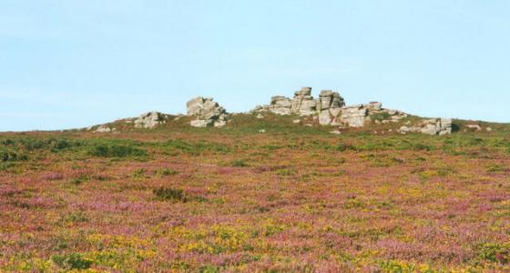
Lovely granite outcrop right in the middle of the interior.

Hut circle in the northern part of the fort.

In between the outcrops that divide the northern and southern parts of the interior. Trink Hill and Rosewall Hill, both with cairns, are the two hills on the left skyline.

Hut circle in the southern half of the fort.

Rock basin incorporated into the southeastern rampart. Looking south towards St Michael’s Mount.

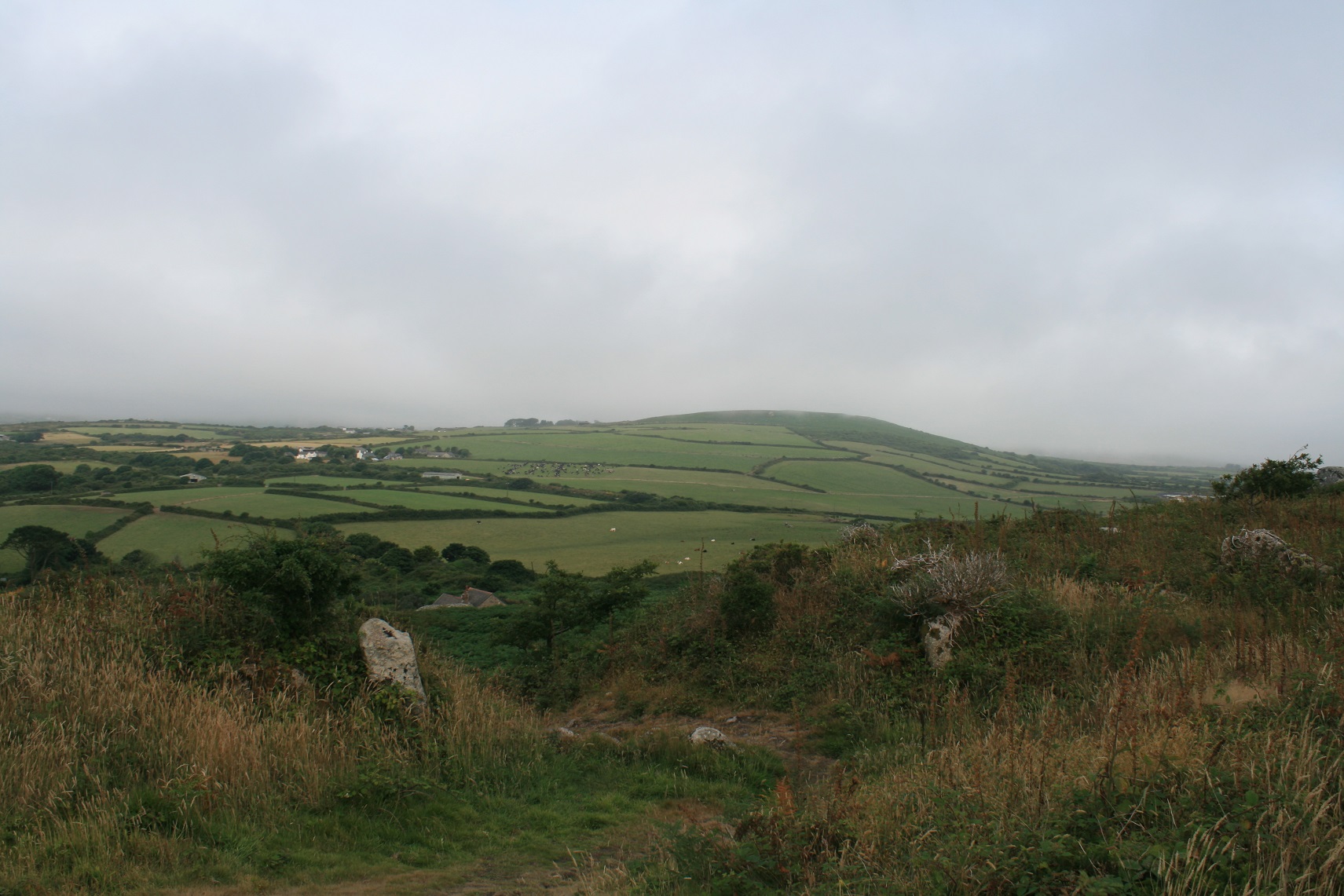
The southern end of the fort, looking WSW towards the neighbouring Castle-an-Dinas hillfort above Nancledra.

Trencrom seen from the creek below Phillack.

A weak rainbow greeted us as soon as we got to the top, path back to the carpark left through the rocks.
Looking north over the entrance and along the eastern rampart.

Rock basin on the southern edge of the fort, looking west-ish towards some kind of christianised island.

Rock basins on a Trencrom outcrop, perfect for two teenage kids and a dad with two dogs to sit in while watching the world go by.

Rocks in the fort, packed with fossils? (Criniods?)

looking south along the western wall towards St Mick’s mount.

The eastern entrance
The western entrance

Open Source Environment agency LIDAR


Natural basin in the granite inside the fort. Perhaps the floating roses are a Midsummer offering.

Gatepost, western entrance. The bright white colour on the upper half is lichen.

The western entrance, from outside.

Looking across the northern interior, Midsummer’s Day. Trink Hill (left) and Rosewall Hill (centre) each have barrows.

Fine hut circle within the fort. The neighbouring hillfort of Castle-an-Dinas can be seen on the skyline.

The eastern entrance.

General view of the interior. Hut circle in right foreground, St Michael’s Mount in the distance behind.

Hut circle remains, Trencrom Hill

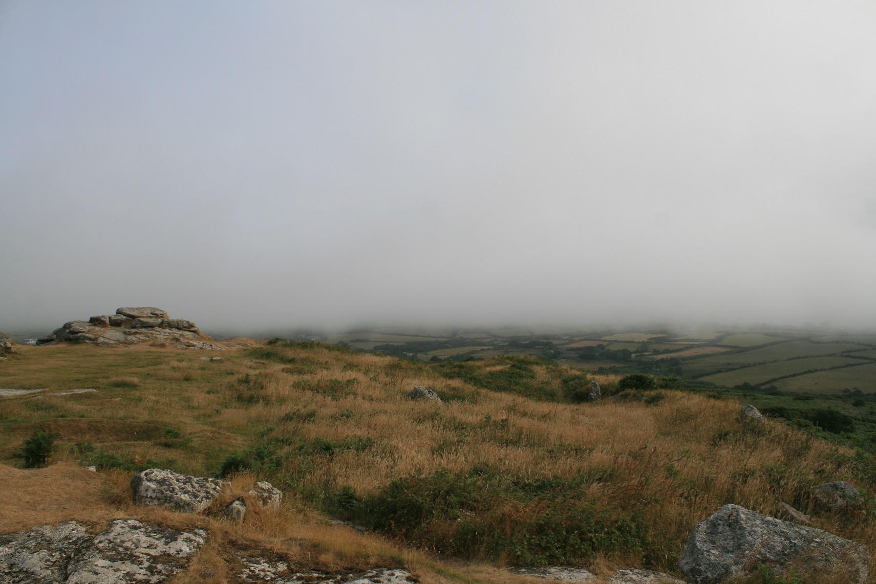
Trencrom, brooding in November mist and drizzle. Seen from the SW (footpath from Castle-an-Dinas to Nancledra).


Rock outcrop


View to Gwithian, Godrevy island and further up the coast. What I presume to be a rampart in foreground.

Wild foxgloves

You can see much of the Penwith peninsula from Trencrom, including Mount’s bay

The eastern approach to the hillfort.

The western inner rampart.

The northern inner bank and what appears to be a further one.

The eastern entance to the fort.

The hillfort from the south.

Trencrom as seen from Beersheba
Anyone for bob-buttons? Legendary giant mayhem at Trencrom Hill, near St. Ives, Cornwall
After a long and tedious motorway drive down the first thing we did was, well, it was book into the holiday village, then we went the chip shop, but after that we went straight up Trencrom hill.
Parking was had, funnily enough, in a car park on the south side of the hill, room for half a dozen cars or so, but this evening there’s just a van and us, us consisting of two older children, two Jack Russells and myself.
The way up is clear, but steep, big boulders abound, it’s not far to the top, once at the top we see the van driver flying his fast remote controlled plane. The view behind you as you climb up is one of St Micheal’s mount, so inevitably I whipped out the camera to take a shot at it. But the camera was dead, as dead as the proverbial. Disaster. I can only hope the camera has been turned on all the way here and all I have to do is recharge and start again. Pah.
We walk around, a touch despondent, and then head off to Beersheeba standing stone, with camera phones.
8am the morning after, daughter stayed in bed, Eric, dogs and me are back at the top, the plane flyer is gone but a rainbow has stood in as his replacement, rainbows are better.
From the southern walkers entrance we went over to the eastern entrance, a rather grand entrance with standing stones for gateposts, nice.
Then back to the highest rocks in the fort, there are basins here, three right next to each other, perfect for sitting in whilst watching the world doing it’s thing, or things, one of which is stirring the soul, sounds crap I know, but it’s never just about the stones, or in this case the fort, buddy at work is so narrow minded that he thinks this is just a hobby, it’s more a way of life.
Anyway, fully stirred, we continue to wander among the rocks, we didn’t wander too extensively, thus not seeing either of the two wells here about somewhere. Our limited wandering did expose the western entrance which I’d failed to note the evening before, another grand entrance with standing stones incorporated. Very nice.
Then we left, it’s time for breakfast, that, I think, was my first Cornish hillfort, I must see more.
So I do.
A great place to visit that has wonderful views in most directions. An especially good view south towards St Michaels Mt of which I have added a pic. Unfortunately views to the north are limited due to the lack of height that Trencrom has.
Easy to get to. Park in Trencrom village and it is an easy approach over a field and then up to the top with very limited ascent.
The fort itself is spectacular. It is easy to see why it was chosen as it has good 360 degree protection and offers decent views of the local area. The rocks also provide shelter in places. Trencrom is a very special place. You can feel the history in the air. Especially where the two stones show where the entrance into the fort was. Very serene, quiet and reflective place.
Definitely worth a visit.
Visited 10.4.10. This hillfort is very easy to access – only 5 minutes up from the car park with cracking views all around – although the path is quite steep and rocky. There are massive boulders all over this hill – including a huge square shaped one just before the ‘gateway’ stones. I returned to this site the following evening to watch the sun go down – beautiful.
Directions: Take the lane south of hillfort. Not far past Flax cottage (on the left) you will find the National Trust car park on your right. Through the gate directly in front of you, then follow the obvious path through the trees and up to the hillfort.
Scissorman is absolutely right, the views from this hillfort are some of the best you’ll see anywhere. It appears to be made up of a single rampart on the south and east sides where the land falls steeply away. The northern and western sides appears more complicated with inner and outer walls/banks and ditches.
The hillfort was donated to the national trust and is dedicated to the memory of all the women who died locally in WWII.
Trencrom Hill is always overlooked, yet provides incredible views over the whole of West Cornwall, with Mounts Bay to the south and St Ives bay to the north. The view to the East provides tremendous unspoilt views past carn Brea and on towards the clay pits.
The hill itself is an iron age hill fort. Park at the car park at the southern base of the hill, then walk along the bottm of the hill, keeping the hill to your left. The path will split and you must take the left hand route, which will lead you through bracken up the side of the hill. Hidden off to the left on your ascent is a sealed well, thought to have holy properties but now too dangerous to leave open, due to the depths it was sunk to.
Keep ascending until you enter the fort through a very obvious stone pillared gateway. There are exposed granite boulders in the settlement that proved wonderful seating for eating and viewing.
The remains of two huts can be seen sunken into the earth.
Take dowsing rods, as the reading here can provide great interest, with central energy flow coming from St Michaels Mount, through Trencrom and out towards Ireland. Smaller sources seem to track water flow around the hill.
A visit on a summers evening for sunset is a never to be forgotten experience.
Having already carried off the top of the neighbouring hill of Trencrom, to make the Mount [St Michael’s Mount] itself, Cormoran was in want of further stones wherewith to build his castle, and sent his wife to fetch them from the same place. She, thinking (womanlike) that any other stone would do as well, fetched this one from the nearer hill of Ludgvan-lees. Angry at her conduct, the monster slew her with his mighty foot, and the great rock rolled from her apron and fell where we see it now [Chapel Rock]; a silent witness to the lady’s strength and to the truth of the narrative.
From which I suppose we can conclude that the giant Cormoran thought Trencrom Hill had extremely good stone. And confusion about this merited murder. Or something. Anyway, I’d not heard this before, and it’s from Thurston C Peter’s ‘Notes on St Michael’s Mount’ in the Journal of the Royal Institution of Cornwall, v14 (1899-90).
About two miles from Colurrian is the fine and picturesque granite hill, Trecrobben, from the top of which are perhaps seen the most extensive views of the country to be met with in any spot in the whole district [...] The entrance into this enclosure from the Hayle side is in a tolerably perfect state, being nearly twenty feet wide, with large upright blocks of granite at the inner corners. Opposite to this, on the other side, is another entrance of a similar character. The large vallum does not form a perfect circle, but is turned out of its regular course in order to unite it with two carns, between which was another entrance nearly opposite Trink hill, and which we may call the principal gateway. On the largest of these carns are some rock-basons, known respectively as the Giant’s Chair, the Giant’s Cradle, and the Giant’s Spoon.
[...] Outside the vallum at Trecrobben, or, as it is called by the rustics, Trancrom, is the Giant’s Well; and on the fourth side of the hill is a large block of granite, known as the Twelve o’ Clock Stone, – a sort of natural sun-dial, on which the rays of the sun fall in such a manner, that the miners of the neighbourhood can tell the hour of noon by the direction of the shadows. There is another stone so called on the brow of Trink hill. About half-a-mile from Trecrobben hill, at Beersheba, is a large stone known in the neighbourhood as the Giant’s Bowl.
From Rambles in Western Cornwall by the footsteps of the giants by J O Halliwell (1861).
Not long since a tinner of Lelant dreamt, three nights following, that a crock of gold was buried in a particular spot, between large rocks within the castle, on Trecroben hill. The next clear moonlight night he dug up the ground of which he had dreamt. After working two or three hours he came to a flat stone which sounded hollow; whilst digging round its edges, the weather became suddenly dark, the wind roared around the carns, and looking up, when he had made a place for his hands to lift it, he saw hundreds of ugly spriggans coming out from amidst the rocks gathering around and approaching him. The man dropped his pick, ran down the hill and home as fast as he could lay foot to ground; he took to his bed and was unable to leave it for weeks.
When he next visited the castle he found the pit all filled in, with the turf replaced; and he nevermore dug for the treasure.
I think this is better and more frightening than Robert Hunt’s more flowery version. From Traditions and Hearthside Stories of West Cornwall by William Bottrell (1873).
A local newspaper, in 1883 (Cornishman), gives the following:-
“Superstitions die hard. -- A horse died the other day on a farm in the neighbourhood of St. Ives. Its carcase was dragged on a Sunday away up to the granite rock basins and weather-worn bosses of Trecroben hill, and there burnt, in order to drive away the evil spell, or ill-wishing, which afflicted the farm where the animal belonged.”
On p195 of
Cornish Folk-Lore. Part III. [Continued]
M. A. Courtney
The Folk-Lore Journal, Vol. 5, No. 3. (1887), pp. 177-220.
A lot of effort – so a deliberate effort to take it to a particular place? Or is it just that burning horses are very stinky.
Trencrom Hill was also used as a spot from which to throw stones at St Michael’s Mount:
In several parts of Cornwall there are evidences that these Titans were a sportive race. Huge rocks are preserved to show where they played at trap-ball, at hurling, and other athletic games. The giants of Trecrobben and St Michael’s Mount often met for a game at bob-buttons. The Mount was the “bob,” on which flat masses of granite were placed to serve as buttons, and Trecrobben Hill was the “mit,” or the spot from which the throw was made. This order was sometimes reversed. On the outside of St Michael’s Mount, many a granite slab which had been knocked off the “bob” is yet to be ‘found; and numerous piles of rough cubical masses of the same rock, said to be the granite of Trecrobben Hill, [a] show how eagerly the game was played.
Also from Hunt’s book, online at the sacred texts archive.
sacred-texts.com/neu/eng/prwe/prwe009.htm
Hunt mentions that “Trecrobben Hill still exhibits the bowl in which the giants of the west used to wash.” – so you may wish to keep your eyes open for this if you visit. This is presumably ‘The Bowl Rock’, on the stream to the NE, judging from the OS map.
On the summit of this hill, which is only surpassed in savage grandeur by Cam Brea, the giants built a castle--the four entrances to which still remain in Cyclopean massiveness to attest the Herculean powers by which such mighty blocks were piled upon each other. There the giant chieftains dwelt in awful state. Along the serpentine road, passing up the hill to the principal gateway, they dragged their captives, and on the great flat rocks within the castle they sacrificed them. Almost every rock still bears some name connected with the giants--“a race may perish, but the name endures.” The treasures of the giants who dwelt here are said to have been buried in the days of their troubles, when they were perishing before the conquerors of their land. Their gold and jewels were hidden deep in the granite caves of this hill, and secured by spells as potent as those which Merlin placed upon his “hoarded treasures.” They are securely preserved, even to the present day, and carefully guarded from man by the Spriggans, or Trolls, of whom we have to speak in another page.
From Hunt’s ‘Popular Romances of the West of England’ (3rd ed 1903). He mentions that Trencrom was also known as Trecrobben Hill.
sacred-texts.com/neu/eng/prwe/prwe008.htm
Another story about the Spriggans from Trencrom Hill can also be found amid Hunt’s book:
sacred-texts.com/neu/eng/prwe/prwe045.htm
and hinges on the slightly weird idea that the pixies would be counting their riches at a human’s house. The old woman who owned the house stole their money and moved to St Ives. Well that was her excuse for her sudden improvement in wealth at least. However, you can’t mess with the pixies: her comeupance was that one touched her clothes, and she had awful pains.
“It is not many years since a man, who thought he was fully informed as to the spot in which a crock of the giant’s gold was buried, proceeded on one fine moonlight night to this enchanted hill, and with spade and pick commenced his search. He proceeded for some time without interruption, and it became evident to him that the treasure was not far off. The sky was rapidly covered with the darkest clouds, shutting out the brilliant light o the moon--which had previously gemmed each cairn--and leaving the gold-seeker in total and unearthly darkness. The wind rose, and roared terrifically amidst the rocks; but this was soon drowned amidst the fearful crashes of thunder, which followed in quick succession the flashes of lightning. By its light the man perceived that the spriggans were coming out in swarms from all the rocks. They were in countless numbers; and although they were small at first, they rapidly increased in size, until eventually they assumed an almost giant form, looking all the while, as he afterwards said, “as ugly as if they would eat him.” How this poor man escaped is unknown, but he is said to have been so frightened that he took to his bed, and was not able to work for a long time.”
You have been warned.
from “Popular Romances of the West of England, collected and edited by Robert Hunt [1903, 3rd edition]”
as seen at the Internet Sacred Text Archive sacred-texts.com/neu/eng/prwe/index.htm