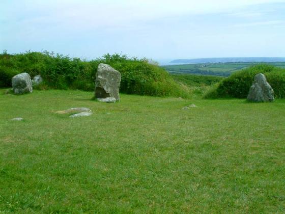
Totally destroyed, only a grass covered long depression remains.
Articles
The fuggo at Bodinnar, called the Giant’s Holt, was a few years ago much dreaded, as it was thought to be the abode of ugly spriggans that kept watch and guard over treasures which still remain buried in that ancient hiding-place.
From William Bottrell’s second volume of Traditions and Hearthside Stories of West Cornwall (1873), which you can read at the Sacred Texts Archive website.
Borlase’s description of the fogou:
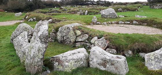
Bodinar Cave, called the Gyant’s Holt.
In the tenement of Bodinar, in the parish of Sancred, somewhat higher than the present village, is a spot of ground amounting to no more than half an acre of land (formerly much larger), full of irregular heaps of stones overgrown with heath and brambles. It is of no regular shape, neither has it any vestiges of Fortification.
In the Southern part of this plot, you may with some difficulty enter into a hole, faced on each side with a stone-wall, and covered with flat stones. Great part of the walls as well as covering are fallen into the Cave, which does not run in a straight line, but turns to the left hand at a small distance from the place where I entered, and seems to have branched itself out much farther than I could trace it, which did not exceed twenty feet. It is about five feet high, and as much in width, called the Giant’s Holt, and has no other use at present than to frighten and appease froward children.
As the hedges round are very thick, and near one the other, and the inclosures within them extremely small, I imagine these ruins were formerly of much greater extent, and have been removed into the hedges; the stones of which, appearing sizeable, and as if they had been used in Masonry, seem to confirm the conjecture. Possibly here might be a large British town (as I have been informed the late Mr. Tonkin thought), and this Cave might be a private way to get into or sally out of it; but the walls are every where crushed and fallen, and nothing regular to be seen;
I will only add, that this Cave, or under-ground passage, was so well concealed, that though I had been in it in the year 1738, yet, when I came again to examine it in the year 1752, I was a long while before I could find it.
From ‘Antiquities, historical and monumental, of the county of Cornwall..’ by William Borlase, published in 1769. ‘Froward’ is a real word by the way, it means contrary, ungovernable and generally naughty.
Oh wouldn’t it be great if this ‘destroyed’ place wasn’t really destroyed at all but was only hiding (like Higher Boden). If anyone knows what happened to it for sure...
Sites within 20km of Higher Bodinnar Fogou
-

Bosvenning Common
photo 10description 1 -
Chy-Gwidden Round
-

Wheal Buller Menhir
photo 10description 3 -

Botrea Barrows
photo 18description 1 -

Tremayne
photo 4description 3 -

Trewern
photo 4description 2 -

Boswens Croft
photo 35description 2 -

Trewern Round
photo 7description 2link 2 -

West Lanyon Quoit
photo 4description 5 -

Higher Downs
photo 2 -

Kerrow Bosullow
photo 1description 1 -

Chûn Castle
photo 52description 4 -

Lanyon Quoit
photo 111forum 1description 18link 1 -

Bosullow Trehyllys Courtyard House Settlement
photo 16description 4 -

Chûn Quoit
photo 85forum 2description 16link 1 -

Sancreed Beacon
photo 24description 2 -

Chûn
photo 2 -

Boslow Stone
photo 18description 2 -

Tregeseal Holed Stones
photo 57description 2 -

Sancreed Holy Well
photo 18description 13 -

Bosiliack Barrow
photo 46description 5 -

Portheras Common Barrow
photo 28description 3 -

Truthwall Common
photo 44description 2 -

Lanyon
photo 6description 1 -

Carn Kenidjack
photo 14description 4link 2 -

Tregeseal
photo 106forum 3description 19link 2 -

Hailglower Farm
photo 1description 1 -
Crofto
-

Caer Bran
photo 24forum 1description 3 -

Boswarthen Holed Stone
photo 3description 1 -

Ding Dong Lane
photo 11description 1 -

Burnt Downs Holed Stone
photo 2description 1 -
Trevowhan
description 1 -

Madron Holy Well
photo 18description 13 -

Men-An-Tol
photo 99forum 3description 43link 3 -

Carfury
photo 25description 5 -

Trevean Round
photo 7description 1 -

Higher Botallack
photo 3description 2 -

Bartinne Castle Enclosure
photo 11description 4 -

Carn Bean barrow
photo 4description 2 -
Carn Euny Fogou & Village
photo 113ondemand_video 1forum 2description 21link 4 -

St Euny’s Well
photo 22description 5 -

Tregeseal Entrance Grave
photo 10description 1 -

Venton Bebibell
photo 4description 1 -

Men Scryfa
photo 48description 13link 1 -

Boskednan Southern Cairn
photo 15description 2 -

Trengwainton Gardens
photo 2description 1 -

Nine Maidens of Boskednan
photo 115forum 4description 19 -

The Four Parish Stone
photo 7description 3 -

Trevean North
photo 5 -

Boskednan Cairn
photo 33description 4 -

Watch Croft
photo 35forum 1description 5 -

Watch Croft
photo 28description 2 -

Goldherring
photo 9description 1 -

The Giant’s Grave (Morvah)
photo 1description 1 -
Bosworlas Lehau
description 2 -

Brane
photo 30description 9 -

The Blind Fiddler
photo 51description 9 -

Little Galva
photo 4description 1 -

Brane Long Barrow
photo 7description 3 -

Lesingey Round
photo 17description 1 -

Tredinney Barrow
photo 19description 1 -
Numphra
-

Drift Stones
photo 44description 10link 1 -

Boscawen-Un hedge
photo 10description 6 -

Creeg Tol
photo 7description 5 -

Boscawen Menhir
photo 11description 2 -

The Selus Stone
photo 5description 1 -

Carn Galva
photo 23description 6 -

Chypraze
photo 14forum 1description 1 -

Bodrifty Reconstruction
photo 2forum 1description 1link 1 -

Bodrifty Iron Age Settlement
photo 22description 2link 1 -

Bosporthennis 'Beehive Hut'
photo 42forum 2description 8link 1 -

Hannibal’s Carn
photo 3description 1 -

Boscawen-Un (footpath)
photo 3description 2 -

Boscawen-Ûn
photo 113ondemand_video 2forum 6description 33link 4 -

Lower Boscaswell Fogou
photo 15description 4 -

Little Brea
photo 2 -

Mulfra courtyard houses
photo 13description 1link 1 -

Changwens Menhir
photo 3description 1 -

Bodrifty Barrows
photo 9description 2 -

Tom Thumb Rock
photo 3description 2link 1 -

Chapel Carn Brea North
photo 14 -

Bosigran Cliff
photo 30description 2 -
Ennis Farm
-

Chapel Carn Brea
photo 57ondemand_video 1description 9 -

Tresvennack Pillar
photo 18description 1 -

Botallack
photo 1forum 1description 1 -

Pendeen Vau
photo 26forum 1description 9 -

Mulfra Hill
photo 3description 1 -

Chapel Carn Brea long cairn
photo 13description 2 -

Bosporthennis Quoit
photo 21forum 2description 3link 1 -

Mulfra Hill round barrows
photo 19description 2 -

Mulfra Quoit
photo 78forum 1description 16 -

Trelew Menhir
photo 12description 3 -
Bosigran Settlement
-
Crankan courtyard settlement
-

Faugan Round
photo 8forum 1description 1link 1 -

Try
photo 3description 3link 1 -

The Beacon (Zennor)
photo 4description 1 -

Pridden
photo 2description 2 -

Kerris
photo 13description 3 -

Toldavas
photo 6description 2link 1 -

Porthmeor (Treen Common)
photo 17description 2 -
Porthmeor Fogou
-

Porthmeor
photo 20description 6 -
Porthmeor Roundhouses
-

Treen Entrance Graves
photo 26forum 1description 6 -

Chyenhal
photo 5description 2 -

Trevorgans Menhir
photo 17forum 1description 3 -

Tregiffian Vean
photo 14forum 1description 3 -

Rosemorran
photo 3description 1 -

Kenidjack Castle
photo 29description 4 -

Carn Gluze
photo 70forum 2description 9 -

Letcha
photo 9 -

Kenidjack Cairn Circle
photo 11description 1 -

Lescudjack Castle
photo 10forum 1description 4 -
Rosemorran Fogou
description 1 -

Trevedra Common
photo 1 -
Nanjulian
-

Trye
photo 1description 1 -

Sheffield Menhir
photo 3description 1 -

Boscregan
photo 26description 2 -

Redhouse
photo 5description 2 -
Chysauster Village
photo 78description 6link 1 -

Kerrow
photo 2description 1 -

Cape Cornwall
photo 14description 2 -

Pennance
photo 13description 3 -

Trevelloe Carn
photo 1description 2link 1 -

Gurnard’s Head
photo 40description 6 -

Conquer Downs
photo 10description 2 -

Paul Celtic Cross
photo 2description 1 -

Kerrowe Menhir
photo 4description 2 -

Escalls Cliff
photo 11description 2 -

Boleigh Fogou
photo 45forum 4description 16link 2 -

Alsia Holy Well
photo 7description 5 -

Tonkins Downs
photo 9 -

Castallack Round
photo 5description 3 -

Castallack Carn
photo 3description 2 -

The Pipers (Boleigh)
photo 87description 9 -

Castallack
photo 7description 2 -

The Merry Maidens
photo 110ondemand_video 1forum 2description 30 -

Castle-an-Dinas (Nancledra)
photo 26description 4 -
Trevear
description 1 -

Castallack 2
photo 6description 2 -

Gûn Rith Menhir
photo 43forum 2description 10 -

Tregiffian
photo 66description 14 -

Choone
photo 8description 4 -
Noon Digery banjo enclosure
-

Giant’s Rock
photo 7description 3 -

Foage
photo 5 -

Swingate
photo 2description 3 -

Treverven
photo 24description 3 -

Zennor Quoit
photo 74forum 3description 14 -
Merlin’s Rock and the Mousehole
description 1 -

Boscawen-Ros
photo 31ondemand_video 1description 4 -

Table Mên
photo 2description 2 -

Mayon Standing Stone
photo 3description 1 -

Kemyel
photo 3description 3 -

Sperris Quoit
photo 24description 3 -

Kemyel 2
photo 3description 1 -

Sperris Croft
photo 12description 3 -

Wicca Round
photo 1description 1 -

Sennen
photo 2description 3 -

Mayon Cliff
photo 28description 4 -

Maen Castle
photo 42ondemand_video 1description 3 -

Trendrine Hill
photo 18description 3 -

Towednack Double Armed Cross
photo 2description 2 -

Treryn Dinas
photo 49ondemand_video 1forum 1description 15 -

St. Michael’s Mount
photo 18forum 1description 10 -

Trink Hill
photo 5description 4 -

Pordenack Point
photo 18description 2 -

St. Levan’s Stone
photo 8description 5 -

St. Levan’s Well
photo 7description 1 -

Carn Les Boel
photo 25ondemand_video 1description 3 -

Rosewall Hill
photo 6description 3 -

Trencrom Hill Well
photo 3description 1 -
Roskestal West Cliff
description 1 -

Trencrom Hill
photo 42ondemand_video 1description 13 -

Giant’s Well
photo 1description 1 -

The Bowl Rock
photo 4description 4 -

Beersheba
photo 9description 5 -

Carbis Bay Longstone
photo 5description 4 -
Treveneague Fogou
forum 1description 2 -

The Fairy Well
photo 6description 3 -

Cudden Point
photo 1description 1 -
St Erth Round
-

Carnsew
photo 9 -

Phillack Towans
photo 4description 1 -
Castle Kayle
-

Godolphin Hill
photo 6description 1link 1 -

Castle Pencaire
photo 25forum 1description 3 -

Trewavas Cliff
photo 14description 3 -

Tregonning Hill
photo 11 -

Camel Rock
photo 5description 1