
Remains of a retaining kerb on the northwestern side of the cairn to the southeast of the enclosure.
Image credit: A. Brookes (22.6.2019)
Remains of a retaining kerb on the northwestern side of the cairn to the southeast of the enclosure.

Overgrown and badly damaged cairn on the southeastern slopes of Bartinne Downs.

The southeastern of the three ring cairns, very overgrown and difficult to see properly.

The northeastern of the three ring cairns inside the enclosure.
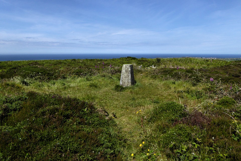
The well-defined western ring cairn.

The western ring cairn inside the enclosure.

Stone-lined pit inside the enclosure, which Craig Weatherhill identifies as a miner’s prospecting pit rather than a well.

The northwestern arc of the enclosure bank.

The overgrown bank of the enclosure.

Inside the Bartinne enclosure

Barrow near Bartinne enclosure, looking towards Chapel Carn Brea
On the next hill, the dreary one of Bartinney, is a monument of somewhat similar description [with a vallum and ditch], but it is in a sad state of ruin and nearly overgrown with turf and furze. The wide vallum that surrounded it can, however, be distinctly traced, as may be also the three circular enclosures near the centre, all mentioned and figured by Borlase.
There is a tradition that there were rows of seats on the inner side of the vallum, and that games or plays were performed in the centre.
According to another, hence came the giants of Bosworlas Lehau, when they were inclined for a little recreation.
From Rambles in Western Cornwall by the Footsteps of the Giants by J O Halliwell-Phillipps (1861).
A third theory (see below for the other two) could be formed from a tradition heard by J.O. Halliwell and repeated in his book ‘Rambles In Western Cornwall’. This held that the bank was formerly higher, with its inner slope fashioned into rows of rough seating, similar to the medieval ‘Plen-an-gwarys’ [medieval ampitheatre]. If this was not the result of a later re-use of the site, the possibility exists that Bartinne was a sacred enclosure; indeed, legend tells us that no evil spirit can enter it. Fires were lit during the worship of the Celtic sun-god Belenos and it is worth noting that the name Bartinne has been interpreted as deriving from the Cornish ‘bre tanow’ -hill of fires.
I found the numerous paths confusing so; to reach Bartinney/Bartinê/Bartinne (there are numerous spellings of it) Castle from Chapel Carn Brea car park: the path forks almost immediately after the wooden gate. Take the right fork with ‘Danger Mine Shafts’ sign, through a pair of granite gate posts. Continue all the way along the bottom of the hill, with overgrown mine workings on either side, until just before another wooden gate (St Euny Holy Wells are just on the other side in the trees). Take the path on the left heading straight up. Go over a wooden stile and eventually over a stone stile. When you come to a ‘cross roads’ take the path closest to straight ahead. The pillar/summit will soon be seen on your right. The views are tremendous, on a par with nearby Trencrom Hill. For an alternative/more direct route back (or there of course): at the ‘cross roads’ take the right path, through the remains of a wall, ignoring minor paths leading off, bearing left when the main path forks. You will soon see a path on the left heading towards open, grassy land. Take this one, cross the wooden stile a hundred yards or so to the left, then turn right. This path crosses Tredinney Common and will return to the original path. It is less ‘pretty’ than the route there but handy if the weather closes in!
Can be reached from many directions, the best of which might be from the track opposite the car park at the foot of Chapel Carn Brea then across Tredinney Common, keeping the disused china clay works on your right. Alternatively approach from Carn Euny.
This is what Craig Weatherhill says in his book ‘Belerion: Ancient Sites of Land’s End’ (Cornwall Books, 1981)...“On the summit of the hill is a circular area 75m across, marked out by a low bank of earth and scattered stones, which is nowhere more than 0.9m high. A shallow encircling ditch has virtually disapppeared. In the centre of the enclosure are three small circular banks of earth and gravel arranged in a tight triangular plan; the edges of two actually join. There is no sign of the ‘continuous stones pitched on end’ mentioned by Dr Borlase. The largest and best preserved of these circles, now containing the OS triangulation pillar, is 11.8m in diameter; the others are 7.9m and 9.1m across. Whether they are the remains of hut circles or ring barrows is not yet known.
What Bartinne Castle actually was is also a mystery. Even though the enclosing bank has been extensively robbed, it seems that it was never strong enough to have been of any defensive value. Perhaps, as Dr Borlase suggested, it was a hill fort, traced out, begun, but never finished. It could be that an alternative site was found at Caer Bran on the next hill. Another suggestion is that Bartinne may have been a huge disc barrow.


