From TA Falcon’s ‘Dartmoor Illustrated’ (1900).
From TA Falcon’s ‘Dartmoor Illustrated’ (1900).


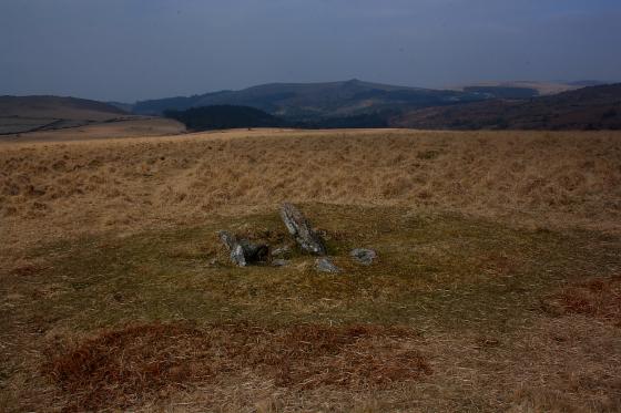
Wide open skies above Langstone Moor.


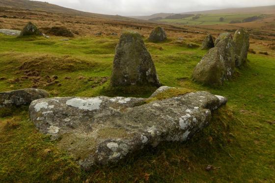
Although ‘restored’ to some extent – one wonders how trashed it was before – this is nevertheless an evocative site. A passing walker reckoned it was vandalised by American GIs during WWII....

4th August 2003

4th August 2003

After 2 failed attempts to reach this circle, 1st time by an incredibly thick fog, and 2nd time by gale force winds, i finally made it there on a glorious day. 3rd time lucky for sure.

A clear sign to the military!
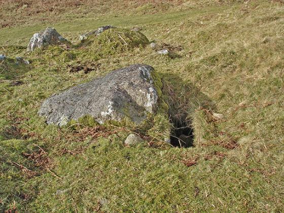
One of the many broken stones, due to the circle being on military training ground. Apparantly a tank was driven through the circle in the middle of the night.

An overall photo of the circle taken on a warm summer day.

Although less than a kilometre away as the crow flies, and clearly visible from Langstone Moor Stone Row, this runied circle requires some dedication to reach it. “Crossing’s Guide to Dartmoor” published in 1912 warns of the dangers of the bog on PeterTavy Great Common – a warning which is still valid today! A splendid view of the Great Mis Tor, the local ponies, cattle and an ominous looking “murder” of crows (who were just hanging out at trhe circle when we arrived) is afforded from the circle. It is now in a sorry state runied once and then re-erected by the miltary and now little under 100 years later it’s been ruined by them once again.
The remote Langstone Moor is located on the edge of the Merrivale Firing Range “Danger Area”, and thus is inaccessible at certain times of the year. To access the Moor you’ll need to be prepared to walk for more than 90 minutes from your car – if parked at Peter Tavy – or to get up out of the saddle of your Mountain Bike. The area is dominated by White Tor (468 metres above sea level) to the West and the Great Mis Tor (538) to the south. The walk to the foot of White Tor past Stephen’s Grave (marking the cross-roads burial spot of a suicide victim who killed himself when he discovered his betrothed had been unfaithful to him) is a well defined track littered with spent bullets. After that the footpath becomes more indistinct. You’ll need a map with you and a compass in case of bad weather. Langstone Moor Circle comes into view on then right but do not attempt to walk directly there from the footpath – there’s a very sticky bog in the way! The tall standing stone marks the eastern end of a poorly defined row. Both the stone and the circle were re-erected in 1894 but both have suffered from damage caused by military operations on the Moor. The poorly defined “Lich path” which cuts across Langstone Moor continues eastwards towards Conies Down and Beardown Man standing stone.
Details of stone circle on Pastscape
(SX 5565 7820) Stone Circle (NR) (1)
The Langstone circle, diameter about 56 feet, was discovered in 1894 and restored. It consists of 16 stones, two of which are of fine sandstone, the remainder of ordinary moor-stone. There appears to have been an outer circle of which 3 stones remain on the west side (2). Only two stones of the outer circle remain in position, the third being broken and the pit-hole visible. These stones are described as being a fine-grained stone, and only one of the inner stones of this material. Diameter given as 67 feet (4). Visible on air photographs. (2-5)
On the flattish top of Langstone Moor at approximately 452.0m OD is the remains of a restored stone circle. It is ovoid, 21.0m by 19.0m, with irregularly placed stones of which four are erect, six fallen and the remainder reduced to stumps. They average 1.0m high and 0.5m square. The interior is devoid of detail. One erect stone of similar dimensions remains of the outer circle on the south west side, 3.0m outside the circle. The number of irregularly positioned shallow pits in the vicinity makes further identification of the outer circle indefinite. Revised at 1:10 000 on PFD and at 1:250. See ground photograph. (6)
The circle is located on the southern side of the flattish summit of Langstone Moor ridge at an altitude of 455m above OD. The site is overlooked by Great Mistor to the South and Wittor to the North and has views of Roos Tor and Staple Tor further down the ridge and the Walkham valley at Merrivale. The view to the east is slightly restricted by the rise of Cock’s Hill.
Of the 16 stone of the restored circle only 11 now remain in-situ, though several of these are much shorter than they appear in Burnard’s 1894 photograph, including five which can only be described as stumps. The tallest stone today stands to only 1.1m high though Burnard recorded stones of between 5 and 6 feet (1.5 – 1.8m). Fragments of the broken stones lie scattered on the ground around the erect stones. There are also five stones that are completely toppled . Of the two stones said by authority 3 to be outside the main circle, only one remains on the west side and stands to 0.7m high. Some remedial work was recently carried out by the DNPA, during which erosion hollows around four of the stones were filled. Small hollows outside the circle may be ordnance impact craters.
As planned the stones form a far from perfect circle. Although it is possible that in its original form the monument was an imperfect circle, this seems unlikely and it is perhaps more credible that the stones were re-erected incorrectly.
The Stones
1. Standing intact, 1m high. Erosion hollow recently restored.
2. Stump 0.5m high on rebuilt concrete base. Top section lying on ground in 3 pieces.
3. Stump 0.45m high. Top section lies alongside. Original height c. 1.8m.
4. Stump 0.2m high. Three small fragments on ground beside.
5. Ground level stump. Top section on ground beside, 1.2m long.
6. Fallen slab 1.6m long plus fragments.
7. Stump 0.3m high plus shattered pieces.
8. Stump 0.4m high plus shattered pieces.
9. Standing intact, 1.1m high. Erosion hollow recently restored.
10. Fallen slab 1.5m long.
11. Edge-set slab, 0.7m high. Loose.
12. Fallen slab 1.25m long.
13. Fallen slab 1.35m long.
14. Standing, 0.9m high. Erosion hollow recently repaired.
15. Fallen slab 1.85m long plus shattered pieces.
16. Standing, 0.9m high. Splintered top section. Erosion hollow recently repaired.
17. Fallen 1.25m long.
According to Paul Pettit in “Prehistoric Dartmoor” IBSN 0-9515274-6-0
During World War II this monument was wrecked by troops traing on the moor. Today ONLY six stones stand to their full height . Four are fallen and broken; six are sad looking stumps, their tops deliberately knocked off and lying on the ground nearby. One substantial stone outside the circle remains a mystery. The magnificent site 1,450ft up can still be appreciated.