Skip to content
Julian Cope
presents
The Modern
Antiquarian
Latest
Posts
Sites
Map
Blog
Forum
search
Search
⚠️
Sign in
more_horiz
United Kingdom
England
Southern England
Devon
Dartmoor
Bude Farm Sticklepath
Standing Stone / Menhir
SX631947
expand_more
Nearest town:
Okehampton (4km W)
OS reference:
SX631947
OS sheet:
191
Latitude:
50° 44' 6.55 N
Longitude:
3° 56' 24.81 W
Added to TMA by
Meic
Images (1)
Add
content
Images
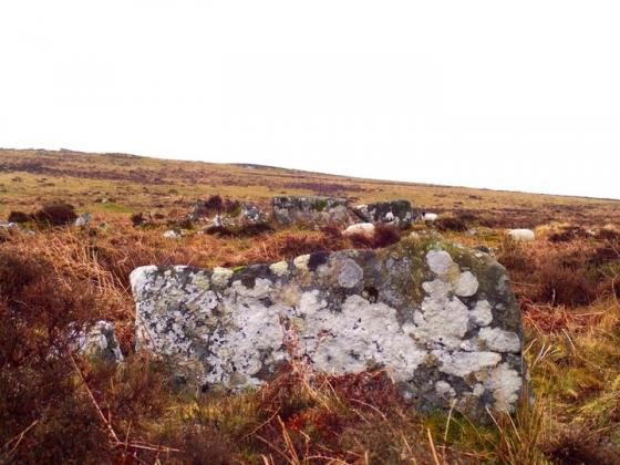
inscribed Stone nr Bude Farm
Image credit: Michael Mitchell
Meic
Oct 28, 2006
Sites within 20km of
Bude Farm Sticklepath
Watchet Hill
Barrow / Cairn Cemetery
•
2.26km SW
photo
6
Oxenham Arms
Standing Stone / Menhir
•
2.33km E
photo
4
forum
1
description
2
link
1
Nine Stones
Cairn(s)
•
2.68km SW
photo
27
forum
1
description
5
link
1
East Hill
Hillfort
•
2.76km WSW
photo
11
description
1
Cosdon Hill
Stone Row / Alignment
•
3.23km SE
photo
32
description
5
link
1
Cosdon Beacon
Cairn(s)
•
3.24km SSE
photo
4
Cullever Steps
Cairn circle
•
3.58km SW
photo
6
Higher Tor
Round Cairn
•
3.89km SSW
photo
7
White Hill
Ancient Village / Settlement / Misc. Earthwork
•
4.11km S
photo
20
description
1
White Moor Stone Circle
Stone Circle
•
5.1km SSE
photo
35
forum
1
description
11
Throwleigh (b) circle
Stone Circle
•
6.33km SE
description
1
Buttern Hill Stone Circle
Stone Circle
•
6.45km SE
photo
29
description
5
Buttern Hill Chambered Cairn.
Chambered Cairn
•
6.68km SE
photo
8
description
2
Yes Tor
Cairn(s)
•
6.79km SW
photo
23
description
2
link
1
High Willhays
Cairn(s)
•
7.3km SW
photo
11
description
3
Longstone Hill
Cairn(s)
•
7.45km SW
photo
5
description
1
Scorhill
Stone Circle
•
7.68km SE
photo
69
forum
3
description
12
Fordsland Ledge
Cairn(s)
•
7.79km SW
photo
18
description
4
Tolmen Stone
Holed Stone
•
7.96km SE
photo
4
The Spinsters’ Rock
Dolmen / Quoit / Cromlech
•
7.99km E
photo
40
description
10
link
1
Kes Tor
Ancient Village / Settlement / Misc. Earthwork
•
8.59km SE
photo
6
description
1
Puggie Stone
Natural Rock Feature
•
8.82km ESE
description
1
Shovel Down
Stone Circle
•
9.13km SE
photo
2
description
1
Whitehorse Hill
Cist
•
9.32km S
forum
1
description
6
link
1
Shovel Down & The Long Stone
Multiple Stone Rows / Avenue
•
9.36km SE
photo
62
forum
1
description
7
link
1
Corn Ridge
Barrow / Cairn Cemetery
•
9.66km SW
photo
19
ondemand_video
1
forum
1
description
1
Sourton Tors Circle
Stone Circle
•
9.8km WSW
photo
3
description
1
Bow Henge
Henge
•
10.28km NE
description
1
Fernworthy stone row (North)
Stone Row / Alignment
•
10.66km SSE
photo
15
forum
1
description
3
link
1
Fernworthy
Stone Circle
•
10.83km SSE
photo
54
description
6
link
2
Fernworthy Stone Row (South)
Stone Row / Alignment
•
10.86km SSE
photo
7
description
2
Fernworthy SE
Cairn(s)
•
10.87km SSE
photo
2
description
1
link
1
Fernworthy Cairn and Cairn Circle (Eastern)
Cairn circle
•
10.88km SE
photo
5
description
2
Thornworthy Down
Cist
•
10.99km SE
photo
12
description
1
Metherall Settlement
Ancient Village / Settlement / Misc. Earthwork
•
11.31km SE
photo
12
description
2
East Lowton settlement
Ancient Village / Settlement / Misc. Earthwork
•
11.54km SE
photo
17
description
1
The Greywethers
Stone Circle
•
11.62km SSE
photo
63
forum
4
description
11
link
3
Chagford Common
Ancient Village / Settlement / Misc. Earthwork
•
11.63km SE
photo
3
Fernworthy Round House
11.63km SE
photo
19
description
1
Great Links Tor
Round Cairn
•
11.64km SW
photo
10
ondemand_video
1
description
1
Heath Stone
Standing Stone / Menhir
•
11.69km SE
photo
1
description
1
Great Nodden
Cairn(s)
•
11.75km SW
photo
4
Sittaford
Stone Circle
•
11.89km SSE
photo
14
forum
1
description
1
link
1
Cranbrook Castle
Hillfort
•
12.09km E
photo
11
description
1
Meacombe Burial Chamber
Burial Chamber
•
12.18km ESE
photo
10
description
4
Sittaford Tor hut circles
Ancient Village / Settlement / Misc. Earthwork
•
12.22km SSE
photo
3
Prestonbury Castle
Hillfort
•
12.35km E
photo
16
description
1
Cut Hill
Stone Row / Alignment
•
12.41km S
photo
12
description
4
Assycombe Hill
Stone Row / Alignment
•
12.45km SE
photo
33
description
3
West Vitifer
Cairn(s)
•
12.77km SE
photo
2
Hurston Ridge
Ancient Village / Settlement / Misc. Earthwork
•
12.89km SE
photo
3
Hurston Ridge
Stone Row / Alignment
•
12.98km SE
photo
17
forum
1
description
2
link
1
Doe Tor
Cist
•
13.22km SW
photo
5
description
1
Shapley Common
Platform Cairn
•
13.62km SE
photo
12
Stannon Newtake
Cist
•
13.88km SSE
photo
1
description
1
East Bovey Head
Ancient Village / Settlement / Misc. Earthwork
•
13.89km SE
photo
14
description
1
Broad Down Cairn
Cairn(s)
•
13.95km S
photo
2
description
1
Water Hill
Ancient Village / Settlement / Misc. Earthwork
•
14km SE
photo
1
Water Hill
Cairn(s)
•
14.06km SE
photo
2
Birch Tor
Cairn(s)
•
14.19km SE
photo
13
description
1
Wooston Castle
Hillfort
•
14.29km E
photo
13
description
1
link
1
Shapley Tor
Cairn(s)
•
14.57km SE
photo
6
Challacombe
Multiple Stone Rows / Avenue
•
14.95km SE
photo
19
description
2
Roundy Park settlement
Ancient Village / Settlement / Misc. Earthwork
•
15.01km SSE
photo
3
Roundy Park
Cairn(s)
•
15.01km SSE
photo
16
description
2
Giant’s Grave (Dartmoor)
Long Barrow
•
15.17km E
photo
13
forum
1
description
2
Burley Camp
Hillfort
•
15.17km WSW
photo
1
description
1
Gallows Hill
Round Barrow(s)
•
15.17km SW
photo
1
description
1
Chittaford Cairn and Cist
Cist
•
15.22km SSE
photo
8
description
2
Mardon Down Cairn Circle
Cairn circle
•
15.25km E
photo
25
description
3
Chittaford Down
Cist
•
15.29km SSE
photo
9
description
2
Mardon Down Cairns
Cairn(s)
•
15.39km E
photo
10
description
3
King’s Barrow
Round Barrow(s)
•
15.39km SE
photo
8
description
1
Grims Lake Mire
Cist
•
15.41km SE
photo
10
description
1
Grimspound & Hookney Tor
15.45km SE
photo
49
description
8
link
1
Beardown Man
Standing Stone / Menhir
•
15.49km S
photo
13
description
2
Mardon Down Stone Circle
Stone Circle
•
15.49km E
photo
25
description
4
Soussons Down
Cairn(s)
•
15.77km SE
photo
2
Hamel Down
Cairn(s)
•
15.9km SE
photo
6
Archerton, Newtake
Ring Cairn
•
15.9km SSE
photo
1
forum
1
description
2
Rowtor Bog Cairns
Cairn(s)
•
16.09km SSE
photo
16
description
1
Conies Down
Multiple Stone Rows / Avenue
•
16.22km S
description
1
Crow Tor
Cist
•
16.29km S
photo
2
description
1
White Tor Stone Row
Stone Row / Alignment
•
16.43km S
photo
8
ondemand_video
1
description
1
Kraps Ring
Enclosure
•
16.64km SSE
photo
4
description
1
link
1
Higher Bury Camp
Hillfort
•
16.65km ENE
description
1
Soussons Common Cairn Circle
Cairn circle
•
16.67km SE
photo
23
description
8
link
2
Arch Tor (South-West)
Round Cairn
•
16.84km SSE
photo
3
Stennen Hill
Cist
•
16.9km S
photo
9
description
1
Lakehead Hill
Stone Row / Alignment
•
17.03km SSE
photo
43
description
2
Littaford Tor
Ancient Village / Settlement / Misc. Earthwork
•
17.1km S
photo
1
Cator Common North Cairn
Cairn(s)
•
17.23km SE
photo
3
description
1
Wistman’s Wood
17.7km S
photo
2
description
2
Langstone Moor Stone Row
Stone Row / Alignment
•
17.82km SSW
photo
10
description
1
Hunter’s Tor
Hillfort
•
17.89km ESE
photo
10
description
1
Langstone Moor Stone Circle
Stone Circle
•
18.06km SSW
photo
18
forum
1
description
4
Bowerman’s Nose
Natural Rock Feature
•
18.07km ESE
photo
11
description
5
Langstone Moor
Cairn(s)
•
18.11km SSW
photo
4
description
1
White Tor East
Cist
•
18.18km SSW
photo
6
description
1
Bellever Tor West
Cist
•
18.24km SSE
photo
8
description
1
Bellever
Ancient Village / Settlement / Misc. Earthwork
•
18.24km SSE
photo
26
description
7
link
1
White Tor Settlement
Ancient Village / Settlement / Misc. Earthwork
•
18.3km SSW
photo
17
Langstone Moor
Enclosure
•
18.32km SSW
photo
3
Riddon Ridge Field Systems
Ancient Village / Settlement / Misc. Earthwork
•
18.43km SSE
photo
3
description
1
Long Plantation
Cup and Ring Marks / Rock Art
•
18.62km S
photo
1
forum
1
description
1
link
1
Riddon Ridge
Round Cairn
•
18.83km SSE
photo
5
Black Newtake
Cairn circle
•
18.83km SSE
photo
9
description
1
Roos Tor Northeast
Cairn(s)
•
18.91km SSW
photo
1
Sharpitor Nutcrackers
Rocking Stone
•
19.3km ESE
description
1
Laughter Tor
Standing Stone / Menhir
•
19.3km SSE
photo
7
description
4
Hound Tor
Cist
•
19.33km ESE
photo
24
description
2
Little Mis Tor
Ancient Village / Settlement / Misc. Earthwork
•
19.81km SSW
photo
8
search
I’m looking for…
location_on
photo
ondemand_video
forum
description
link