September 2015
Image credit: Michael Mitchell
September 2015

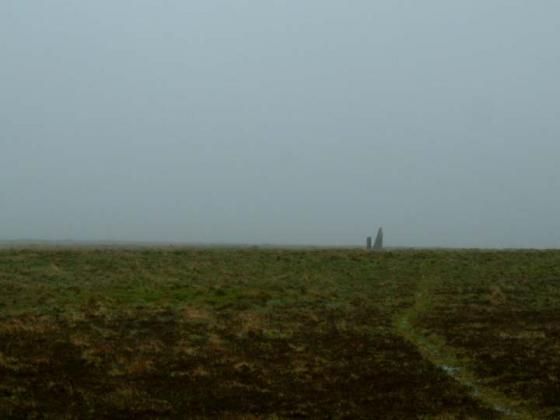
Elevated view of the meandering row, from its northern terminus (bottom right) towards the southern terminal cairn circle (over the brow of the hill, top left).

The row from its northern terminus.
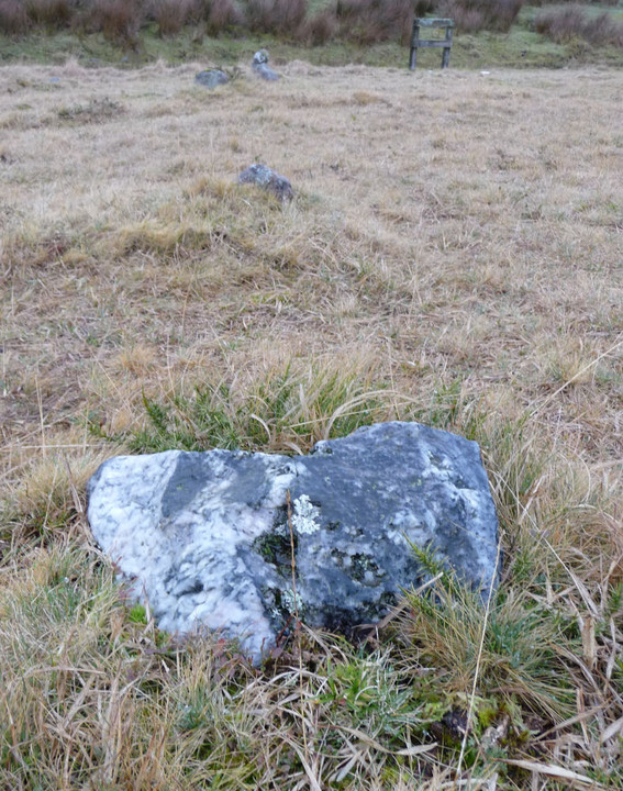
Nice quartz-veined stone towards the northern (lower) end of the row. This is one of the largest stones in the row.

Remains of kerbed cairn lying just to the east of the row, about halfway along its length and slightly uphill.

The southern end of the row, looking towards the terminal cairn circle (beyond the star post). Even in winter, the small stones are almost submerged into the turf.

Looking SW across the cairn circle (note tiny upright in the foreground). Larger stones of a ruined hut circle can be seen in the top left of the picture.

The southern arc of the terminal cairn circle (three stones visible), looking SE.

Looking NE across the cairn circle. Three of the remaining stones in the southern arc can be seen in the foreground.

This large slab lies along the northern perimeter of the terminal cairn circle. Otherwise, only very small stones remain, one of which can be seen immediately beyond the slab. The row runs north from the metal pole in the background.

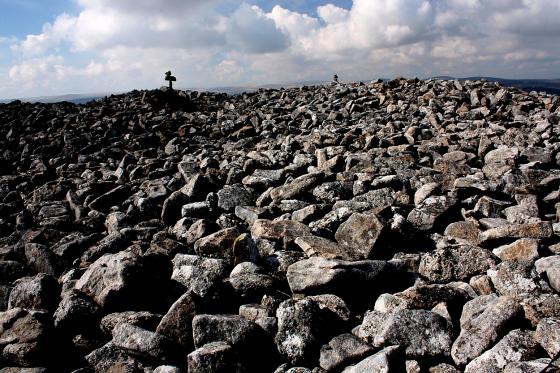
From atop of the waste tip you get a great view of the row running up the hill to the star post.

The end of the row...as far as we know. Did it ever continue under the waste tips?

Looking uphill (south) towards the star. The area around the row has been cut back, making it a lot easier to trace its route.

Looking north from the start of the row

The Northern Terminal of the Row

Short, but still part of a stone row.

West Saddlesborough – Stone Row – 25.6.2004 –Looking up the hill from the other end of the row (i.e. the northern end).

West Saddlesborough – Stone Row – 25.6.2004 –The star shaped marker near the start of the row (the southern end).

West Saddlesborough – Stone Row – 25.6.2004 –The start of the row, at the southern end.
March 20th 2009
At last, after being stuck inside during several days of sunshine I get a chance to leave the office and escape onto the moors. Having dropped my father at the hospital on the outskirts of Plymouth I ventured a short distance onto the south west edge of Dartmoor.
Saddlesborough seemed the easiest place to access and having parked the car at the little junction where the lane from Shaugh Prior meets the road going to Cadover Bridge I walked the short distance to the cross beside the road.
Crossing the road here it is not long before you reach a tumuli, a grass covered mound of stones with one large stone sitting just off the mound.
A quick photo and then I headed uphill to where I could already make out the star topped post. Between tumuli and post I thought I might have discovered a circle of stones, all recumbent but creating at least three quarters of a circle about 18 meters across..
As Pure Joy has said before, there are so many stones, it is easy for the mind to imagine things...
The Stone Row when I reached it had recently been cleared of any long grass or gorse and so my walk along it was easily traced. Plunging downhill it ends just before the waste tip of the nearby china clay pit. There is no evidence to suggest it ever went further, but one does wonder.
From the bottom of the row I headed east to discover the hut circles and enclosures lying along the north facing slope of the hill.
July 2003
This was a difficult one to find. The area is rich in hut circles, cairns and naturally occuring boulders. After an hour or so of wandering about and taking endless photographs of likely looking “alingnments”, I spotted the real thing. The stone close to the warning sign for the quarry marks the northern, lower terminal. In general though the stones were barely visible above the summer grass and were consequently difficult to capture on film. There IS a row here though, running N-S. Burl (Caranc to Calanish, p 237) claims that it’s 179 metres long.
West Saddlesborough – Stone Row & Cairn Circle – 25.6.2004
I knew nothing about this site except for what I could see on the map, which showed a litter of boundary work and hut circles, plus a cairn circle and a stone row, running for about 175 metres from SX554634 to SX555636
No obvious places to park. Best I could do was to find a suitable snippet of land off the road (which runs from Cadover Bridge towards Wotter). The whole area east of the road is Access Land. Probably the simplest place to start and to get your bearings is from the road side cross and footpath (marked with a tiny ankle height marker) circa SX552634.
The area is a litter of old field boundaries and hut circles, with bracken added in for fun (however, some of it has been recently cut away from around any archaeological features). I think I found the cairn circle and stone row. About 50 metres from the start point you should notice a cairn. Another 75 metres on from this (towards Saddlesborough summit) you should start to spot a low ditch and bank of some old boundary work accompanied by the first of several hut circles in the area. The map suggested the Cairn Circle is just to the north of this. I traced some stones in a circle in this area but it as definitely one of the days when you wonder whether you are seeing stone circles because you are looking for them or because you really are in the right place? All stones were tiny except for one massive stone! By the by, as you get slightly higher there are suddenly great views south, over Plymouth and out to sea.
However the good news is that there is what seems to be a long row of stones leading away from this area, down the hill. And an easy way to spot it is to look for one of the star shaped markers in his area (see pics above). I walked the line and counted 53 stones. The row seems to curve at the end as the slope gets steeper. The row ends about seven metres from a small gulley and a sign that marks the boundary with the Shaugh Lake part of the china clay works.