Eastern kerb cairn.
Image credit: A. Brookes (17.6.2022)
Eastern kerb cairn.

The central slab in the eastern kerb cairn, with the hilariously inappropriate label “Iron Age Field System” now affixed to it.

The eastern cairn. Impressive kerbs in the foreground, exposed chamber stone behind to the left. The Coast Path cuts right through.

The central barrow. Since we were last here, a sign has been attached, reading “Bronze Age Cairn”.

The central barrow, incorporating boulder.

Looking across the exposed top of the western barrow towards Armed Knight and Land’s End. Longships is barely visible top left.

The western barrow.

The coast path runs right through the kerb cairn, causing terrible damage to the mound.

Kerb slabs in the foreground, ruined cairn beyond.

The centre of the kerb cairn, with what might be the remains of a central chamber or cist.

The eastern of the three barrows we found, with remains of slab kerb. Carn les Boel cliff fort can be seen on the horizon, far right.

The central barrow.

The central barrow, with two boulders on the edges of the mound.

The central of the three barrows we found (adjacent to the western one).

The western of the barrows we found.

Stonework on top of the western barrow.

The western barrow, looking towards Longships and Armed Knight, with Land’s End over on the far right.

The western of the three barrows we found.
24 June 2014.
Midsummer has come and gone, but the perfect weather shows no sign of abating. After a longish coast walk and a lengthy delay on a broken down bus on the Lizard yesterday, we decide that the best thing to do is to laugh in the face of the Gods of Fate. So we take another bus, this time to Land’s End, for another coast walk.
Land’s End is generally a bit grim, as well as being endlessly thronged with tourists. But it has an interesting retired lifeboat to have a look at, as well as some truly breathtaking clifftop scenery, looking across towards the Longships and their lighthouse. Similar to the top of Snowdon, if you can apply your perception filter properly, the surroundings are still well worth the visit.
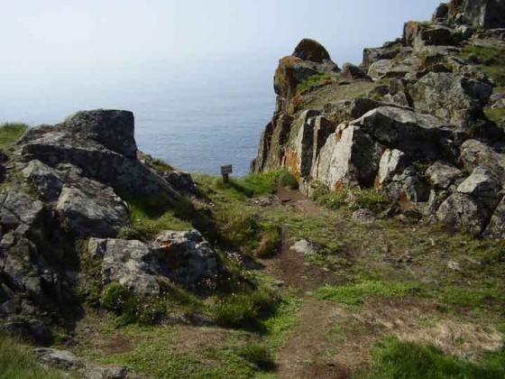
We make our excuses and leave the theme park environs as soon as we can, but the path is pretty busy round here on such a lovely day.We haven’t walked along this stretch of coast path for a long time, a dozen years maybe. And I’d forgotten just how lovely the granite cliffs at this extremity of the British mainland are.
I’m keen to revisit this section as I have only a very hazy recollection of the barrows my map assures me are here, and I’m also pretty sure we didn’t even visit Carn les Boel cliff fort when we were last here. Tut.
The crowds thin a bit as we reach Pordenack Point, a striking granite edifice of sheer cliffs and precarious looking boulders. Although we do have to contend with one inane couple who appear to have come here simply to phone their family to tell them what a lovely quiet spot this is. Loudly. Sigh.
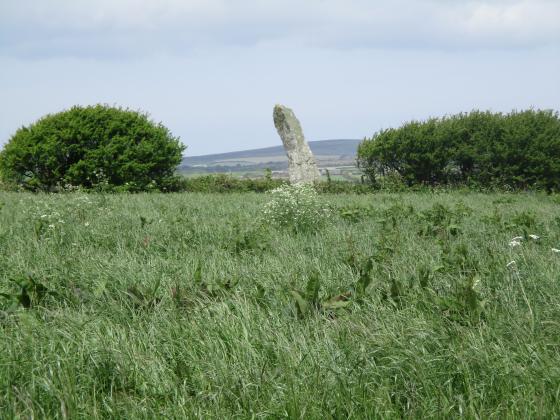
The barrows are a bit of a confusing site, badly eroded by being right on the coast path. The map says “tumuli” so I can be confident that there’s more than one anyway! Approaching from the northeast, the first promising mound has a central depression and some hefty stones around the edges. This is pretty much definitely a barrow or cairn, albeit a bit of a wreck.
Immediately next to this mound is a large boulder, and right next to that is another mound. This one also looks pretty barrow-ish, although apart from the mound itself, sandwiched between two boulders, there’s little in the way of anything structural to assist identification.
[Pastscape suggests three or four mounds/barrows here, but we only found three.]
The cliffs drop away dizzyingly to the southwest, to something the map calls Lion’s Den, while the coast path carries on southeast towards Trevilley Cliff. Before it drops to Zawn Trevilley we come across what would have been the finest of the barrows up here. Except that the coast path runs right through it and has gutted the site. This seems like such an idiotic and avoidable thing, but there we are.
What we are left with is still worth coming to though, a largely intact kerb of large slabs (it reminds me of the kerbed cairn south of Nine Maidens of Boskednan rather). There is also at least one sizable stone that appears to have formed part of a central cist or chamber, now eroded away. The setting is fabulous too, far-reaching views and dramatic rugged scenery, windswept and punctuated by gull cries. Yep, pretty good place to be laid to rest.
From here we head on round Nanjizel Bay on our way to visit the strangely neglected Carn les Boel.
Three or possibly four barrows on the rocky headland of Pordenack Point. The most easterly appears to have the remains of a retaining kerb or circle. Descriptions from Pastscape:
SW 34622417 (Russell No 8)
A mutilated or gutted turf-covered mound approximately 6.5m in diameter and about 0.7m high. Its centre is hollow and a few squarish boulders and stones are evident (almost at ground level) forming a crude structure which is approximately 2.0m by 1.2m internally and about 0.3m high. Spoil from the centre has been piled up on the sides thus heightening parts of the mound. The structure is almost certainly not the remins of a lookout hut as suggested by Geary because, again, all vistas, except to the north-west, are blocked by outcropping rock. It has the appearance of a crudely excavated mound with perhaps, as suggested by Russell, the remains of a cist in the centre. If this is the case it is odd that Henderson did not note the fact and also the existence of the adjacent mound in 1917 (c.f. SW 32 SW 5).
SW 34632417 (Russell No 9)
An amorphous earth and stone mound built on natural outcropping rock with three large contiguous retaining slabs on the east side. It is approximately 6.7m by 6.3m and up to 1.0m high. The largest of the three slabs is 1.1m high and has two drill holes in its outer face. It is probably a barrow but it may also be associated with the adjacent buried OS triangulation point.
SW 34632418 (Russell No 7)
An extensively mutilated turf-covered mound approximately 6.0m in diameter and up to 0.6m high; two large boulders protrude through the turf. There is no evident trace of a kerb and if it is a barrow it is in a very poor
condition.
SW 3468 2417
The mutilated barrow occupies a prominent cliff-top position on a heather-covered headland.
The remains of the incomplete kerb circle which measures approximately 11.0m in overall diameter comprises a total of nine exposed slabs and boulders. The largest standing slab is 0.9m high and 1.8m wide; the surviving part of the disturbed turf-covered mound averages 0.9m high.
The grave and possible small cist are as described although only the tips of the slabs protrude through the turf.
The south-west side of the mound has been completely eroded away by the coastal footpath which has cut through the kerb. The end stone of grave is now almost completely exposed and further damage will occur if the mound is not consolidated and the parth re-routed.
Published 1:2500 survey amended.
It is suggested that this barrow be scheduled.
Sadly the suggestion that the path be re-routed and barrow scheduled has not been taken up.