Images

Image of Butterdon stone row by thesweetcheat

Hobajons Cross, a (lightly) christianised stone that may once have been the northern terminus of the row, which now continues further north to the Longstone on Piles Hill. The skyline is covered with bronze age cairns – on the extreme left is Ugborough Beacon, in the centre are the three Butterdon Hill cairns, to the right is Western Beacon.

Image credit: A. Brookes (10.6.2010)
Image of Butterdon stone row by thesweetcheat

Looking north towards Sharp Tor and Three Barrows. This stone, although on the line of the row, is a modern (19th c) insertion – it is much taller than the other stones in the row, which are graded. As the row would be difficult to trace in bad conditions, taller stones like this would have been added to clarify the position of the parish boundary, which follows the line of the row.

Image credit: A. Brookes (10.6.2010)
Image of Butterdon stone row by thesweetcheat

Looking back southwards along the row towards the prominent Butterdon Hill summit cairns.

Image credit: A. Brookes (10.6.2010)
Image of Butterdon stone row by thesweetcheat

Folllowing the row north as it approaches Butterdon Hill (north) cairn – on the right.

Image credit: A. Brookes (10.6.2010)
Image of Butterdon stone row by thesweetcheat

Diminuitive stones at the south end of the row, with Butterdon Hill summit cairn behind. This southern end of the row is just to the west of the cairn circle.

Image credit: A. Brookes (10.6.2010)
Image of Butterdon stone row by Meic

Butterdon Hill stone row 23rd June 2003.

Image credit: Michael Mitchell
Image of Butterdon stone row by Lubin

A photo of the “Longstone” on the southern slopes of Butterdon Hill. This stone is part of a row of boundary stones another can be seen on the top of the hill.

Image credit: Peter Castle ©
Image of Butterdon stone row by Lubin

A photo of the stone marked on the O.S. map as the Longstone.

Image credit: Peter Castle ©
Image of Butterdon stone row by Lubin

The stone marked on the O.S. map as the Longstone at SX655583. This is marked as a boundary stone and is in the line of stones put up between 1800 and 1803 to mark the boundary of Ugborough and Harford, but looks a lot older than the other stones in the row.

Image credit: Peter Castle ©
Image of Butterdon stone row by Mr Hamhead

Well hidden cairn to the north of the Butterdon Hill barrow. The stone row runs from here northwards. Its route is now marked by the well worn pathway. In the distance the central hill is Three Barrows, one of which can just about be picked out on the top.

Image of Butterdon stone row by Lubin

The Longstone on Piles Hill, at SX654608, is thought to be the last stone of the row and stands just over two metres high. One of the boundary stones can be clearly seen beside it.

Image credit: Peter Castle ©
Image of Butterdon stone row by Lubin

Hobajon’s Cross, one of the stones in the Butterdon Row, that stands on Piles Hill, has been Christianised by adding a cross. This stone is towards the northern end of the row at SX655605.

Image credit: Peter Castle ©
Image of Butterdon stone row by Lubin

The Butterdon Row looking south from Hobajon’s Cross. The cairn can be seen on the hill in the distance. Some of the stones in this row have been added as boundary stones at a later date. These are quite obvious as they are perfectly shaped.

Image credit: Peter Castle ©

Articles

Butterdon stone row

Anyway, I have found my first Dartmoor cairn circle and from here I can find the start of my first row. It heads roughly north, consisting of small (a foot or so tall) stones and crosses over a mile of moorland to a terminus on Piles Hill. On its route it passes the sandcastle-esque Butterdon Hill (north) cairn, which has gained its unusual look by excavation followed by a covering of turf. The direction of the row changes slightly north of this cairn, possibly suggesting that it was erected in more than one phase.

As the row starts to head up towards Piles Hill a taller and more modern boundary marker creeps in amongst the lower stones of the row. Further north Sharp Tor and Three Barrows are now in view, more hills topped with bronze age cairns. As the row approaches Hobajons Cross it still consists of very low stones, and the cross itself is merely a taller upright that has been christianised by the incision of a small cross near its top. It is possible that this stone was once the terminus of the row (see Jeremy Butler’s “Dartmoor Atlas of Antiquities”). From here most of the stones are missing as the line of the row climbs Piles Hill to its leaning terminal stone (shown as “recumbent” on the OS).

Miscellaneous

Butterdon stone row
Stone Row / Alignment

Information about the row from Pastscape, including the possibility that it terminated at Hobajons Cross, rather than the Longstone on Piles Hill.

“( SX 65635880 – SX 65526037) Stone Row (NR) (1)

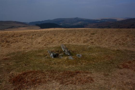
A stone row extending from a barrow on Butterdon Hill (SX 65 NE 66) to Hobajons Cross (SX 66 SE 58 a standing stone at SX
65516047). The row formerly extended north from Hobajons Cross to the Longstone (a standing stone at SX 65436074) on Piles Hill,
but this stretch was destroyed in 1803 (see SX 66 SE 107).

Also in 1803 stones split by the tare and feather method were introduced into the row, when the alignment was accepted as the boundary between Harford and Langford Lester Moors.(2)(3)

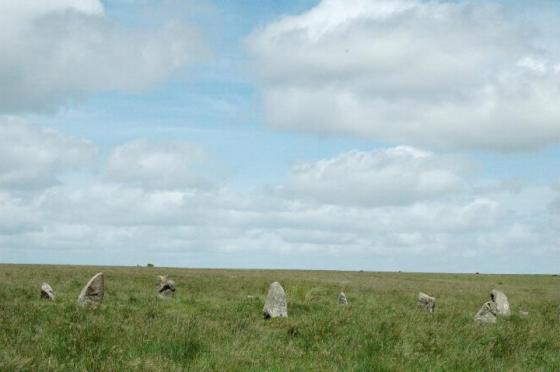
The northern part of the Butterdon stone row has been surveyed from Hangershell Rocks cairn at SX 65645941 to Hobajons Cross
at SX 65506045.

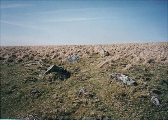
For the 1050m of this part the majority of the several hundred stones are from 0.1m to 0.4m high and form an irregular line. There is a gap of 70.0m on the north side of Hangershell but otherwise the row is fairly continuous. The area is not entirely free of natural surface stones and while some can be immediately discounted occasionally there is a short double or triple row
where all the stones are alike and these which formed the original row cannot now be determined. Barely two dozen stones
are 0.5m high or higher, Hobajons Cross at 1.2m being the highest. It is possible that this was at some stage a terminal stone since it appears to have cup marks on the south face and the extension onwards, to the Longstone, is on an entirely different alignment.”

hhttps://www.pastscape.org.uk/hob.aspx?hob_id=441148

Miscellaneous

Butterdon stone row
Stone Row / Alignment

A glance at the map will show you so many stone rows in this area – but the one I mean here is the longest at 1900 metres! It runs north-south along the top of this ridge of moor. Burl quotes it being referred to in a Saxon charter as “the old way with the white stones”, and suggests that there must have been over 2000 stones at one time. Blimey.

Sites within 20km of Butterdon stone row