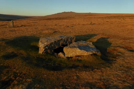
The long stone and Kestor rock.
Image credit: Chris Bickerton
The long stone and Kestor rock.

DC, I’d put a million pounds on that being the same DC as was at White moors outlier.
Any guesses for what DC stands for, I think I know.

It’s that stone, you know, the Long one.

Some northern joker has slipped in a four poster.

Shovel down stone circle (2 stones left) is over the brown of the near hill, left. Just over the left most trees is Scorhill stone circle, honestly, Dartmoor eh?

As you can see the tallest stones in the row rise upto the circle, Downtor like.

I think these two long stones are rising upto the stone circle Downtor like, if you know what I mean.


Approaching Kestor rock from the Shovel down stone row, another example of stones and outcrop as one.

The Tadpole filled rock basin on Kestor rock overlooks Shovel down.

Kestor rock from the west

13 March 2011 CE

13 March 2011 CE

13 March 2011 CE

13 March 2011 CE

the concentric stone circles at the end of one of the rows – what was it for?

The Longstone – 4th March 2006

The Longstone

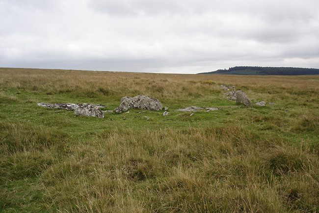
Shovel Down circle – 28th December 2004

Shovel Down circle – 28th December 2004

28th December 2004

4th March 2006

Three Boys stone 2003

Three Boys 28th February 2005

Three Boys 28th February 2005
Part of the settlement wall that is uphill to the southwest of the rows.

Part of the settlememt wall that is up hill to the southwest of the rows.

One of the reaves running northeast from Stonetor Brook to Batworthy corner.

Looking downhill from the cairn, towards the Batworthy corner.

The cairn at the top of the hill leading to the Longstone .

The row that leads away from the right of the fourfold circle to the cairn on the top of the hill. Looking south.

The fourfold cairn circle with Kes Tor in the background.

The last two stones of the row with the four fold cairn circle at its other end. These stones are not far from Batworthy corner.

The last remaining stone of the “Three Boys”. This stone is around 200 metres south of the Longstone.

The Longstone with the stones nearest to it.

The two stones that remain standing on the northwest arc.

The Shovel Down Circle looking northwest, showing all three remaining standing stones.

The Longstone, looking northeast, with Kes Tor in the background.

The fallen stones next to the fourfold circle at the end of one of the double rows. This stone has been cut with G P to mark the boundary of Gidleigh and Chagford. The G P standing for Gidleigh Parish.


Shovel Down Complex – 1.4.2004. Last part of the north west row.

Shovel Down Complex – 1.4.2004. The last survivor of the Three Boys? Mainly fallen.

Shovel Down Complex – 1.4.2004. The Long Stone on a misty day.

Shovel Down Complex – 1.4.2004. The small concentric stone circles, trying to show the three concentric rings of stones. Massive stones and the north east stone row behind it.

Shovel Down Complex – 1.4.2004. The view you get as you enter the complex from the south. This is the bottom end of the north east row, looking up it.

General view looking N with three of the five rows visible. The one to the right adjoins the Fourfold circle. Another row is located just off picture to the right and the fifth (which runs to the Longstone) starts S of this point. Scorhill is in the distance just beyond the trees.

Fourfold circle and adjoining row. Fourfold circle has four concentric rings of stone almost circular – outermost is 9m diameter.

Distant view of Longstone (3.1m) with remains of adjoining row.

The main row (to the left of this one) goes for ‘miles’ & even when it seems to peter out, you can often find the stones under the turf.... It is traceable just about all the way to those woods & curves left if memory serves, to head towards Scorhill stone circle which is on the moorside beyond!
There’re also lots of rocks & erratics with a few possible cairny-type bits by the woods.

As with most pics of the longstone, the boundary-marker ‘grafitti’ is extremely evident....


8th September 2001

8th September 2001

8th September 2001

8th September 2001

The fiftysomethings never even ventured over the brow of the hill to visit the Longstone – missed out.

We arrived at the same time as a herd of fiftysomethings on a tour. so we sat around until they cleared off.
Interesting to think what the Y avenues were for. A convergence of paths for marraige perhaps?

The rows here seem to meander forever taking the traveller past the almighty great nearby tor and point you towards the stone circle 1km at Scorhill. The longest stone row idles its way across the moor with two lines of small stones, some hidden under grassy hummocks. Walking the length is not an option. You have no choice but to do it. The most complete section is actually not part of the main row, but deviates off pointing back down to Batworthy.
Shovel Down Complex – 1.4.2004
The instructions on the megalithic walks website (see link below) are excellent. Just a couple of additions though. First, to be clear that the bridge mentioned (i.e. where to park) is just outside Batworthy Farm, at SX662866. The space near the bridge should take 4 to 5 cars. I also saw cars parked at various small places off the road over the common, but the bridge area is better and more sensible. Secondly, the journey through the lanes is pretty tortuous, but at least you shouldn’t get lost if you have an OS map. Once successfully on the right road (after the crucial junction at SX690870), it is pretty much follow the road and don’t take any of the turnings off the lane. To avoid some of the earlier lanes try the B3206 to Chagford from the A382. Be careful to avoid the Range Rovers though! Judging from the cars and the shops this ancient Stannary town looks like a squeaky clean Devon version of Hampstead!
As you walk up towards Batworthy Corner, the north east most row comes clearly into view. A few hundred metres on and you’ve experienced your first bit of Shovel Down! This first row leads to an intriguing circle of three concentric stone circles. Up and over the hill and the enormous long stone suddenly comes into view. This massive, enigmatic stone has lots of stones around its base. Are they modern? They somehow don’t look quite right. The southern stone row (as shown on the OS map) basically doesn’t exist; there is nothing there.
I believe I found the remaining one of the ‘Three Boys’, but it is 70% fallen. From here, if you know where you are looking you can just see the top of the Long Stone. It would be interesting to know if it could be seen from the top of the three boys when it was / they were erect.
There must be 3 rows to the north, not just two as the OS map shows. The middle row starts and continues further away from the others, and is a good way to walk onwards to Scorhill.
When I later returned to the bridge I was led down the rocky path by a dog from Batworthy Farm, like Lassie leading an injured child!
The beeting of the bounds around the parishes where this stone is the meeting point of used to be an occasion for fighting, and of moving the boundry stones (presumably not this one as it is huge!)
Mildren, James 1984 Dartmoor in the Old Days Cornwall, UK : Bossing Books
Grinsell records that during the annual beating of the bounds of Gidleigh common, the first man to reach the long stone was given money as a prize.
(’folklore of prehistoric sites in Britain’)
The longstone is said to move round slowly at sunrise so that each face is warmed by the sun in turn. A similar story exists for the stones of the GreyWethers stone circle.
Details of the remaining Three Boys stone on Pastscape
(SX 66038549) Three Boys (Cromlech) (NR) (Remains of). (1)
The stone marking the southern end of a stone row (’F’ SX 68 NE 16) is the only survivor of three such stones known as the Three Boys. It stands 4 1/2 feet high and leans over. The other two have been removed to form gateposts for a neighbouring enclosure. The suggestion that they formed the supporters of a dolmen is unlikely as the remaining stone would be quite unsuitable for this purpose. They were probably three unusually large stones used to mark the end of the stone row. (2)
(SX 66038549) Three Boys (NAT) Standing Stone (NR). (3) The remaining stone of Three Boys leans at 45o to the NNE; it is 1.7m long, 0.8m wide and 0.3m thick. Packing stones are visible at its base. A surrounding wet-hollow, diameter 3.7m, depth 0.4m,has been created by sheep. There is no trace of a mound. The situation, shape and size of the stone strongly suggests that it formed a terminal/blocking-stone to the double stone row (SX 68 NE/16 ‘F’) which originally extended from the Three Boys to Long Stone. Published 1:2500 survey revised. (4) As described by authority 4. Se Sx 68 NE 16 E-F. (see also RCHME survey `The Shovel Down Stone Rows’(part 1) at 1:200 scale). (5)
Burl (in his book on stone rows) describes a stone further south than the Longstone, at SX660855 – the surviving stone of the ‘Three Boys’ , the other two apparently taken away for gateposts. The remaining boy is about 4 1/2 ft high.
Where else can you find a Stone circle a stone row and a standing stone in the same location?