Looks like a ring cairn to me, it lies at the main junction of footpaths on the hill. See the stone left of centre, there’s a smaller ringish cairn just behind it.
Image credit: Chris Bickerton
Looks like a ring cairn to me, it lies at the main junction of footpaths on the hill. See the stone left of centre, there’s a smaller ringish cairn just behind it.

The north end of the ring cairn, with a little bump off to one side, another little ring cairn?

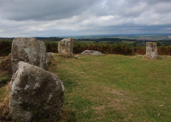
This large kerb cairn lies just a few yards south of the stone circle.

This large kerb cairn lies just a few yards south of the stone circle.

This large kerb cairn lies just a few yards south of the stone circle.

This large kerbed cairn lies just a few yards south of the stone circle.

This little cairn is close to the cairn circle, about fifty yards WSW. ( It could also just be a mortar pit dug by practicing squadies prior to WW2)

This cairn and a smaller less visible cairn lie just a few yards north of the stone circle.

This slightly disheveled cairn is about half way between the Giants grave and the ring cairn.
( It is actually a mortar pit dug by practicing squadies prior to WW2)

This slightly disheveled cairn is about half way between the Giants grave and the ring cairn.
There are loads of cairns up here, some are more cairnish than others, the ring cairn type one the big stoned kerb cairn, the grassy bump type and the stone rubble with a pit in type. But, the latter is not a cairn, there is one on the circumference of the stone circle, that’s not a cairn, there is one by the Giants grave, that’s not a cairn either. They are both in fact mortar pits dug by practicing soldiers waiting for D day in WW2. Perhaps a more poignant type of monument than most cairns, or perhaps not.
Mardon Down Cairns – 3.4.2004
For directions to the general area, see the record for Mardon Down.
There are 4 cairns marked on the OS map. Two are apparently where the track kinks to the right half way between the stone circle and the cairn circle (SX767874). And two are supposed to be very close to the stone circle, one shown on the map as maybe 50 metres south of the stone circle, and one immediately north of the stone circle. Hmmm, well I didn’t look for the northern two because I wanted to see the cairn circle and then go.
But I did find what I thought was a kerbed cairn just a few metres south of the stone circle. However that doesn’t tally with the map. Curious.
Mardon Down – 3.4.2004
I approached via Moretonhampstead but in the jumble of roads and junctions in the middle of the small town I couldn’t honestly give good directions to find the lane that leads up to the downs! I can say that it isn’t signposted at all and it might have been ‘School Lane’(?). I just felt the lane was the right one judging from the OS map. If you then go down and back up a dip, and pass Addiscott on your right you are on the right lane! I left the downs due south, onto the B3212 (which by the way is a really twisty and narrow B road for much of its length), which was really easy so this might be a better way.
This is all Access Land, so you can roam at will. There is a sort of ‘car park’ at SX762873. If you are coming onto the common from the south west, take the road to the right (marked ‘Exeter’) and it’s 200m up the road on the left. However, all it is is the only tarmaced area on the common. No facilities. In fact when I was there most of it was taken up with mounds of gravel. In reality people park all over the downs as most of the roads have clear spaces off of them at intervals (and they aren’t passing places).
There are loads of paths all over the downs. All seem pretty basic and liable to mud. Some might get overgrown in summer. Gorse almost everywhere. The car park is a relatively convenient place to park as there is a clear path up to the top. However this is a bit more of a climb (55m in height in a 500m walk) than from the south end.
The track that is marked on the OS map that goes across the top of the hill doesn’t really live up to it’s billing and exists only in places as a track wide enough for a 4x4. Some of the time it’s just like a footpath, and can be boggy. But it is a convenient way to help find the ancient sties on this hill.
At 356 metres above sea level there are not surprisingly brilliant views from the hill.