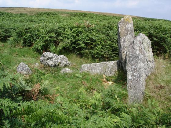
Log in
|
Register
Home
Latest Posts
Forums
Maps
Help
Browse Sites
News
Blog
Contributors
The Books
Select
-
Belgium
Denmark
Eire
France
Greece
Italy
The Netherlands
Norway
Portugal
Republic of Malta
Spain
Sweden
Switzerland
United Kingdom
England
Southern England
Devon
Dartmoor
Dendles Waste
Cist
Dendles Waste (Cist) on The Modern Antiquarian, the UK & Ireland's most popular megalithic community website. 1 image, 1 fieldnote, plus information on many more ancient sites nearby and across the UK & Ireland.
Image © Peter Castle ©
Nearest Town:
Plympton (9km SW)
OS Ref (GB):
SX615627 /
Sheet: 202
Latitude:
50° 26' 49.71" N
Longitude:
3° 57' 3.45" W
Added by
Lubin
Images (1)
Fieldnotes (1)
0 discussions
Start a topic
Show |
Hide
Web searches for Dendles Waste
Flash Earth
Flickr
Google
Google Images
MAGIC
The Megalithic Portal
Multimap 1:25000
Stone Pages
Streetmap.co.uk
Wikipedia
Show map
(inline Google Map)
- Sites within 20 km -
-
Coombebrook North East (0.9km E) (2 posts)
Harrowthorn Plantation North (1.03km E) (2 posts)
Ranny Brook (1.03km NNE) (4 posts)
Stalldown Cairns (1.36km E) (7 posts)
Penn Beacon (1.61km W) (2 posts)
Penn Beacon South (1.61km WSW) (3 posts)
Stall Moor (1.72km NE) (1 post)
Stalldown cairn circle (1.72km E) (3 posts)
Stalldown Stone Row (1.74km E) (47 posts)
Shell Top (2.1km W) (3 posts)
Hillson's House (2.33km E) (8 posts)
Blatchford Bottom settlements (2.55km ENE) (3 posts)
Stall Moor Stone Circle (2.62km NE) (20 posts)
Blatchford Bottom 2 (2.63km NE) (2 posts)
Stalldown South-East (2.66km E) (10 posts)
Stall Moor Cairn (2.97km NE) (7 posts)
Tory Brookhead (3km W) (0 posts)
Cholwich Town (destroyed) (3.02km WSW) (2 posts)
Tory Brookhead (3.05km W) (7 posts)
Shell Top South West (3.39km W) (0 posts)
Burford Down (3.4km ESE) (14 posts)
Burford Down cairn and cist (3.41km ESE) (4 posts)
Spanish Lake (3.44km W) (1 post)
Hook Lake (3.46km NE) (4 posts)
Hook Lake (3.54km NE) (5 posts)
Sharp Tor (3.6km E) (7 posts)
Willings Walls Reave (3.61km W) (2 posts)
Grim's Grave (3.71km NNW) (5 posts)
Erme Pound (3.71km NE) (5 posts)
Hen Tor North / Shavercombe Brook (3.77km WNW) (8 posts)
Three Barrows (3.79km E) (10 posts)
Harford Moor (3.9km ESE) (10 posts)
Trowlesworthy Warren (4km W) (6 posts)
Trowlesworthy Stone Row East (4.07km W) (10 posts)
Brown Heath (4.13km NNE) (0 posts)
Willings Walls Warren (4.13km WNW) (2 posts)
Langcombe Brook / Deadman's Bottom (4.17km NNW) (13 posts)
Trowlesworthy (4.19km W) (0 posts)
Little Trowlesworthy Tor (4.19km W) (2 posts)
Piles Hill (4.19km E) (9 posts)
Trowlesworthy Stone Row West (4.19km W) (9 posts)
Piles Hill (4.37km E) (10 posts)
Ditsworthy Cairn Circle (4.38km WNW) (2 posts)
Butter Brook Ford (4.61km ESE) (6 posts)
Western White Barrow (4.65km NE) (4 posts)
Emmets Post (4.71km W) (1 post)
Willings Wall Warren (4.74km WNW) (3 posts)
Glasscombe Ball (4.77km E) (5 posts)
Glasscombe Ball North (4.8km E) (1 post)
Butterdon (4.81km E) (25 posts)
Trowlesworthy Warren (4.82km W) (2 posts)
Calveslake Tor (4.85km NNW) (3 posts)
Legis Tor Cist (4.95km W) (6 posts)
Drizzlecombe Megalithic Complex (4.96km NW) (94 posts)
Glasscombe Corner (4.96km E) (13 posts)
Weatherdon Hill (5.15km ESE) (3 posts)
Spurrell's Cross Stone Row (5.17km E) (8 posts)
Corringdon Ball Stone Row (5.17km E) (16 posts)
Great Gnat's Head (5.2km NNW) (4 posts)
Butterdon Hill (north) cairn (5.3km ESE) (4 posts)
Corringdon Ball (5.3km E) (1 post)
Whittenknowles Rocks Settlement (5.32km WNW) (5 posts)
Glaze Meet (5.35km E) (4 posts)
Gutter Tor (5.51km WNW) (3 posts)
Stall Moor Stone Row (5.51km NNE) (15 posts)
Eastern White Barrow. (5.53km ENE) (1 post)
Corringdon Ball Long Barrow (5.54km E) (12 posts)
Addicombe (5.55km ESE) (0 posts)
Gutter Tor (5.59km WNW) (2 posts)
Butterdon Hill (5.64km ESE) (20 posts)
Gutter Tor Cist (5.65km WNW) (4 posts)
Butterdon Hill cairn circle (5.66km ESE) (6 posts)
Saddlesborough (5.7km W) (0 posts)
Brisworthy Stone Circle (5.71km W) (44 posts)
Butterdon Hill (5.72km ESE) (0 posts)
Ringmoor Down Cist (5.81km W) (4 posts)
Eylesbarrow South West (5.86km NW) (2 posts)
Huntingdon Warren Settlement (5.99km NE) (2 posts)
Ringmoor Down (6.06km WNW) (3 posts)
Ringmoor Down (6.06km WNW) (1 post)
Gutter Tor (6.07km WNW) (1 post)
Shaugh Moor (6.08km W) (3 posts)
Ringmoor Cairn Circle and Stone Row (6.09km W) (43 posts)
Eylesbarrow (6.11km NW) (8 posts)
Biller's Pound (6.11km NE) (3 posts)
West Saddlesborough Hut Circles (6.12km W) (3 posts)
West Saddlesborough Stone Row & Cairn Circle (6.12km W) (11 posts)
Butterdon Hill Chambered Tomb (6.14km ESE) (7 posts)
West Saddlesborough Cairn (6.22km W) (3 posts)
Yellowmead SE cairn (6.26km WNW) (5 posts)
Heap of Sinners (6.29km NE) (4 posts)
Ringmoor Kerbed Cairn (6.31km W) (5 posts)
Cuckoo Ball (6.35km ESE) (12 posts)
Snowdon (6.39km NE) (7 posts)
Yellowmead Multiple Stone Circle (6.47km WNW) (49 posts)
Western Beacon (6.47km ESE) (21 posts)
Rider's Rings (6.48km ENE) (0 posts)
Outcombe (6.56km WNW) (2 posts)
Ringmoor Down Reave (6.6km W) (1 post)
Cuckoo Rock (6.7km NW) (3 posts)
Brockhill Foot West (6.74km ENE) (4 posts)
Aish Ridge (6.91km E) (4 posts)
Brockhill Ford West (6.91km ENE) (2 posts)
Cantrell Stone Row (6.99km ESE) (5 posts)
Round cairn east of Down Tor (7.12km NW) (4 posts)
Enclosure east of Down Tor (7.16km NW) (4 posts)
Wigford Down (7.25km W) (8 posts)
Down Tor (7.25km NW) (39 posts)
St Leonard's Well (7.27km WNW) (4 posts)
Pupers Hill (7.31km NE) (4 posts)
Down Tor South (7.37km NW) (3 posts)
Goldsmith's Cross/Fox Tor Mire (7.5km N) (5 posts)
Hingston Hill North (7.5km NW) (3 posts)
Shell Top South West (7.61km W) (9 posts)
Gripper's Hill (7.61km ENE) (3 posts)
Childe's Tomb (7.65km N) (7 posts)
Dewerstone Settlement (7.7km W) (8 posts)
Boringdon Camp (7.72km WSW) (12 posts)
Fox Tor Mire (7.73km NNW) (2 posts)
Harbourne Head (8.04km ENE) (3 posts)
Harbourne Head (8.39km ENE) (6 posts)
Ryder's Hill (8.43km NNE) (3 posts)
Ter Hill (8.49km N) (3 posts)
Leather Tor South (8.54km WNW) (2 posts)
Mardle Valley (8.68km NE) (2 posts)
Skir Hill (8.76km NNE) (1 post)
Raddick Hill (8.98km NW) (3 posts)
Royal Hill Cist (9.41km N) (4 posts)
Joan Ford's Newtake (9.53km N) (4 posts)
Leeden Tor South (9.56km WNW) (2 posts)
Hart Tor (9.69km NW) (7 posts)
Hart Tor North Stone Circle & Rows (9.76km NW) (3 posts)
Hart Tor (9.76km NW) (3 posts)
Black Tor (9.78km NW) (2 posts)
Sharpitor (9.78km WNW) (12 posts)
Royal Hill (9.79km NNW) (0 posts)
Sharpitor (9.81km WNW) (8 posts)
Holne Moor (9.81km NNE) (3 posts)
Black Tor (9.97km NW) (2 posts)
Down Ridge (10.28km NNE) (6 posts)
Horseyeatt (10.29km WNW) (5 posts)
Holne Moor Triple Row (10.31km NE) (2 posts)
Swincombe Ford Newtake (10.35km N) (2 posts)
The Crock of Gold Cist (10.39km NNW) (7 posts)
Sherberton Stone Circle (10.76km N) (12 posts)
Aller Brook (10.89km NE) (2 posts)
Ingra Tor (10.89km WNW) (2 posts)
Blakey Tor (11.09km NNW) (3 posts)
Yes Tor Bottom (11.17km NW) (2 posts)
Round Hill (11.7km NNW) (8 posts)
Yar Tor Hut Circle (12.2km NNE) (6 posts)
Coffin Stone (12.26km NNE) (1 post)
Dunnabridge Pound (12.29km N) (6 posts)
Hembury Castle (12.49km ENE) (4 posts)
Yellowmeade (12.79km NW) (3 posts)
The Plague Market At Merrivale (13.02km NW) (96 posts)
Laughter Tor (13.31km N) (11 posts)
Merrivale Stone Circle (13.4km NW) (24 posts)
Vixen Tor (13.68km WNW) (6 posts)
Yar Tor (13.85km NNE) (4 posts)
Merrivale Bridge Settlement (13.89km NW) (7 posts)
Corndon Tor (13.92km NNE) (1 post)
Long Plantation (13.99km NNW) (3 posts)
Bellever (14.11km N) (32 posts)
Barn Hill / Whitchurch Down (14.34km WNW) (3 posts)
Wistman's Wood (14.39km NNW) (3 posts)
Blackdown Rings (14.82km ESE) (2 posts)
Littaford Tor (14.99km NNW) (1 post)
Stennen Hill (15.12km N) (3 posts)
Lakehead Hill (15.26km N) (43 posts)
Great Western Reave (15.54km NW) (2 posts)
White Tor Stone Row (15.59km NNW) (2 posts)
Kraps Ring (15.66km N) (5 posts)
Crow Tor (15.92km NNW) (3 posts)
Rowtor Bog Cairns (15.93km N) (4 posts)
Langstone Moor (15.99km NNW) (1 post)
Archerton, Newtake (16.25km N) (3 posts)
Cator Common North Cairn (16.38km NNE) (4 posts)
Langstone Moor (16.41km NW) (2 posts)
Langstone Moor Stone Circle (16.53km NW) (9 posts)
Conies Down (16.64km NNW) (1 post)
Chittaford Down (16.82km N) (11 posts)
Chittaford Cairn and Cist (16.91km N) (5 posts)
Soussons Common Cairn Circle (16.98km NNE) (27 posts)
Beardown Man (16.99km NNW) (13 posts)
Roundy Park (17.15km N) (1 post)
Roundy Park (17.15km N) (11 posts)
White Tor East (17.31km NW) (2 posts)
Langstone Moor Stone Row (17.34km NW) (6 posts)
Blackslade Down (17.44km NE) (1 post)
Soussons Down (17.98km NNE) (2 posts)
Broad Down Cairn (18.09km NNW) (3 posts)
Rippon Tor (18.35km NE) (8 posts)
Stannon Newtake (18.69km N) (2 posts)
Ritson Barrows (19.12km E) (1 post)
Stanborough Camp (19.18km ESE) (1 post)
Water Hill (19.31km NNE) (1 post)
Mount Edgcumbe Barrow (19.33km WSW) (2 posts)
Halwell Camp (19.33km E) (1 post)
Water Hill (19.43km NNE) (1 post)
Challacombe (19.62km NNE) (19 posts)
Hamel Down (19.83km NNE) (6 posts)
- Facilities within 20 km -
-
The Plume of Feathers Inn (Pub: 11 km NNW)
Warren House Inn (Pub: 19.3 km N)
- Add -
-
Add news
Add an image
Add fieldnotes
Add folklore
Add miscellaneous
Add a link
-
Add a site
Add a nearby facility
Add an alternative name/spelling
Images
(click to view fullsize)
Add an image
Fieldnotes
Add fieldnotes
The cairn/kist is in a part of the Dendles Plantation that has been cut down so is easy to find.It is situated just to the side of the path which runs through the wood and has had a marker put nearby to show where the kist is.
Comments (0)
|
Add a comment
|
Permalink
Posted by
Lubin
20th April 2005ce