Looking ‘down’ [what I presume to be] the long cairn, highlighting the central trench.
Image credit: Robert Gladstone
Looking ‘down’ [what I presume to be] the long cairn, highlighting the central trench.

The much smaller attendant cairn.... I assume constructed from the larger by persons unknown in times unknown.

Do we have another long cairn here?

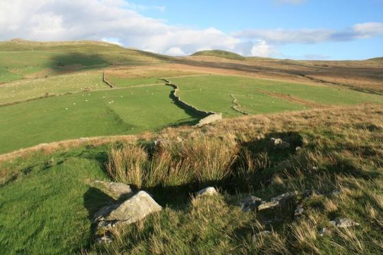
Crib Goch appears anything but ‘red’ to the right; Y Lliwedd rises to the left of image.

Looking down Dyffryn Mymbyr... the position of a further cairn (with cist) is indicated.

The raging outflow of Llyn Cwmffynnon provides a touch of relief to the brutal flanks of Y Glyderau. Believe it or not there is a stone circle beside the source...........

The Snowdon Massif rears up upon the skyline.
Marked upon the map simply as ‘cairn’, this is in fact a much more substantial monument than that basic categorisation would indicate. Hell yeah! Set above Pen-y-Gwryd, with its hotel (which incidentally acted as the training base for the first successful ascent of Everest), Llyn (Lockwood) and Roman camp (the usual thing), this monument appears to be much more of a long cairn than that above Nant-y-Llys approx half a mile to the south.
It is from the Nant-y-Llys cairn that I approach, my intrigued nature having got the better of me as I enjoyed the vibe there, buffetted by the fierce wind and frequent squalls. The Snowdon Massif is quite literally overpowering if the approach is made from this direction, the deep bogs worthy of Ireland, my new Gortex boots somehow passing the ultimate test. Passing to the right of a small, rocky hill, the size and exquisite siting of the cairn is suddenly all too apparent... and welcome. Dyffryn Mymbyr stretches away to the east, the two dry stone walls indicating the postion of the larger cairn-circle just visible before the Llynnau Mymbyr, Carnedd Moel Siabod rising majestically above to the right. To the approx north the raging outflow of Llyn Cwmffynnon leads the gaze up to the most brutal, austere mountains you could ever wish to see... Glyder Fach and Glyder Fach, the rock formations of Castell y Gwynt (literally ‘castle of the winds’) to this observer seemingly evoking every emotion the Welsh landscape and language can convey... all in one searingly evocative skyline profile. Which leaves Yr Wyddfa itself.... except it refuses an audience, leaving Y Lliwedd and Crib Goch to crown the western skyline alone. They deputise admirably for the moody one.
The site in fact consists of two stone piles, a much smaller sibling standing beside the much larger monument to the south-west, although in all probability two were once one, so to speak... judging by the trench which runs the length of the large cairn – I mean, where did those stones go to? Whatever the truth, the volume of cairn material remains relatively impressive, the monument by all accounts sited to overlook Dyffryn Mymbyr and – as with the nearby Nant-y-Llys – not focussed upon The Snowdon Massif. Hmm. Please, please tell me now. Is there something I should know? Probably. But it escapes me. Was Yr Wyddfa too important to be directly viewed?
This Bronze Age cairn is described by the experts thus:
Gwynedd Archaeological Trust (PRN1478):
‘Cairn, built of roughly piled stone 9m in diameter robbed at the centre to form a sheep shelter. Height 1m the kerb is nowhere pronounced but a few non orthostatic kerb stones are visible’....’ A well defined cairn of piled stone. Kerb not obvious but turfed over edges could hide this. Centre dug out to about surrounding ground level. Small cairn built to SW, not recent, but probably using stone from centre. Siting: on a wide north-facing terrace at the top of a steep slope from Nant Cynnyd – on the line of sight along the valley.‘
Sources :
Prehistoric Funerary and Ritual Monument Survey: West Gwynedd & Anglesey , SMITH, G. , 2003 , Caernarvonshire 2 , Royal Commission on Ancient and Historic Monuments , 1960 , SH65NE 5 , Ordnance Survey , 1970 ,