2 x marks the spots, on the left this long cairn and on the lower right Dyffryn Mymbyr stone circle, they aren’t inter visible.
Image credit: Chris Bickerton
2 x marks the spots, on the left this long cairn and on the lower right Dyffryn Mymbyr stone circle, they aren’t inter visible.


Cloud engulfs the Snowdon Massif (Yr Eryri) from a very hostile Nant-y-Llys......... the walking pole gives some scale here.

Looking towards Llanberis Pass (left) and Y Glyderau........

A reverse view highlighting the superb landscape setting of the long cairn.... looking across Llyn Llydaw from the awesome Crib Goch. Note also the position of the Iron Age settlement.

Perhaps the interred “big” man lived in the valley below at the Cwm Dyli settlement.

The magnificent Snowdon horseshoe......oh and a longcairn

The Glyders form this most excellent of backdrops

There’s an old saying, isn’t there?... ‘can’t see the wood for the trees’... Yeah, although this won’t often apply to the uplands of Snowdonia – where the odd, gnarled hawthorn or wind-blasted mountain ash are the only trees you’re likely to encounter – substitute ‘the cairns for the rocks’ and I reckon you’ve got the equivalent phrase for the locality. I mean, prior to Postman’s Coflein deliberations, I certainly never contemplated that the ‘cairns’ marked on the 1:25k map above Nantgwynant were more than simple walkers’ or marker cairns set amongst glacial residue? We live and learn, I guess, it then being rude not to include the Nant-y-Llys and the nearby Pen-y-Gwryd monuments upon the Gladman ‘bad weather list’. And with a forecast like today’s ‘severe gale force winds and driving rain’, the list is (eventually) retrieved from under the car seat. Ah, Nant-y-Llys it is, then.
Of all the roadside vistas of the Snowdon Massif, perhaps the most ‘intense’ is paradoxically the easiest to enjoy... that from the tourist viewpoint on the A498 to the east. Park here with the punters and – if Mother Nature lets you – you’ll not only see Yr Wyddfa and its cohorts soaring far above, a rather attractive power station (it’s true!), but also a prehistoric settlement nestling down in the valley below. As you do. What isn’t apparent, however, is what lies above to the north-east, unseen. The first challenge is to open the car door in the none too subtle wind, then, having duly negotiated a gate, stagger steeply uphill in the general direction of an archetypical, gnarled hawthorn. I know how you feel, my friend.... The retrospective down Nantgwynant towards Llyn Gwynant today is perhaps not an image for the North Wales Tourist Board, but is nonetheless worth the price of admission alone for its brutal, yet somehow wistful intensity. Not sure that makes sense, but sometimes it’s difficult to articulate, you know? And, needless to say, the view of Snowdon itself would have blown me away, metaphorically speaking, if the conditions hadn’t already done so in a much more tangible manner. The hillside is seriously boggy, so I’m more that happy to arrive upon what appears to be a fabulous long cairn... only to realise there are several other similar features nearby, complete with apparent covering cairn. Damn! Glacial deposits, no doubt. What a muppet.
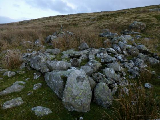
But then, there it is, a little distance below to my right. A definate, substantial cairn, although somewhat robbed internally. Tell me about it. Trouble is it appears to be very much a typical Bronze Age funerary cairn... that is ‘round’.... and not a long cairn. I could be wrong, I guess. But, checking the map, this is the spot all right. Perhaps significantly, the cairn is located on the north-eastern shoulder of a slope overlooking the Nant-y-Llys (stream) and appears to have been deliberately sited so as not to have The Snowdon Massif as its primary focus. Intruiguing. Aye, that is is. A fine, wild spot indeed.
Despite the conditions – or probably because of the conditions, if the truth be told – I would have stayed much longer if another ‘cairn’ hadn’t have been indicated on the map some way to the north...... Ha! These cairns are certainly more-ish. One is never enough, is it? Bit like Jaffa Cakes.
I was on the road by 5.30am in order to catch the morning light (should there be any) on the mountains, there was golden glow a plenty.
I came across this longcairn on coflein (bless ‘em)
whilst looking into the hut circle settlement in the valley below, at the time I thought, phwooar that must have a good view of Snowdon, I’d like to go there, so as soon as the weather picks up, and here I am.
I parked at the viewpoint on the A498 just south of the junction with the A4086 (Llamberis pass), perfect for both the longcairn and the hut circles.
There is no path to the cairn other than those created by pointless sheep, and its steep too, and when the ice thaws, wet . but the view from the top is the best in Wales, its not the top, rather a high plattau between the mountain tops proper and the valley floor, the cairn is obvious and easy to find, the longness to it is all but gone but it still makes a good round barrow.
I am inclined to beleive that this is the burial place of someone important who lived at the Cwm Dyli settlement in the valley below, from there the mountains peaks whose shadow they lived in everyday would have been hidden behind false hill crests, so where better to spend eternity than up here amongst the gods, just imagine if Bryn Celli Ddu or Pentre Ifan was up here there would be a road up to it, but i’m already sold, somewhere in this national park will receive my ashen mortal remains one day, and hopefully I can spend forever being blown from mountain top to mountain top.