Monday 2/8/04
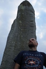
I drive down to Auchencorth Farm to ask permission to visit this stone and am greeted by a friendly old farmer on his quad bike with his sheep dog on the back ‘aye, you can jist aboot see it fae here’. I drive back up to the main road and wander across the empty moorland in the direction of the ridge of the Pentland Hills dodging the flying ants. The stone stands about 1.8 metres high and is rectangular at the base though tapers up to a point towards the SSE. It’s aligned SSE/NNW. There are three massive grooves on the east side about 1 metre long and up to 10 cm deep. Above the grooves a panel has been chiselled off and apparently there is the fragmentary remains of well-cut Roman capitals on it, but I can only just about make out one or two letters.
|
Saturday 24/7/04
I’d already biked about 25 to 30 K across some very desolate and remote country before arriving at the summit of Birkscairn Hill. As I near the summit the hills to the west open out into a giant bowl all dark and brooding. The wind up here is so strong I am struggling to remain upright and it doesn’t help that there is horizontal rain. The cairn itself has been much remodelled over the years and a modern summit cairn has been built from some of the stones- it offers a welcome shelter from the unrelenting onslaught of the wind and rain. The cairn still covers an area of around 10 metres in diameter with some large kerb stones amongst the remains.
|
Friday 23/7/04
On the right hand side of the road leading out of Peebles to Innerleithen there is a recess built into the wall to accommodate this massive quartz stone. The sign next to its says that it was an erratic deposited in the ice age and the first written record of the stone was in 1462 when it was used a s a boundary marker for the town. Such an unusual and large quartz stone (about 1m by 70 cm by about 2.5m) would not have gone unnoticed in megalithic times and it’s continuing use as a boundary marker in later times reaffirms this.
|
Friday 23/7/04
The forest opens out to a clearing to the east of the firetrack (again there are Forestry Commission ‘S’ posts around the site where they have cleared the trees from it). I climb up from the drainage channel at the side of the fire road and can see one of the ramparts due to the presence of many outer facing stones still in place. This settlement sits in a hollow with the hillside it is built on actually higher that it- so not a defensive position. The interior is irregular and there are no discernable features to be seen.
|
Friday 23/7/04
A very mutilated site caused by stone robbing, cultivation, planting and felling. There are many pits and tussocks in the interior, but nothing to interpret. Sections of ramparts still exist, but only to a height of less than a metre, the best of which (an it ain’t that great) is found on the NW side before the forestry plantation begins again.
|
Friday 23/7/04
A sort and steep climb up from Peebles Hydro Hotel and into Glentress Forest brings you here. The fort covers and area of around 250 by 195 feet and was once forested, but was cleared of trees in 87/88 to offer a grand view over Peebles and the Tweed Valley. The inner site has many ditches and bumps, but none discernable as hut circles.
|
Friday 23/7/04
Not a lot left of this settlement and even more difficult in summer due to chest high grasses, ferns and assorted vegetation. This site (along with the nearby fort) was cleared of trees in 87/88 and not much remains in the interior. The only real visible remains of the ramparts are to be found on the north and east of the site where the external ramparts still stand to a height of about 2.5 metres and the internal to about 1 metre.
|
August 97
Kat and I stopped off at this famous clootie (or rag) well on the Black Isle on our way to the fantastic Groam House Pictish Museum. It’s, er, quite a sight! The well is now a trough beside the road into which a natural spring flows. Then around about this in all the trees are thousands of cloots. From the usual hankies to old socks and even the odd tartan insole. The whole site is kinda disgusting, though it’s heartening to see the ancient ways and traditions still very much in use.
|
NT6765865982
28/11/02
After a days of hillwalking and visiting some megalithic sites at Whiteadder I make my way back down a track next to Bothwell Water. My attention is caught by a group of recumbent stones looking not unlike a ruined stone circle. I have a closer look and am surprised to find that one of them is cupmarked. There are five cup marks and although two of the larger cups look natural, the other three look classically megalithic to me. The stone is approximately 75 cm long, 35 cm wide and about 50 cm high. On the north face of it are two cup marks in a vertical line, 8 cm diameter and about 5 cm deep. On the west side, one large cup mark 13 cm in diameter and about 3.5 cm deep. There are three large earthfast stones next to this and many smaller ones around. This site isn't mentioned in the RCAHMS CANMORE database.
|
Friday 23/8/02
Atop Spartleton, the highest hill around the Whiteadder archaeological landscape, a cairn 17 m in diameter. Despite a triangulation pillar just to the north and a modern summit cairn built on top, the original cairn still stand to about 1.2 m. The view from the summit is amazing. I sit here for ages soaking in the scenery, contemplating the ancient land around, then plug into my CD player and let Godpseed You Black Emperors ‘Lift Yr Skinny Fists’ wash over me- a phenomenal soundtrack to an equally phenomenal land.
|
Friday 21/9/01
The last time I tried to visit this site was in the middle of summer- a bad idea. The whole well house was covered in vegetation, most of it consisting of brambles and nettles. The only thing which was visible was the finial on the roof known as the cardinals hat. I didn’t get very far before being scratched to bits! So a return visit in the autumn on the way back to Edinburgh after a visit to Traprain Law. This time you can actually see most of the well house which sits in a ditch below road-level. Most of the offending plant life has been cut back too so I can actually get round the outer wall. I shuffle round it on me arse and jump down to the well house. The well house is relatively modern and there’s a metal plaque above the door with a thistle motif which reads ‘16th century historic building’. For such a small well-house the walls are still 25 cm thick, and the building (excluding the roof) is 1.25 m high. An old iron gate, which seems to be permanently open, is attached on the left. Inside the well is almost filled in, though there is still water in the base.
|
Friday 21/9/01
In the hedgerow next to a quiet and lonely road stands this small megalith only about 50 cm high and almost hidden in the hedge and undergrowth were it not for the iron railings which surround it. Why on earth surround this small stone with tall spiked iron railings? Was it to protect the stone? From what? It’s a little used country road. Or was it to try and stop folk performing rituals and lighting candles here as could be seen from all the wax on top. A lonely and unsettling place.
|
Wednesday 21/7/04
I collect the keys from St. Margaret’s House in Lochend and drive up here. Restalrig has changed a lot since I were a lad! This part of the city has been beautifully renovated with lovely steel benches and some great masonry work. I make my way in to the churchyard and round to the wellhouse. From a wooden door steps descend down to an old wood and iron door. As I turn the key in the lock it echoes round the wellhouse behind it. The door opens and the air is damp and musty. A vaulted ceiling greets me and I descend the stone steps to the wellhouse floor which is slippy and slimy! The central pillar holds the five sections of the vaulted ceiling and high above on the left hand side there is a statue of St. Truduana. This wellhouse is actually below both ground level and the water table and therefore floods regularly. On the right hand side there is a large (and very heavy) stone slab which can be lifted to reveal the well/water table where one can bathe ones eyes.
|
Monday 3/5/04
I drive past this site (well, on the road waaaaaay above it) almost every day and finally get round to a visit. It's a long walk down from the road which climbs up the ridge of the Moorfoot Hills down to the peat moor. The views from here are stunning though- along the Moorfoot ridge, the complete skyline of the Pentland Hills, Berwick and Traprain Laws, Arthurs Seat and across the Firth of Forth to Fife- wow- what a final resting place. I follow the side of a new forest and trust my GPS to find the cemetery. At the end of the trees I start to notice circular patches of light green grass rising ever so slightly from the peat and short heather- just as well I visited at this time of the year otherwise the whole site would have been hidden in vegetation. There are apparently around 50 small cairns here, but I can only count about 30 or so- some of which I have to use my imagination! They only rise about 20 cm from the ground, but the largest is around 4 m in diameter. I guess most have sunk into the peat below. The whole site covers an area of 160 m NS by 70 m EW. Still- an impressive site with great views of some of the major archaeological and megalithic sites of the Lothians.
|
Monday 3/5/04
Driving up a dusty and hot track I can see the orange pipeline marker sticking out of the hedge- apparently where the remains of this possible stone circle were first discovered in 1994. There's a large tree next to the hedge and sure enough, there are three large sandstone slabs and many large stones at the base. I climb up the gate that overlooks the field and check around the pipeline marker, but all clear of stones, so I guess these must be them! The field next to the fence has been meticulously cleared of any stone remains. The large slabs are loose in the ground and lying horizontally, as are the large stones. I check all of them, but no marks apart from possible plough scrapes.
|
Friday 16/4/04
In front of me hangs a menacing bible-black sky, to the left, the Edinburgh City Bypass and to the right a landfill site. I follow the line of the pylons until it opens to a golf course. Heading up a small hill I am soon hidden by trees and following the arrow on my trusty GPS. The hill soon becomes a tangle of trees and bushes and it's a bit of a scramble through it all. Somewhere in here are the remains of 111 cists, at least one of which was built with a cup and ring marked stone and many contained Neolithic and Iron Age remains. The GPS tells me I'm on the site, but there is nothing on the ground I am standing on. I explore further as the site once stretched along the ridge of the hill. Unfortunately, a quarry has destroyed the SE section. It looks like the remainder has disappeared under the tree growth. I do, however, find rectangular indentations running approximately NE/SW- one of the few remaining graves? A mostly destroyed site unfortunately. Most remains have gone, no cup and ring marks and very little ground evidence.
|
Saturday 20/12/03
These two stones stand in a field at the southern ends of the hills of White and Black Meldon which are both topped with forts, and all around are settlements, hut circles and cairns. The stones are aligned N/S and are 2.1 metres apart. The northenmost stone is approximately 1.1 metres high and is very angular with almost small steps up its southern side. The southern stone contrasts this by being very rounded and smooth, leaning back to the south. This stone is slightly large- about 1.3 metres high. Between the stones are some large boulders- one of which has a cracking cupmark on it- but is possibly natural. There are stories of other smaller stones being associated with these. I am busy with my notes when I suddenly feel like I'm being watched- I look up and meet the stares of around 200 faces- a line of sheep all watching with intent as to what I'm up to in their field!
|
Saturday 20/12/03
Over hills past ancient cultivation terraces, over old bridges and past hill forts ringing the tops of all the summits around, the road I travel leads me to this huge stone. I park on a muddy verge and walk over to meet this beast. From the SE face of the stone next to the road, the full extent of this monolith is not apparent. Only about 1.2 metres rises out of the dry stane dyke. The wall into which this stone is now built runs NE/SW from its sides. The SE face has approximately 11 natural cupmarks on it. This is no accident on the part of the ancients, though we have now lost the significance of these marks. Jumping over the dyke and the electric fence the full majesty of this stone is revealed. I am dwarfed by its presence- almost 1.9 metres high. There are two possible natural looking cupmarks on this side, though quite small.
|
Sunday 7/12/03
Just over one hour of climbing up the Red Bull XC you reach the summit of Minch Moor at 567 metres. The beautiful climb up on singletrack gives way to an eye watering swooping bermy descent down to the Southern Upland Way, where, just over the other side of the Minch, the Cheese Well gurgles away. The sun has yet to reach this part of the hill and it's still frosty and very nippy. This is a fairly lonely and isolated spot, but the stunning scenery all around and the atmosphere here gives this place a, well, just one of those feelings- it's very hard to describe. There are two natural springs here- the flowing and gurgling one and a small pool which trickles. A small path from the SUW leads to the springs and two stones- one shaped like an old grave stone which is inscribed with "Cheese Well". The other is kite shaped with a fab thistle carved into it with "Cheese Well"and "1965". The sound of the water is mesmerising. I have no cheese for the wee folk, so I leave them a fizzy cola bottle instead hoping for a safe passage across their moor!
|
Saturday 29/11/03
After being in the car again for far too short a time to dry off at all, it's back out into the downpour and head up to a house called Warrior's Rest- at the corner of which is a standing stone. I head up the farm drive and about to go through the garden gate when the front door of the cottage is opened by a friendly face- I ask if its okay to have a look at the stone and take some pics- 'aye no problem- have you seen the other two stones just up the road- they're worth a look'- cool. This stone is right at the corner of the house. It's just over 1.5 metres high and leans slightly to the south. It has a very phallic air to it. The top is pointed and the east facing of the stone is smoothed to a ridge up and down the length of the stone. I have a good look over the stone and two small cupmarks catch my eye- these are just to the right of the ridge of the east face, approximately 2 cm in diameter and form and angle of approximately 45 degrees. I have a look through the CANMORE notes, but am surprised to find no mention of these- hmmmmmm. From this stone, the Yarrow Stone and the Glebe Stone are visible to the west- I head towards the latter….
|
|
|