Saturday 29/11/03
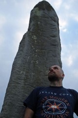
Between the stone at Warrior's Rest and the Yarrow Stone stands this monolith in a field of sheep. By now I'm soaked through, my CANMORE notes are rapidly turning to paper mache, my OS map is wringing and my camera is in danger of shorting due to the condensation and rain! This is a massive stone- biggest of the three in this area. It's about 1.3 metres high, almost the same wide and about 40 cm thick. Around the base of the stone are many small stones and boulders which look like field clearance. Towards the bottom of the eastern side are two cup-like marks- one of which is natural, one of which is classically man-made looking. To the ENE I can see a monlolith through the rain, to the WSW another….
|
Saturday 29/11/03
It's absolutely tipping it down. Not just heavy rain, but a really soaking down pour and it's been at it for most of the morning. I park at the end of a farm drive that takes you from the A708 up the farm of Whitefeild. Donning goretex layers, stuffing notebooks and maps well out of the rain and sealing my camera in a zip-lock bag I venture out of the warm dry confines of my car. In my infinite wisdom I have forgotten waterproof troos so after about two minutes my combats are uncomfortably soaking. I was planning to head up to the farm building to ask permission to have a look at this stone, but it's on the way up the track, next to the road and has a rather well tended wooden fence around it so I guess it's okay to look (plus I'm wet enough as it is!). The stone is around 1.5 metres high by about 40 cm thick whinstone block. Legend has it that this stone was erected to mark the grave of two British Christian Chieftains. There was, at one time, a Latin inscription on the eastern face, however, most traces of that have been washed away over time- you can just about make out some lines if you squint hard enough. I get the feeling that this is a Christianised standing stone, due to the fact that it was under the ground until the 19th Century, that there was meant to be around twenty large cairns on the same moor and that there are two other significant standing stones 500 metres and 750 metres to the ENE of here.
|
Friday 28/11/03
Another site which I have visited, passed by and played around as a kid on countless occasions, but never got round to writing fieldnotes or taking piccies until now. Plus, many times I've passed by with my camera in the summer the front of the well has been sealed off (to prevent folk drinking the water which gets full of algae in the heat of the summer). Well, the summer has definitely long gone and the iron shutters are off allowing you to see into the mini-vaulted roof of this well through the black grill. The water flows from a spout built into the main supporting pillar of the roof. The whole structure has a certain flowing feel to it due to the black railing which curve round both sides of the well house.
|
Sunday 16/11/03
This is one of those sites which I have been meaning to visit for ages, but somehow, I've never got round to it. The position of the stone is (was) great (now the view west is marred by the blot-on-the-landscape that is the Cardrona Hotel, plus it stands at the entrance to the new Cardrona village- a disgusting housing scheme for those with more money than taste). To the south is Cardrona forest, the north is the forest of Glentress and to the east the hills of Lee Burn and Lee Pen. The stone itself is around 1.3 metres high and approximately 1.8 metres in girth. It's now leaning to the north. CANMORE notes that it sits on the crest of a scarp representing the ancient course of the River Tweed, so it would have originally been right next to the water, but now is around 100 metres away.
|
Saturday 15/11/03
The firetrack next to the settlement is a section of the climb up to some excellent DH biking in this forest. I've passed the clearing on many occasions, known about the settlement from the OS map, but never connected the two. On climbing down from the track I notice a wooden post at a corner where the trees stop with the letter 'S' on it. Having a look around I can just see in the trees one of these at each corner of the clearing. Looks like FC marked this area out when they planted the forest. From the track you can see the outline of the external wall, but most of this has collapsed down the steep sides of the hill and into the forest. I could only find one stone on the southern flanks (although CANMORE mention three). There are also meant to be eight house platforms within the wall, but these are very difficult to distinguish due to the overgrown vegetation. The occupants of this place must have had an excellent view up and down the Leithen Water and across to Lee Pen, though the position is not a defensive one, unlike the two forts (the Pirn and Caerlee) only a couple of kilometres or so down the glen.
|
Sunday 2/11/03
This site is usually described as a 'runic cross'. There are no runes on it and neither is it a cross. It's a cup and joined-ring marked stone almost 1 metre high and oblong in section. It sits on a modern engraved sandstone plinth dwarfed by the church immediately behind it (one of my friends has the original plinth as a feature in his extensive gardens!). The cup and ring markings are executed in the classic style- by a pecking technique which makes me think that this stone is somewhat much older than the proposed 8th century- the design certainly is. All four sides of the stone are decorated with the same pattern. I can't find any evidence to suggest that this stone actually formed part of a cross- I guess it was assumed so as it was found in the foundations of an old church which used to stand on this site. However- how many churches have been built on top of Neolithic or Bronze Age monuments?
|
Sunday 2/11/03
A more grand and glorious well house would be hard to imagine- resplendent in the St. Ronan's colours of sky-blue and white with a huge royal coat of arms and flagpole. Unfortunately the well house closes for the season on the 19th October, however, on the veranda you can still partake of the mineral waters from a cast iron cistern built into the wall. There are also a couple of interpretive panels highlighting the connections with Robert Burns and Sir Walter Scott. The spa house was built in 1827, but the curative mineral water of the wells must have been a magnet for thousands of years.
|
Sunday 2/11/03
The usual way across the Leithen Water is blocked- the 18th Century Cuddy Brig is finally being restored before the whole thing collapses into the water. I wander up to Jenny Bapties Well and cross the water by the old stepping-stones. A short climb takes you to the summit of this hill, though on the way very little remains of the fortifications can be seen which used to guard this place. There's a great view across the town of Innerleithen and up and down the Tweed Valley and across to Caerlee Hill Fort on the other side of this glen. The twenty or so house platforms are difficult to see due to the thick ungrazed grass which covers the fort. There's a fantastic modern addition though in the shape of six carved stone plaques depicting life in Innerleithen from early times to the present day (including a beautifully executed salmon).
|
Sunday 2/11/03
Through St. Ronan's Wood I follow the sight of the communications mast that now sits on the side of this fort. The fort is now split in two N/S by a dry stane dyke. On the eastern side of the wall the summit of the hill has been fairly extensively quarried and much of the ramparts and house platforms have been destroyed. However, climbing over the fence, the original features of this fortified settlement are more apparent- you can still see about four of the hut circles and most of the ramparts. From the summit there is a commanding view of the Tweed Valley and across the other side of the Leithen Water glen to the Pirn Hill Fort.
|
Wednesday 28/8/02
Today I need to leave the city, just for lunchtime, but I need to escape. This place draws me like a magnet. Every time I lift my head from my PC or paperwork in my office, this ridge is there. It’s funny, I’ve always stayed in Edinburgh and I’ve always been interested in the surroundings hills, woods and country. I’ve often wondered ‘where is that line of trees on the horizon?’ It’s here. Where these rocks are. This is the place that holds the key. This is the site of the *interpreter*. I sit by the main cup and ring marked stone, place my hands lightly on it and close my eyes. I let the sounds rush in. My head is too full of fuzz though. I still leave this place calmed.
‘See for yourself the summer fields, before the tractor comes…walk along on your own’.
|
NT 1529 6838 Wednesday 28/8/02
The forgotten monolith. This site is not marked on the current OS map, or any other older maps I’ve consulted. Nor is it mentioned in ‘The Standing Stones of the Lothians’. Even in the RCAHMS database the last entry was in 1975 to state dimensions. This is a noble stone though- just over 1.5 metres high and almost diamond shaped in section with points aligned roughly NE/SW. A large section is missing from the base of the northern face. The rock from which it is fashioned has natural horizontal marks all round it approximately 5 cm apart. This monolith is surrounded by dead trees, brambles bushes and 2 metre high stinging nettles. Like many sites I’ve visited the past few months, it’s possibly best to try and find this one in Winter when the vegetation isn’t so prolific! According to the OS map there is a network of paths through this forest- aye- my arse! Thanks heavens for GPS is all I can say- I would never have found this site otherwise. The forest I’m in looks like it’s used by paintballers, though there is no one around today. I leaped over a stone wall to get into this forest- perhaps there’s an easier way in from the A71!
|
NT578741 Friday 23/8/02
Heading west along the road from Traprain Law a Scottish Rights of Way Society sign appears at the roadside- ‘Public Footpath to Standing Stone’. It’s along this path I head- it’s absolutely soaking and before long it feels as if my boots are full of water. I walk along by the hedgerows ever conscious of the bulk of Traprain Law to my left. Over the fields I can just make out the top of Loths stone peeking over a hedge. I come to the field and jump the gate then head along the edge of the field of golden wheat to the memorial to King Loth. The stone is about 2.5 m tall with sides aligned NNE/SSW (remembering that this stone has been moved). The edges of the stone are amazingly sharp- almost as fresh as the day this monolith was shaped.
|
NT 5793 7461 Friday 23/8/02
On the lower western slopes of Traprain Law is a small souterrain aligned N/S. This subterranean passage is only about 6 metres long, 60 cm wide and 90 cm deep- it’s large enough for a single person to crawl through. I don my caving boiler suit and hard hat and crawl in the chamber. Only about 3 m remains roofed with some very large lintels. The structure is similar to all other souterrains I’ve visited, apart from it’s size of course. At the southern end is a gap, then two more lintels and backfilling underneath. At the northern end is another gap, then one more lintel. The existence of this tiny chamber on this huge settlement and hill throws up more questions regarding the meaning of such subterranean chambers. It’s too small for animals, only large enough for one (or two at a big push) people. Sure, it could be used of the storage of grain, but would only keep a handful of folk supplied for a winter- certainly not the numbers that would have been living on the Law.
|
NT 5830 7474 Friday 23/8/02
Walking east along the ridge of this amazing hill I’m seriously considering doing this ritual. There’s no one around, no cars in the car park at the base and no one up the Law. The views around are fantastic today (though the Lammermuirs are still shrouded in hill fog)- the nearest sign of life is a tractor busy in the fields to the south way way below me and the A1 even further to the north. I reach the Maiden Stone- it’s a large vertical rock sheet that has split away leaving a gap about half a metre or so wide through which one should squeeze naked to bring both good fortune and to increase fertility. The rock is about 1.5 metres high, so any flesh exposed during the ritual is hidden (apart from the squeeze in and out of the stone). I sit at the northern end of the Maiden Stone- it’s actually quite hidden down in this hollow- before I know it the boots are off and it’s only a matter of seconds before I’m completely naked atop Traprain Law! I go into the Maiden Stone and make my way along, the rocks feels warm and smooth. I stop almost at the end and, well, I don’t make a habit of this, but I have to admit it feels amazing to be sandwiched in rock. I squeeze out of the other end and go back to get dressed quickly. I feel so empowered, so invigorated. I want to go through again, but decide not to push my luck- I don’t fancy getting caught doing this!
|
NT 646 678 Friday 23/8/02
I can usually battle my way through dense forest, but this is ridiculous. I’ve made it about 10 metres or so into the trees practically on my hands and knees and narrowly avoiding losing my eyes. I am soaking wet and according to the GPS there’s still another 60 metres to go- no way! Another site now lost in very dense forest.
|
NT 645 675 Friday 23/8/02
The GPS points me off the forest track and through head high bog rushes, down a fence line and to a sheepfold. Unfortunately, only 6 figure co-ordinates are available for this site. I search and I search- in through dense forest, around the peat bog, searching the grassy banks of the burns, but nothing. The OS couldn’t find this site back in 1979 and the description in ‘The Standing Stones of the Lothians’ doesn’t quite tie in with the co-ordinates given. I’m afraid it’s another site lost in now dense forest.
|
NT 6238 6671 Friday 23/8/02
A grass-covered ring about 12 metres in diameter is all that remains of this robbed cairn. It’s sited on the eastern slopes of expansive moorland just north of Whiteadder reservoir. Small stones still poke through the turf all round the cairn which still rises to a height of about 1 metre. The centre of this burial mound has long gone, but is now full of tiny purple heather blossoms…
|
NT 6540 6732 Friday 23/8/02
Way up on this moor, in the middle of these hills, seven small stones form an oval 9 metres EW, 8 metres NS. The stones are all set on edge or end, as many of the Whiteadder monuments. They only rise to a maximum height of about 25 cm. Along the northern arc of the circle I can see three earthfast stones (four have been reported) and approximately 10 metres west are another three stones (also earthfast).
|
NT 6645 6723 Friday 23/8/02
There are no paths to this place, no tracks up here. Just four fire breaks in this forest converging on the Witches Cairn. The way up to this site is really hard going- knee high grass and bog rushes, flies galore. I’ve got full water proofs on as the vegetation is so wet, however, it’s also so humid that I’m as soaking underneath! There is nothing for miles- forests, moorland and deserted farm houses. The cairn itself is a rough grassy mound about 21 metres in diameter and about 1 metre high. At the centre is a modern pile of stones- curiously one of these small (25 by 14 cm) stones has a deep cup mark on it’s upper surface (4 cm diameter by 3 cm deep). Approximately 5 metres west of this central cairn is a large boulder 60 cm long, 45 cm wide and 40 cm tall- on it’s upper surface is a large cup mark measuring 5 cm deep by 5 cm diameter. Measurements done, photos taken I pack my gear and leave sharpish, this place is giving me the creeps.
|
NT 6393 6697 Friday 23/8/02
The Herring Road track gives way to a beautiful purple heather path, the hill path gives over to moorland. The cairn is basically a heather covered mound rising out from the moor to a height of about 60 cm with a diameter of around 10 metres.
I am standing atop Spartleton Edge Cairn. No sounds, no sun, just heather and forests just visible through the swirling mists.
Desolation, desolation, desolation.
|
|
|