Showing 1-20 of 31 fieldnotes. Most recent first | Next 20 
We took this trip because Littlestone wanted to take some books down to the Samye Linge Tibetan Monastery. I checked for what was in the area as far stone circles were concerned and came up with the Girdle/Loupin stone circles. We stayed at Marilyn’s Motel in Eskdalemuir which consisted of two wooden buildings decorated in Tibetan style and very comfortable, though we were slightly squashed in the smaller building. Samye Ling was a mile and a half down the road, and a place to visit just for the joyous (and slightly over decorated temple) and also a vision of ‘wedding cake’ stupas.
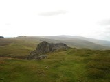
The landscape of hills, valleys and rivers is marred to a certain degree by industrialised forestry and yet the beauty of it all is captured as one drives along the lanes round here. The stone circles are easy enough to get to (and only about a mile from Marilyn’s) that is if you do not have a weak ankle! But glorious when you do get to them. Situated close to the White Esk river which burbles quietly over a shallow bed. This river in fact took the other half of the Girdle Stanes as it moved over the landscape through the centuries.
The story is that perhaps half the Girdle Stanes were taken by the river after which the Loupin Stanes were erected, there is supposedly a stone row joining the two circles, rather uneven, but it could also be interpreted as station stones along the way.
We are going back to this area, the Girdle stone circle is very serene.
As a matter of interest there is a prehistoric trail to take; three Iron Age forts to climb, and of course the circles and a settlement. Castle O'er looks good.
http://www.langholmwalks.co.uk/pht/sitelist.html
A Victorian interpretation!
https://archive.org/stream/langholmasitwashhysl#page/n37/mode/2up
|
The following was written in May 2011, and therefore is an old blog. All I can say though is that they may have built a huge building over it by the time we had left!
Today we visited Springfield Lyons just up the road. Set in the centre of business and retail centres this late Bronze Age enclosure has something of a wow factor close up. From the road you can see the large banks (spoil heaps from the excavation) that surround an inner ditch broken by 6 causeways. So a 'causewayed enclosure' maybe, but it must not be forgotten that it was also used by early Saxons as a pagan cemetery and later as a settlement.
A description of this site must begin with its half wild aspect, today you approach through thickets of blackthorn and briar roses, the banks loom large covered with similar material. The central rounded area is grass eaten down to the root, rabbits must run amok, if their pellets are anything to go by. LS also glimpsed a fox, in excellent condition, his restaurant was well stocked!
The ditches had some water in them and reeds testified to their marshyness, but of course in these drought months we are experiencing the ditches are drying out.
It has been excavated in the past several times, and the ground is full of holes in which regenerating elm tries to take hold. The explanation given for the late Bronze Age occupation, (approximately 800 bc) is that it may have been a fortified stronghold for a local chief. Excavation has shown that there is a large central hut facing the gateway with an elaborate porch, which would probably have been his home. There was also a working area and it was here that two moulds for making swords were found at the terminals of one of the causeways, of a type called Ewart Park, but no metal elsewhere.
There was also evidence of Iron Age recognition of the site, a 'broken' sword was found in the centre of the circular area in a pit and further to the west of the pit a horse skull was found with an iron bit and two studs. Presumably a ritual burial of some kind.
The banks are in fact very large spoil heaps, the actual bank would have been inside the segmented ditches. There would have been a wooden type 'verandah, all the way round the bank, giving a roofed walking/working area. Looking at the interim report on the excavation, and an artistic representation shows a very neat settlement set in an idyllic pastoral countryside. There is also an early photograph of the fields before development took place and it descended into what we see today. The area had been ploughed flat over the centuries before the excavation, so what we see now is the excavated ditches.
The pagan Saxon cremation cemetery had the usual range of intricately worked Saxon brooches also metalwork, including a funny rounded hat and of course beads, twelve strings were found, and it is though that the beads hung between pairs of the brooches; the brooches of course clasping the dress at the shoulder. There were some 225 certain or possible burials,of which 103 were certain inhumation burials but the cremation pots had been buried very close to the surface, and the surface was to a degree ploughed out.
Given its close proximity to houses, there is a lot of rubbish around, some dumped in the ditch, and the site looks distinctly uncared for. Not sure of its scheduling as far as a monument goes, but it is in grave danger of being built over.
Just down the road, and starting from the Asda car park is a Neolithic cursus, excavated about 30 years ago, when this area of suburban houses was being built, it followed the line of the river before you reach the mill at the Fox and Raven pub.
Interesting in itself but not part of this blog. Now whether this earlier monument had anything to do with the settlement at Springfield Lyons is a matter of conjecture.
Edit - a link;
https://theheritagetrust.wordpress.com/2012/08/07/the-chelmer-springfield-cursus/
|
Extract taken from a paper read to the (archaeology) society April 5th 1832
"At the north end of the parish of Ashdon, in Essex, are certain artificial mounds. They consist of a line of four greater barrows, and a line of three smaller barrows, at the distance of between 70 and 80 feet in front of the others.
“The situation of these mounds is remarkable. They stand on a general acclivity in face of Bartlow church, the country gradually rising around them like an extended amphitheatre.
“Between the hills and the church is a hollow to the north, down which runs a little brook that divides the parishes of Ashdon and Bartlow, forming the boundary of the counties of Essex and Cambridgeshire.
“Though the hills do not belong to the parish of Bartlow, which is in Cambridgeshire, nor to the hamlet of Bartlow which is in Essex, still, from the received interpretation of the Saxon word Low, a barrow, it is clear that they give their name to the place, a proof of their antiquity”.
Should they be on TMA these early Romano-British mounds, unique of course, and large. But in truth they have to be seen just to say 'wow'.
Second visit and we always start from the church, past the Three Hills pub/hotel, turn right at the cross roads and the church will be on your right. Stand and admire the round towered church, note the two paths that run through the church yard, one will lead you to christianity, the other to a pagan past.
The remaining three mounds are surrounded by tall trees, an ecosystem has evolved in this large glade the chalk mounds are covered in long grass and wild flowers, this is what enchants the place. Butterflies dance at your feet, there is a surfeit of these dark brown creatures, damselflies and dragonflies from the nearby stream, bees buzz busily round the plants.
The three mounds so steeply sided protect the plants, Silbury comes easily to mind with the largest mound, at 45 foot high, though the Bartlow mound misses the mark it still comes second, you can read the history here.....
http://www.sheshen-eceni.co.uk/bartlow_info.htm
I suspect winter would be the best time to visit, shorn of the natural vegetation, but summer has the added highlight of a vibrant ecosystem on these mounds.
|
This mind visit will be a pleasant memory of the moors plus friends and unexplained enigmatic stuff, no ghost stuff of course, just a rectangular megalithic enclosure that defies explanation sitting in a bowl of hills.
Where to start, we met at the Trippett stone circle and followed Roy (Sanctuary) in the car and we kept turning right, again and again through tiny foxglove filled Cornish lanes slowly circling the moor, until we came to a track way that reached up to a ridge. The cars bumped up this disintegrating road, just below the ridge was a scatter of rocks, and here we later found Bronze Age cists, and apparently settlement sites according to the map.
Reaching the top of the ridge, we looked down to a small hamlet of three houses, crossing the small rocky beck that tumbled down, the cars were parked on a small green plateau, next to a land rover sporting the title Cornish Heritage and we were to meet the foreign tourists and their guide at the site later on. Even the vast empty spaces of the moor have life and visitors.
Walking uphill past the inevitable cattle, sheep and ponies with foals, we could see the grassy outlines of KAH in the distant a short walk of about 15 minutes. Climbing the stile and the first feeling is enclosure, you are surrounded for three quarters of the way by the rise of hills, and over in the distance behind a thick swathe of dark green forestry firs is the Stripples stone circle/henge monument which we did not see but is the only henge monument to be found in Cornwall at this time.
The large untidy bank that surrounds the stones, causing many of them to keel over, and the walking path below the bank is difficult with great tussocks of grass and hidden stones. The theory is that this large enclosure was dug out maybe for water. (who knows) and the central area is boggy, reeds outline the boggy area and cotton grass was in 'flower' blowing gently in the wind, and just at the centre of this area a darker green patch of vegetation which meant deeper ground and water, the dogs drank from here.
A few words from the rather scant Wiki; "The monument consists of fifty-six stones arranged in a rectangle with a bank of earth around them and measures approximately 20m by 47m. The interior fills with water and a contemporary ground level has not been established. It has suffered damage by cattle in the past and is now protected by a gated fence. It can be reached by footpaths east of St Breward."
There is a report by an archaeologist that gives the theory that in actual fact this is a medieval pound for the cattle up on the moors, and that two manors whose boundaries met here would have problems with straying cattle and they would be impounded, of course one would ask would it not be difficult with boggy ground and water to keep cattle there.
Feelings tells you that this is a ceremonial prehistoric monument, surrounded by stone circles on Bodmin Moor, there is a certain timelessness, stones cluster at the corners, there is a similar rectangular enclosure in Brittany, and apparently also at Lough Gur in Ireland, but until archaeological excavation proves the point one way or the other there is no answer, only that wild moors and megalithic monuments have a symbiosis that is magical.....
|
We arrived in the village of Minions in cold, misty and very windy conditions. The moors around sported farm animals and ponies, this part of the moor it was the banded white/black cows that were in evidence. Small ponies everywhere, their foals at heel or fast asleep in a hollow of the land whilst their mothers grazed.
Great excitement on my part for eventually arriving in Cornwall, the Cheesewring pub/hotel was very welcoming, room good and the food fairly good as well - pub fare.
How to describe this landscape, dystopia kept coming to mind, the land has been mined for tin and ruined engine houses dot the skyline. Yet of course it is beautiful, the mine workings flow through the land as bumps, ditches and small pits filled with reeds and water, a green and pleasant land, the mist adding to the romantic industrial tone of the place.
The Hurlers Stone Circles, there are three, though one has almost disappeared, is about 5 minutes walk from the road just outside the village and they lie about half a mile from the Cheesewring, upon which of course they are focused. What went through the minds of these stone age people as they looked on the weird shaping of the Cheesewring, honed by time and geology to a 'topple' of stones balanced precariously on top of one another. Did they think their ancestors had built such stone gods? Giants placing each stone carefully, who knows?
On our first visit, the mist came and went so that sometimes the blurred outlines of the Cheesewring was there and then would completely disappear, we had come in the time of the summer solstice, but the sun had decided not to make an appearance. We met at the stone circle someone from the forums, who were also there for the summer solstice.
The two stone circles have a feeling of serenity and you can fall in love with them quite happily, they pull you in, they are not showy circles just part of the landscape and as you glance over to the two Piper Stones in the distance the question asked are they both part of the same equation, or are these two stones something different.
As we spent three days in Minions village, we
visited several times, and also walked to the Cheesewring in blustery weather with Sanctuary and his dog Chief. The front half of this great outcrop of rock (sorry don't do north, south, east and west) has been heavily quarried right up to the strange assemblage of stones before it was finally stopped. There is an early neolithic wall fronting this and several upright stones balanced precariously on the edge of the quarry, this is part of Stowes Pound Neolithic enclosures.
Silly people were doing the 'Titanic' act of standing on the Cheesewring with arms outstretched in a gale force wind, hopefully should they have been blown off there is a helicopter service in Cornwall.
Definitely going back!
|
Our short Cornish trip revealed some treasures, the Hurler stone circles certainly being one, but further on the Rillaton Barrow situated between the Cheesewring and the stone circles was certainly a barrow not to be missed.
Description aside, this large, untidy, desecrated barrow shown by our good friend and guide Sanctuary, did make my heart miss a beat. Reading up on it, and I find in was restored in 1900, and had some archaeological work done in 1995 to the entrance, this may have detracted a bit, but still.
Firstly this enormous barrow is pitted with stone robber pits, a reed filled pond lies in its centre and the entrance pit has been raised up so as to stop school children* going into the hole and damaging the inside stones and the fluorescent lichen, which gives a ghostly green glow inside the tomb. The rather neat internal stones have ferns growing against them, and our proud warrior with his gold cup and bronze age dagger lies buried between the Cheesewring and the stone circles, also has a marvellous view to the front over the surrounding countryside.
* Not only school children, see a couple of TMAers have also squeezed in - tut, tut. Just use your camera for goodness sake......
Interesting information of the work done in 1995.
www.cornwall.gov.uk/idoc.ashx?docid=470eb27a-37f3-4d2d-8810...?
Copy and paste
|
We took the little lane from the A171 to the A174 going through to East Barnsby. Beautiful May morning, three fords to cross, Yorkshire at its best down in to deep old dark woods, with bluebells, wind anemones and ransom on the verge, tumbles of old trees and water, what more can you ask after all that cold weather.
We met the kindly farmer's wife and got permission to cross the field by the education centre and into their field of sheep. The stone sits just below the highest point, square and upright, glittering in the sun. The lambs dance around in the field, some posing by the stone, but it stands strong.
Taking one's bearing as you look towards the sea and the Goldsborough Lane that you must take to find the other stone, it has probably been there as a track for hundreds of years.
We drove along the lane and saw the North stone in the distance, it is on the other side of the narrow wood or Carr, strange that they are so similar but had something else to do so another visit one day.
One reason we went out was because this stone is the flagship for the restoring of Ancient Scheduled Monuments under the North York Moors Monument Management Scheme, £200,000 is on the table for various schemes, including a 3,500 year old cairnfield with burial mounds.
Also the footpaths have been repaired at the Bronze Age burial mounds at Lilla Howe, Simon Howe and the Two Howes on Goathland under this scheme, presumably because people are WALKING OVER THE MOUNDS, Wales is obviously not the only place to have this problem.
|
Seahenge. Of course it is not a henge, not even a stone circle but built with wooden posts around the spring of BC 2049. The diameter of the circle was 21 feet (6.6m) with 55 closely fitting posts the circle averaging out at about 10 foot high. The land on which it stood would have been different, saltmarsh protected from the sea by sand dunes and mud with a mixed oak woodland nearby. Tis a place of sacred unknowingness, you may laugh but that central upturned trunk its roots reaching out to the sky must hold some sort of secret. The archaeologists think that it was used for excarnation, either for a great chief, or maybe for the small group or clan who lived here.
When I first saw the upturned tree, my initial reaction was that it was somehow a dinosaur, not quite dead, still throbbing with slow life. It has PRESENCE this tree, blackened and deeply fissured with age and a few model carrion crows perch menacingly on the edges of the mock-up wooden circle help create the drama. The tree stands in its glass cage watching over the recovered wooden posts of the circle as they curve round on their stand backed by a large photographic representation of the beach on which the circle was found.
This beach at Holme-Next-to-the-Sea must be your first port of call, drive down to the village and turn left at the crossroads, (where it says Peddars Way) and there is a car park further on. Walk over the wooden boardwalk by the dunes, the sand stretches for ages down to the sea, and on the horizon about 50 sea wind turbines stand like ghosts, blades idly turning. No mention of where the posts were found on the information boards, and I suppose if you were lucky and walked further on and the tide was out you may find the second wooden circle, called Holme 2.
There are several theories mooted on the boards that accompany the timbers, one is to do with the stripping and non-stripping of the bark off the posts, most timbers had their bark left on but one had been stripped, this one called ‘timber 30’ had its outward facing bark stripped, maybe to represent an important person, maybe because it had been struck by lightning thereby leaving a white bark. Firstly, it was said that the closeness of the posts could be that the whole site was supposed to represent a tree stump, or maybe each individual post represented a person, there were 55 posts in all. The orientation of the first timbers sunk was to the Midwinter sunset in the south-west and the Midsummer sunrise in the northeast.
About half the timbers were placed upside down, it could have been due to the fact that if driven into the ground right way up the circle would have leant inwards towards the centre. By placing them upside down they cancelled this inversion, but there again at other Bronze Age sites inverted objects were associated with death and human remains.
The narrow ‘entrance’ double pronged timber was labelled 35/37 in the initial excavation because it was thought to be two separate posts, there is a blocking timber 36 in front of the entrance.
The great central oak stump, over 50 axes were used on this tree, and 3 holes bored into its lower trunk show where it was dragged by honeysuckle ropes. Measuring about 2 and half metres high by approximately the same width, think I read somewhere it was 150 years old, there are two suggestions for why it was used, one being the excarnation theory the other “a symbolic representation of the fruits of the earth and the magical powers of trees, or perhaps a gateway to the underworld”
What to make of it all? Firstly, one has to agree with the decision of digging the timbers up, if only to help keep them for future reference and safe from further destruction by the sea, and because of their special uniqueness. The heart does stop for a few seconds as you view these old monster wooden posts, my first impression was of the old wooden Scandinavian gods found in the bogs – strange twisted and shaped… Alien, scary and dark! Imagination can run easily with Tibetan ‘sky burials,’ especially as part of the exhibition houses another upside down tree trunk to make the point that the roots easily cradle a human being.
Lynn Museum can be found to one side of the bus station, so simply head for the train and bus station and park in the car parks round there.
|
Not much to add in the way of fieldnotes, except to say that Merrick's bluestone is probably the spotted dolerite type. Above the tomb is ankle-breaking rock and heather, the view is of course magnificent. I walked up from the lane, along the path past a small derelict schoolhouse. Glyn Daniel who gave the name 'earthfast' to this localised crop of tombs, goes on to say that they come from the sub-megalithic group which existed in western France, Wales and Ireland; he plays around with terms such as primary, demi-dolmen, or half-dolmen. They do seem original 'cave' tombs, giving them a somewhat primitive feel. But like Carn Llidi tombs they hide themselves from view in a jumble of rocks and are often difficult to find.
Not far from here are are the Garn Wen tombs, there are three in a row (SM 948 390) sadly you won't be able to find them for they are covered safely in a thick vegetation of nettles and brambles.
Safely, because they back on to council housing, and the area in front of the cromlechs is used for a motorcycle track and tipping.
At Garn Wynda I had jammed the car key in the door lock but deciding not to panic had managed to work out how to unjam and vowed there and then NEVER to lock the car. Arriving at the council estate I asked the road sweeper, how to get onto the coast path, giving me instructions he warned me not to leave anything in the car and to lock securely (did not). But coming back to the car three children who had been watching me intently, yelled back to their mother, 'Mum she's back in her car'
So if you really want to find these three take a sickle. ;)
|
Take the road to Priddy from the Wells Road, and as you drive through this stonewalled landscape remember that you are entering a truly prehistoric landscape that goes way back into the past. Barrows, swallet holes, Priddy Circles and of course caves and rock shelters.
If you drive into the village of Priddy, stop for a moment and admire the large village green with an old fashioned farm on the other side. Drive up the hill to the church, and there is a barrow sitting in the field next to it. But to find the lane to Ebbor Gorge, you must take the first lane sharply left just as you enter the village, drive past the picnic place on the highest point of the hill, and descend down for a few hundred yards till on the left there is a car park for the Gorge.
The "scramble" walk is well indicated, you descend into the wooded depths of the gorge, high trees, dark green luscious growth and ferns on old fallen trees, patches of open ground gleaming pale in the sunlight, the white perfumed meadowsweet that loves boggy ground is on show. Then the scramble, you enter the narrow defile of the gorge where the shelters are situated, and begin to climb sharply over great natural stone steps with the sheer rock faces on either side, where there is sun the blue flowers of the nettle leaved bellflower cluster at the path's edge and a small stream trickles down the steps, at one point the path becomes so narrow between the rocks that it looks impassable.
The shelters are dark and gloomy places, Victorian grottoes comes to mind, Neolithic and Bronze age finds have been found, perhaps they were more burial place that living quarters. Upwards to the viewpoint over the gorge itself, steep, steep cliff like faces of rock covered with vegetation and tall trees in the gorge below, gives it a rainforest look and of course there is also a misty view to Glastonbury Tor with Wearyall Hills' long length blending into the landscape.
If you drive back to Priddy you should see some of the Nine Barrows on the horizon, turning left from the carpark takes you to Wookey Hole, and not too far away is Westbury Sub Mendip, where I believe half million year old bones were found…..
Its a middling demanding walk, steep paths and a bit of rock climbing.
|
Carreg Samson is a favourite, wander round the cliff path from the village, the farmhouse route looks pretty boring. Chunky is the best way to describe the dolmen, standing at the head of a small pretty valley that runs down to the
sea, the great capstone perched on three of the seven large uprights forms an oval/polygonal chamber. It dips towards the bay and Strumble Head, dominated by the peaks of Garn Fawr, Garn Gilfach and Garn Wnda, again the siting of the tomb is not on high ground, its reference point seems to be easy accessability to the sea and stream that runs down a few yards away. The chamber being constructed over an irregularly cut pit, stones that may have been found in the chamber could be put down to the fact that it was recently recorded that it was used as sheep shelter and had drystone walling inserted between the stones. There is no direct evidence for a covering mound but Nash suggests that the elongated shape of the stones points to a covering mound, not unlike Pentre Ifan
Three of its stones are of similar material and stand in a small row together, whether these stones are part of an earlier monument I don't know but Figgis says
that there was some mesolithic flintwork found within the tomb, so perhaps it points to a 'returning place' which had special significance.
ref; Neolithic Sites - Geo.Nash and Geo.Children
Prehistoric Preseli - Figgis
|
This is a chambered long cairn and the remains of its mound can still be seen. Set high on a hill, with, at the moment,(which must have been in March 2007) hundreds of sheep and lambs cavorting around, this is one of those spectacularly rocky places, with stones protruding from the ground everywhere. Soft turf and chunky stone walls add to the charm of the surrounding rather deserted countryside. The capstone looks rather like a flying saucer, elegant with two shaped orthostats framing the stone portal door, this is seen as a sophisticated design, but perhaps we are looking with modern eyes, given the chunkiness of Coetan Arthur and Carreg Samson's capstones, the ideal of beauty is in the beholders eye. Who is to say; maybe the neolithic builders felt that the erection of great heavy capstones was a work of great physical strength and prowess and deemed far worthier than puffs of the wind sailing capstones that Pentre Ifan represents.
Its capstone is tilted towards the Afon Nyer Valley to the north, the chamber being about 3 metres long by 2 metres wide. It was originally cut into the ground about 40 cms and lined with drystone walling, but has recently been infilled.
There is a blocking stone(doorway) in the forecourt area. Apparently there is supposed to be a cupmark on its outer face, but have stared long and hard could'nt find it- so I shall put it down to wishful thinking on someones part.
According to Nash it is a terminally chambered long cairn with a semicircular forecourt set in the southern end of the barrow - a Closed Portal Tomb. Glyn Daniels compared it to the so-called "horned cairns" of Carlingford in Ireland. Not surprising really its just a short hop over on the ferry to Ireland. Interestingly he also suggests that our more easterly Severn-Cotswold tomb group is derived from the Pentre Ifan type, perhaps that is why I am always drawn to this part of Wales - the sense of the familiar.
Grimes, another archaeologists who trod the ground round Somerset as well, excavated in 1936 and 1958, and he described the forecourt where ritual feasts may have been held, it consisting of two orthostats placed either side of an entrance, itself blocked by the massive 'closing' door. This door is of course speculated upon wildly by archaeologists, maybe it was open on occasions to bring in bodies that had been stored elsewhere. Maybe, it was a great chieftans tomb, with his retainers being sacrificed with him (bit dubious). Or in fact was a false door, the bones of the dead being inserted from the side of the mound, similar of course to the Rodmarton 'porthole entrance' or the Lanhill longbarrow.
The mound does not survive, but could have measured about 40 metres long by 17 metres wide. There are traces of kerbing stones, but they do not always align with the mound, and it could be linked with possible ritual pits.
Nash points to the dip in the capstone and the slope of Carningli, both point to the sea and the Afon Nyer Valley. This I could'nt see, being misty and very cold but I did find one of the fallen stones rather beautifully white with lichen and, a bit like a 'jewel 'stone, a rather rounded female stone
p.s.N.P.Figgis in Prehistoric Preseli gives another theory; there is a fallen stone, that remained in situ as the stones of the burial chamber were put up. This may have been a first phase, a single standing stone with a fire pit near to it, making this a dual mortuary site, or at least, a site that was in use over a long period but again all conjecture, with the stone being part of the first chamber building and single unembellished facade, with short mound. "The latest elongated tapering mound, and the elaborate facade covered the whole of the earlier structure".
ref; Prehistoric Preseli N.P.Figgis
Neolithic Sites - Geo.Children and Geo.Nash
|
When people write about this small dolmen they talk of mushrooms and fairies, and it does indeed sit tranquilly in its own little garden surrounded by a surburban small settlement of bungalows. Coetan Arthur was excavated in 1981, there had been a build up of plough soil over the centuries and in fact, the stones would have had another metre added to their height originally, making them much taller than they are today. There are four stones theoretically supporting the capstones, but only two are in contact.
One of the marvellous things about neolithic builders, is their ability to balance a huge capstone on a fine point. Think of a stiletto heel, its fine point bringing all that excruciating pain on to someone's foot, the weight of a person concentrated on a small round five pence bit. So it is with the capstone pressing its enormous weight down, thrusting it through the upright to secure thousands of years permanency - it gives one pause for thought.
Carreg Coetan Arthur is low-lying, just eight metres above sea level, close to the Afon Nyer estuary and about half a mile from the coast. To the south is Carningli, and the usual legend has been attributed to the stones, that they were thrown from the summit of the mountain. According to George Nash, the capstone when aligned with Carningli peak seems to match it.
Turning to N.P.Figgis on the subject, he cites a recent excavation which gives Carreg Coetan Arthur a somewhat different history. It had been presumed up till recently that the tomb had a closing 'portal door' and that its corresponding upright stone had disappeared, it was in fact an 'H' shaped portal dolmen similar to Pentre Ifan. It seems though that there never was a third stone, so no portal door. An arc of small stones had been laid like a kerb to the south round the remains of the mound, and between it and the now supposed 'front' of the chamber a space had been cleared. In front of the chamber had been a platform with some pottery and 'clumps' of cremated bone.
Radio-carbon dating gives the early date of 3500 years old for the construction - middle neolithic. But also inside the chamber there had been found much later Grooved Ware and Beaker Ware, showing that it had been in use over a long period of time.
Figgis goes on to speculate that perhaps we should not fall into the easy trap of labelling these sites as chambered tombs, but that they may have had a mulitiplicity of functions, which is little understood today.
refs; Neolithic Sites of Cards.Carms.Pembs.by Geo.Children and Geo.Nash; 1997 Logaston Press.
Prehistoric Presili (a Field Guide) N.P.Figgis 2001 Atelier Production
|
Cherhill Down is a place close to my heart -might even get my ashes scattered up here one day - as a landscape its totally weird, those folds of the hills that seem to draw you down into a vortex. The hillfort when visited last November was full of sheep and the day was misty, its part of the Avebury landscape that is thankfully untouchable because of the terrain.
I can see the monument from the downs round Bath, a good 30 kms away, and it is always a reminder of the nearness of the prehistoric settlements round here, Avebury, the Mendips, Cotswolds, Stonehenge and Salisbury Plain. The movement of people through the high lands with the marshy ground below, visiting each other at certain times through the year,, generations of people living in a landscape that provided for them. They melded the land into a place of permanent homestead, from the early beginnings of the causewayed enclosures of Windmill Hill and Nash Hill down to these large defensive iron age hillforts.
Practical facts; 25 acres defended by two banks and ditches, with an inturned entrance on the East. Area enclosed is divided across by a small bank and ditch running N/S (probably not contemporary) Pottery of 2nd/3rd century bc has been found in rubbish pits inside.
|
There has been a slight change of footpath's since Earthstepper's 2003 visit, as you turn right into the wood, before the house, follow the steep path up into the wood for a short while but turn left up the track. This will bring you to the farmhouse that lies behind the fort, (its best to go thro the rough grass/trees not across his mown lawn bit!) there is a little gate into the field. This is the north entrance into the camp, there is a small bank traversing the centre of the camp, which lines up with the east entrance. North and south defenses, the ridge on the west side overlooks the Bristol Plain and has no bank. Banks were covered with sweet smelling Ladies Bedstraw.
Brooding on the moment in time when iron age people took to the high places the question must be asked why. Social change, population explosion, lawlessness, climate deterioration or warfare, so that people, foodstocks and animals had to be protected. Little Sodbury is a big place - 22 acres - Horton and Dyrham forts just down the road. Were they palisaded enclosures, noisy with people and animals, the stench of both human and animal manure thick on the air, ruled by a tribal head, its an intriguing part of our unknown history. Visiting these places today, all soft english countryside farmed neatly we should do well to remember their past often violent history.
|
|
The hillfort is situated on a spur and faces west overlooking the Bristol plain, focussing on the gap between two hills on which a clear day the welsh coast can be seen. Said to be one of the possible sites of the Battle of Deorham AD577, where three British kings were defeated and Cirencester, Bath and Gloucester were lost to the West Saxons. More factual, is that Hinton, like Old Sodbury fort and Horton Camp all lie near to the A46 road. Solsbury Hill also guards the pass which runs through the valley overlooking the A46.
|
Good Friday 14th April 2006. The date is important, because as I walked up the steep lane met a lot of friendly people coming down. Arriving at the top, someone stopped to talk to me, and explained what was happening. An open air church service, followed by a picnic and kite flying for the children. Everyone had walked round the different churches in Batheaston, a service at each one and carrying a wooden cross, then they had walked to the top of the hill with the cross. It was extraordinary touching for one who does'nt believe; I likened it to the pagan festival at Avebury, which perhaps was'nt the wisest comment but she agreed..
I record this because it is part of the hills history and local togetherness, which is repeated every year.
The maze has been burnt at the entrance, either in some symbolic act, or wanton malice, but I'm sure it will mend with time.
Wandered round the ramparts which are very impressive and took a photo of Bathampton Down's celtic field system on the other side of the valley.
It was possible, the air was clear after rain, to see to the older prehistoric Priddy landscape, Penhill TV mast, with a longbarrow on its flanks and to imagine the 4 henges that are close by and the bronze age burial mounds. To the south, the landmark to look out for is the Lansdowne? Obelisk on top of Cherhill down, there's a clump of trees in front of it. Perhaps the smoke from prehistoric settlements could be seen from a long distance. Solsbury, Avebury, Priddy and Westbury, especially at night the fires would have been very noticeable.
|
This is approximately a five acre enclosure, fairly triangular with a steep drop on the other two sides, Bank is still impressive, it maybe that this site belongs to the same time as Old Sodbury Camp, (250bc-50bc according to James Dyer) There is a longbarrow above the church at Hawkesbury, which is about a mile down the road.
Longbarrow ref; ST768 871. It sits high on the hilltop, somewhat reminiscent of Adams Grave.
There is also another longbarrow marked at ST777828, Grickstone Farm but this has only one stone remaining, see Rhiannon's information.
|
This small camp must have been a fairly attractive place to live. Screened from the wind and facing inward towards the land amongst a jumble of rocks, it would have been difficult to find. Spent some time up here watching small birds feeding in the boggy wet ground, it has enormous presence this rocky outcrop, peaceful as well.
Not so peaceful (reason I am writing this) is the walk up the cliff path, 18 inches wide and a vertical drop to the sea, for those who suffer from vertigo take a different route. At the stream below turn right up the valley and then head back to the headland along the top.
Cunliffe -Iron Age communities in Britain; to quote;-
A complex rampart protected a small group of 6 conjoined
stone wall huts 5-20 ft in dia., excavated in 1900.
Sparse finds;- whetstones, spindle whorls, hammer stones and fragments of iron, plus a few glass beads.
|
|
Visited Knap Hill early in February, a cold misty day and most of my photos reflect this. Adams Grave is probably contemporary with Knap Hill and the landscape round here is luminous with the past. If someone from the neolithic past had sat down beside me and Moss on top of that hill I would'nt have been surprised. We would both have been looking at a lunarlike landscape, hills and downs defined by sharply etched lines that meet the plain below. Perhaps in neolithic times the land below would have been marshy and tree covered, but in the distance Picked Hill would have stood out, as did Silbury in its time, was it a sacred hill? could the inhabitants of Knap hill look out and brooded on the meaning of life as they went about their daily tasks - who knows.. But this area is so imbued with man's need to imprint himself within the landscape, The Wansdyke on the other side of Adams Grave reminds one of this. The colossal effort that went into making one's mark, whether in death, or defence, or as a boundary to define the edges of territory.
|
Showing 1-20 of 31 fieldnotes. Most recent first | Next 20 |
http://northstoke.blogspot.co.uk/
|