Showing 1-20 of 62 miscellaneous posts. Most recent first | Next 20 
If you are interested in wells, then just before you get to the village of Duloe, take the right hand lane (to Herodsfoot) from St.Keyne, and along that lane you will come on a very pretty moss and fern laden well of St.Keyne's. Robert Southey's poem will explain the consequences of getting married should you drink from the well.
http://www.poetryatlas.com/poetry/poem/1013/the-well-of-st-keyne.html
|
The Old Wife’s Well lies under the dreaded heading ‘Site of Disputed Antiquity’ and of course it is but its location next to a flint Mesolithic site and an old Roman road??? - See below for another explanation - gives it validity, and anyway it is a source of local water for those who have lived or passed this way over the moors, not forgetting the way marking, very probably prehistoric stones, that can be found a couple of miles on along this lonely stretch of moor and also of course the burial cists that can be found under the stone track way.
It is difficult to find the well though it is only a few yards from the road but buried inside the forestry trees. There is a forestry track way where you can park on the right just out of the village of Stape, walk along here if you want to see Mauley Cross. To find the well, turn left on the road towards the village and walk a few hundred metres along it, to your left you will see a faint path which will lead to the well. The well has it ‘clouties’ hanging on nearby trees, so does have visitors. Before the vast swathes of the forests were planted around the 1920s on the moors, this would have probably been farm land…… So maybe the spring of water with its unusual inscription may in fact be part of a much earlier prehistoric history…..
As the Roman Road/causeway does not appear on TMA here is the explanation for the Wheeldale Linear Monument being interpreted as a Neolithic boundary structure, and mentioned by Fitz..
https://en.wikipedia.org/wiki/Wade%27s_Causeway
“here are some objections to the interpretation of the structure as being a road at all, including the fact that several burial cists along the structure's course protrude through its surface by up to 0.4m, highly unusual for a road surface. Since 1997, authorities including English Heritage have accepted the possibility that the structure may not be a road. Archaeological consultant Blaise Vyner suggested in 1997 that the structure may be the collapsed and heavily robbed remains of a Neolithic or Bronze Age boundary wall or dyke. There are other Neolithic remains on the North York Moors, including boundary dikes, although Knight et al. report that the later Neolithic is very poorly represented archaeologically in the North York Moors area] and neolithic use of the moors was likely very limited in extent. Bronze Age presence in the moors, including earthworks, is well represented generally in the archaeology of the area, and therefore is a more plausible origin. Evidence against the identification of the causeway as an early Neolithic structure includes the statement by Elgee in 1912 that the causeway had been identified as cutting across an earlier British earthwork just north of Julian Park, suggesting that it must post-date it. One possibility that could explain several of the anomalies in trying to definitively identify the site is the suggestion by Knight et al. that it was commonly observed practice in the area for dykes to be reused as track ways.
To account for the uncertainty regarding the structure's original function, the term "Wheeldale Linear Monument" was introduced in the 2010s to refer to the structure. English Heritage in 2013 stated that the balance of opinion had swung to favour a prehistoric, rather than Roman, origin for the structure. As of 2013, the uncertainty regarding the monument's purpose and origin is reflected by the information board at the end of the Wheeldale section of structure, where it meets the modern road. The original sign, pictured in 1991 states that the structure is a Roman road, whereas new signage installed in 1998 admits that the origin and purpose of the structure are unknown.”
|
Well to add to the story of the person in the 'boat coffin', Jacquetta Hawkes writing in her 'Prehistoric Monuments' tells a somewhat different story, perhaps I should say a more embroidered rendition, considering the only remains found in the coffin was part of a foot, with shoe/clothes, etc. But see Pastscape link below..
"which proved to cover a Bronze Age burial of an unusual kind. The excavators struck suddenly on an oaken timber near the base of the mound, and from it gushed gallons of water. This had been contained in, and was helping to preserve, a boat-shaped coffin with neatly fitting lid, which had contained a body extended full length, wearing clothes and shoes and with the head resting on a straw-stuffed pillow. Oak coffins are know elsewhere; what was unique at Loose Howe was the presence beside the coffin (itself carefully carved to suggest a craft) of a dug-out canoe, perhaps a ritual vessel, perhaps one which had been made for practical use"
Well according to Pastscape this other canoe, may have been in fact another coffin.....
http://www.pastscape.org.uk/hob.aspx?hob_id=28936#aRt
|
There is a book of poems written by Jeremy Hooker, "The Soliloquies of a Chalk Giant", in which our giant appears, rather sadly at times. The last verse on one of the poems is below...... As he is a disputed giant on TMA, legends will abound of course.
"The god is a graffito carved on the belly of the chalk,
his savage gesture subdued by the stuff of his creation.
He is taken up like a gaunt white doll by the round hills,
wrapped around by the long pale hair of the fields."
But Jeremy Hooker went on to speculate about the naming of this giant, and to quote him, I have found something I wrote ages ago, his book was borrowed from the library some years back..
If as Hooker says, he comes from this time than he must be Helith - "In which district the god Helith was once worshipped" This comes form an old document, and is part of his legend. Helith, an iron age god who takes his name from Hercules. Romano-Britains would have adopted and changed the old roman god to fit their own religion.
Augustine's mission in 601 AD seemed to have renamed him as Cerno El, the pagan saxons renaming him as Heil. But apparently during the saxon period he shared his valley with another god whose neophytes purified the waters that had long been sacred.
But to conclude, here is Hooker's meaning for the words Helith....
"Helith; that is holy stone - or a corruption of Helios, maybe the sun. A sunstone, pediment in earth. The ground is dense with holy names; Elwood, Elston hill, Elwell, Yelcombe (y l cwm). Was there a standing stone on Elston Hill before Helith was fleshed out below the Trendle: Where beth they, beforen us weren? Make your enquiry of the dust, I make no enquiry there. Give me a living name"
|
Geographical facts and numbers of stones in the three stone circles, collected whilst following Daniel Gumb's history...
The Hurlers consist of three rings of stones, they stand on the open moor one and a half miles west of Upton Cross, just west of Minions. The stone circles are set on a line north east, south west and if we work north to south the dimensions are as follows diameter 110ft with 13 standing stones, 135 ft with 17 standing stones and 105 ft with 9 standing stones. The rings can be studied carefully and it can be seen that each ring would have had many more stones at one time, probably between twenty five and thirty five each. The group lies on a route way between the rivers Lyhner and Fowey and are aligned with a number of monuments close by, the cairns on Caradon and stone rows on one axis and long toms cross and Rillaton barrow on the opposite axis. It has been confirmed that the stones had been placed in pits with stones packed around them. They had been hammered smooth and the chippings strewn over the interior. Little was found in the stone circles. The central circle contained an upright stone placed off centre and the northern circle had been paved with granite blocks. Between the central and southern circle lay another patch of paving and a small pit. To the south west, 120 metres away are two more standing stones. known as The Pipers, possibly the remains of another circular monument or an alignment running down to the river Fowey. It is highly likely that the circles were built over a lengthy time span and a single site might retain its significance for centuries. Perhaps the central circle was at the nucleus of a monument collection of different dates.
Taken from.... Daniel Gumb's Country Deborah Bennett
http://myweb.tiscali.co.uk/andyspatch/danielgumb.htm#myself
|
Robin Fleming in her book 'Britain after Rome 400 to 1070' mentions that, this complex landscape of hillforts and Saxon royal palace was part of a ritual landscape. She goes on to say.....
"that Bede did not mention that the king's hall and other major structures were erected in a straight line between the stone circle and the barrow and that the layout of the 'modern' seventh-century complex was thus determined by these ancient and enigmatic monuments"
The Saxon complex seems to have had a 7 tiered theatre, and pits filled with ox heads, evidence of ritual use. The use of earlier prehistoric monuments such as barrows for instance were often used by these later settlements to add prestige to families and the small kingships that abounded at this time.
|
Found the following verse sometime back and wrote about it, Iolo Morgannwg was obviously an interesting character but fought shy of truthfulness....
As the sun, so shy, speeds on to hide behind the western hills
I stand within this
Ancient circle with its rugged stones
Pointing to the sky
Like the digits on the clock of time -
The time that has refused to move,
As if the keeper of this heather hearth has gone to bed
Remembering not to lift
The fallen weights of Time and Space.
The first verse of one of Iolo Morgannwg’s poem, some would call him a fantasist who created an idea or vision of a Celtic Druidic order in the 18th century.
His first meeting of the bards was on Primrose Hill in London, where he had erected twelve stones called the Great Circle and a central altar stone known as the Maen Llog, this was in 1792. It is said of Iolo that he constructed an “elaborate mystical philosophy which he claimed represented a direct continuation of ancient Druidic practice. His use of laudanum may have contributed to this fabrication, though many of his writings fall between a small truth and a large imaginative myth that he wrote!
In 1795, a gorsedd meeting took place at the Pontypridd Rocking Stone, near Eglwysilam in Glamorgan. This was a huge slab of natural slate stone (the Maen Chwyf), and this stone became a meeting place, though the circles were yet to be put up.
The word gorsedd, which in Welsh means throne, but is also loosely used as a coming together of bards. Julian Cope in his book The Modern Antiquarian says of this rocking stone ‘that it stands high on the ground overlooking the confluence of the two great sacred rivers Rhodda and Taff,’ and that this gorsedd stone must have had great significance in prehistoric times. The stone is surrounded by two circles plus an avenue but the circles are not prehistoric, and it now sits in a pleasant landscape next to a small cottage hospital.
http://www.museumwales.ac.uk/media/2557/b_meinir_orsedd_1.jpg
|
This is truly miscellaneous, stones that no longer exist. But just to the east of Bitton Barrow, in between two fields called Mickle Mead and Holm Mead there are several stones following a line just above the River Avon.
So to record them for posterity the grid refs for Oldmap Uk are 367552,168907.
Well they maybe stones from a stone circle given their site near the river (and the fact that Stanton Drew is not too far away), this part of the world has a lot of Roman history as well, situated under North Stoke, in the hills above with its large 'spout' of water by its church and of course the church in Bitton also supposedly a 'heathen' temple..
The present site of the stones (which must have been moved in the 19th C probably for the road) is I believe a sewage plant!
Map of stones..
http://maps.nls.uk/geo/explore/#zoom=16&lat=51.4175&lon=-2.4674&layers=6&b=1
|
Squinancywort (asperula Cynanchica)
"Every time a botanist journeyed from London to Bath, he was tempted to get down from his horse and climb Silbury, as Thomas Johnson had done in 1634, for in 1570 the Flemish botanist De l'Obel had written having been up the mound..this 'acclivem cretaceam et arridam montem arte militari aggestum'(this steep chalky hill dry hill raised by military art) as he called it.... On Silbury he found a plant blossoming in July and August which seems to have been Asperula Cynanchica, which he called Anglica Saxifraga, the first record for Gt.Britain.
Squinancy is the quinsy,sore throat and this waxy--flowered little perennial of the downs made an astringent gargle"
Taken from The Englishman's Flora by Geoffrey Grigson.
Note; Squinancywort is similer to sweet woodruff which you can find in woods, but I doubt Silbury still has Squinancy on its slope.
|
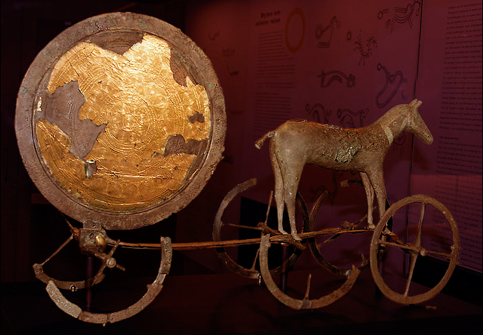
Sun Discs;
http://northstoke.blogspot.com/2008/02/lansdown-barrows-and-golden-disc.html
A few days ago someone who is writing a book on Lansdown race course asked me about the Bronze Age 'sun disc' that was found in one of the barrows. It was in fact gold over bronze (most of the gold having disappeared) and was in such a terrible state and in so many fragments that its reconstruction is a matter of drawing the complex pattern on paper, which both Rhiannon and Mike Aston have done.
Having delved through what little information there is, I was struck by the fact that the term 'sun disc' might be a misnomer for some of these artefacts. These Irish sun discs are buttonlike almost....
http://www.gutenberg.org/files/26880/26880-h/26880-h.htm#Page_62
There is a similar small gold disc found at Jug's Grave also,
http://www.themodernantiquarian.com/site/7660/jugs_grave.html
a few miles from the Lansdown, here we are in Wessex kingdom land of course, where gold is occasionally found in the B/A barrows. So was the 6 inch Lansdown a bigger version of a sun disc, and are the smaller ones more like ornamentation for horses or people, And not to forget the Trundholm Sun-Chariot a gold/bronze depiction of a mare pulling the sun, the disc has a certain similarity to the Lansdown one...
http://upload.wikimedia.org/wikipedia/commons/c/ca/Solvogn.jpg
|
This is a place I have never been to, and it looks like no one else has either. Its another Chevaux de Frise, though not the same as the 'Bryn Cader Faner' cairn which is so striking.
According to N.P.Figgis (Prehistoric Preseli) the method employed in building these treacherous out pointing stones might have been the result of an itinerant architect, be that as it may Castell Henllys, which is close to Carn Alw, has similar defence methods in its ditch, now covered by a later bank.
Carn Alw though situated at the back of Carn Meini if my map reading skills are right, is defended by "a wide chevaux de frise, incorporating set and naturally grounded stones in roughly three bands" on the easily accessible south-east side."
Figgis goes on to speculate as to whether the elaborate entrance and boulder lined lane with a kink in its length has something to do with a stock enclosure, either for bulls or ponies, as the area defended is very small. Wild ponies still graze these moors, and they are very like the small ponies depicted on Iron Age coins......
|
The question as to whether the burial cairns had been used for 'walker cairns', or other purposes remain unanswered. But the following information does state that one of the cairns was excavated in the 19th century. It is also interesting about the extensive settlement pattern below the summit cairns.....
"Carneddau Estate - Moel Faban,
prehistoric houses, paddocks and fields;
The rounded hump of Moel Faban ("moel" in Welsh means bare or bald hill in this context)
dominates the village of Bethesda and on both its east and west sides is extensive evidence of prehistoric settlement.
The east side was surveyed by RCAHM (Wales) for part one of the Caernarfonshire Inventory published in the 1950s but further evidence of prehistoric land use has become more apparent recently, and a new survey as part of a more long-term and comprehensive survey of the hill was commissioned.
The summit has a series of Bronze Age cairns, one of which was excavated in the nineteenth-century from which a collared urn of the middle Bronze Age was removed (now in the British Museum).There is no clear relationship at all but it is thought that some of the dwellings within the field-system could also have Bronze Age origins, but by analogy with similar sites they would normally be thought later. None has been excavated so this earlier date has by no means been confirmed. As well as concrete evidence of cultivation, or at least controlled pasturage, this immediate area has other tantalising evidence of prehistoric life.
This includes Bezant Lowe called the "arrow stone", a massive boulder on the top of which is extensive evidence of the sharpening of blades. There is to the east of the hill fairly conclusive evidence of burnt mounds situated by the stream of the Ffryddlas where food was cooked by dropping heated stones into small constructed pools, a technique that has been proved to work, as anyone watching "Time Team" will know!"
The 'Arrow Stone' on Rockartuk
http://rockartuk.fotopic.net/c1224904.html
References:
RCAHM(W) 1956 Carnarvonshire vol 1
Bezant Lowe,W. 1927 In the Heart of Northern Wales pp53 - 56
Griffiths,W.E.1959 Arch. Camb 101, pp44
http://www.nationaltrust.org.uk/main/w-ar4_s_wal.pdf
http://www.heneb.co.uk/arfonintro/arfonintroe.html
|
The plundering of megalithic tombs by vikings,
"Amlaibh, Imhar and Auisle (Audgisl) three chieftains of the gaill; and Lorcan, son of Cathal, King of Meath, plundered the land of Flann (North Brega).
The cave of Achadh-Aldai (Newgrange); the cave of Cnoghba (Knowth); the cave of the grave of Bodan over Dubadh (Dowth); and the cave of the wife of Gobhan at Drochat-atha (Drogheda) were broken and plundered by these same gaill."
Taken from the Annals of Ulster
The viking raids on the great megalithic tombs of the Boyne valley in 863; by Olaf (Amlaibh) Ivar (Imhar) and Audgisl, probably carried out because after all the monastic raids that had been undertaken over the previous years, 'treasure' was by now getting hard to find.
Is it true you may ask yourself, well it was recorded, and though there is some dispute about Newgrange (according to Gordon), it is a fascinating fact. The book I found this information from goes on to speculate, that one of the 'gaills' Ivar might have been the son of Ragnar Lothbrok, who spent three days in Maes Knowe because of a storm raging violently outside, and left the following scrawled on the wall...
This mound was raised before Ragnar Lothbrok's...
His sons were brave, smooth-hide men though they were...
It was long ago that a great treasure was hidden here...
Happy is he that might find the great treasure...
Be that as it may, I expect there was'nt much treasure in the great tombs of the Boyne valley either.
Information gleaned from 'The Fury of the Northmen' by John Marsden.
|
Although the Kenward stone is considered natural there is another story attributed to it that may give it a prehistoric link. John Chandler has written about it in this Wiltshire Council link....
http://www.wiltshire.gov.uk/community/getconcise.php?id=60
which states that the stone had been removed from a field in which other stones lay...
"about 1890, he reported, he had been told by two of Chute's oldest inhabitants that the stone had been moved there from a field where there were other big stones, some of which had been buried out of the way. But nobody by 1924 could remember where, and so part at least of the pseudo-Kenward stone's mystery remains."
|
This really is miscellaneous, but today someone sent me a photograph of a stone circle on the cliff top at Trefin Cove. It is probably a fairly modern one (though it looks real) but there is no literature for it. But some weeks ago, someone mentioned a circle in this area, so if you're on your way to Carreg Samson, stop off at Trefin Cove and look up to the cliffs, some information would be interesting as well.
a photo; http://www.geograph.org.uk/photo/1332814
|
Prehistoric artwork has been discovered by an amateur archaeologist at a Perthshire mountain range.
The ancient carvings were discovered by rock art enthusiast George Currie at Ben Lawers, near Loch Tay.
Mr Currie discovered a piece of rock which has more than 90 cup marks, which are circular depressions in the stone.
Some of the cups have rings around them and a number of linear grooves can also be seen, with some still showing the individual blows of craftsmens' tools.
Similar discoveries have been made in the area, but it is unusual to find so many markings on the one stone.
The purpose of the artworks are still unknown.
Derek Alexander, archaeologist for the National Trust for Scotland, said: "This is an exciting find as it shows that there remains undiscovered prehistoric rock art to be found in the Scottish hills.
"More surprising are the quantity and variety of the symbols displayed on this boulder.
"Through both targeted research by professional archaeologists and the work of dedicated amateurs like George Currie we now know that Ben Lawers forms one of the major concentrations of cup and ring marks in the Highlands, which suggests it was a very significant landscape in prehistory."
http://news.bbc.co.uk/1/hi/sco[...]ayside_and_central/8205035.stm
|
Well as people find it difficult to get to, some information from Jody Lewis's 'The Neolithic of Northern Somerset'
She says that when she surveyed it in 1998 that they found over 30 stones, some standing, some recumbent, the stone following the long axis e/w.
Stones remaining seem to be a section of passage at the east end, a chamber opening off and a chamber at the end, and that around the end chamber, are many stones that have the appearance of fallen capstones. It looks like she is saying that quarrying took place as well, and stones put back in are field clearance......
four chestnut trees on the mound and a lot scrub around, so unfriendly farmers, and large trees on top!
There is a whole cluster of longbarrows in this area, ruined by farming mostly...
Big Tree; Orchardleigh; Giants Grave; Barrow Hill; Fromefield, and slightly further afield Brays Down, and Stoney Littleton which of course is the best preserved of the whole group here.
|
Several years later and wandering through the Welsh saint book, and my stone just might be part of a stone circle and not disputed ;)...
The church was named after Rhian - 5th or 6th century, a follower of St.David. He founded a church here, "probably a wattle and daub building behind an earth wall" Breverton goes on to say.."In Llanrian parish, not far from Tregynon, is Llain y Sibedau (Place of Whispers) a ruined stone circle"
The Book of Welsh Saints.
1849 - Llanrian
"Near the church are some Druidical remains, consisting of many large stones, most of them now broken: they were formerly erect, and, in their arrangement and general appearance, formed in miniature, according to Mr. Fenton, a tolerably correct representation of Stonehenge".
From: 'Llanrhychwyn - Llansawel', A Topographical Dictionary of Wales (1849), pp. 85-98. URL: http://www.british-history.ac.uk/report.aspx?compid=47856
|
Showing 1-20 of 62 miscellaneous posts. Most recent first | Next 20 |
http://northstoke.blogspot.co.uk/
|
