Looking over the ringcairn and beyond, the high point in the distance is the modern cairn by Brown edge stone circle on Totley moor.
Image credit: megadread
Looking over the ringcairn and beyond, the high point in the distance is the modern cairn by Brown edge stone circle on Totley moor.

Looking west over the southern arc of the ring cairn

Looking west over the southern arc of the ring cairn

05/03. Southerly stretch of ring cairn.
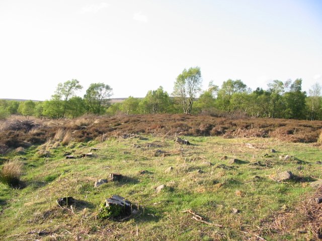
05/03. Bank can be less well defined in N & E.
Hmmmmmmmm, to visit in summer and see the site partially covered in bracken, which is now starting to encroach on it, or go in the winter for a clearer view and negotiate the very boggy terrain.
I chose the former for my first visit and it’s still quite tough going across this very uneven terrain.
My starting point was the access gate further up the road from the access point for Barbrooks 1 & 2, from there i took a bearing and headed off in as straight a line as i could, reaching the site in 10 – 15 minutes.
A bit of an anoraks site this one, there’s still a lot of it to see, though it is quite ruinous and a gps is advised, if you have one.
My gps recorded the site at SK 29025 75615
Not the easiest site to get to but I really liked this one. I parked at the same layby at SK281751 that gives access to Barbrook I and II, but took the track that leads east uphill to the ruined building of Ramsley Lodge. From here a decent track leads north then you need to cut across to the northeast towards the ring cairn. A word of warning though, parts of the moor are very marshy and I had to backtrack a couple of times to find a safer route. The site sits on a slightly raised area above this wet ground with views across it to the west towards Big Moor while just to the east the land slopes down to the stream that stands at the bottom of Hewetts Bank. The ring of rubble stones looked pretty well defined to my eyes, particularly to the south. On the way back I took a route towards the other entrance to the moor at SK283757 but this also proved quite waterlogged in places too.
As in Holy’s misc. post, the site has been sometimes referred to as a stone circle......I wonder if this is down to the 1:6250 O.S map where it’s marked as a “circle of stones”.
The cairn has recently been cleared of the Silver Birch that were growing on it’s banks. Apart from some compass work, the stacks of logs are among one of the few distinguishing things to look for when trying to find the ring cairn.
The rubble ring that is left is not very well defined but can be over 10ft wide in places.
Tick.
Seen it.
Shall I bother to return?
No.
From “Rock Around the Peak” by Victoria & Paul Morgan:
“… on the edge of Ramsley Moor, east of Barbrook I […] has sometimes been referred to as a stone circle, but is more likely to be a ringcairn. All that remains is a rubble bank circa 23m by 21m externally in diameter.”