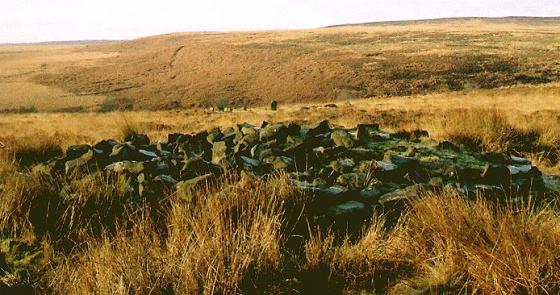
Unless you are walking Harland Edge then there’s not a lot to make you want to find this cairn. It’s roughly 5x4m in diameter and just visible above the scrub and heather.
From its position just below Harland Edge proper I would say it’s more than likely related to the settlement on Harewood Moor or perhaps one below the ‘edge’ itself rather than those on Beeley or Gibbet Moor.
Excellent views south over the remaining Eastern Moors to the White Peak in the south.
Sites within 20km of Harland Edge SW (b)
-
Harland Edge SW (a)
description 1 -

Harland Edge SE
photo 2description 1 -

Harland Edge cup marked rock
photo 3description 1 -

Harland Edge
photo 6description 4 -
Harland Edge Cairn
description 1 -
Fallinge Edge
description 1 -

Beeley Warren
photo 3description 2 -

Beeley Central
photo 4description 2 -

Beeley North (South 2)
photo 3description 4 -

Beeley South (South I)
photo 1description 2 -
Harewood Moor
description 1 -

Fallinge Edge
photo 1description 1 -

Hob Hurst’s House
photo 25description 13 -

Park Gate Stone Circle
photo 40description 7link 1 -

Bunkers Hill Plantation
photo 3description 2 -

Longside Moor
photo 1description 1 -

Beeley Moor
photo 6description 2 -

Beeley Warren ??
photo 2description 1 -
Beeley Warren NE
description 1 -

Beeley Warren NW
photo 1description 1 -

Gibbet Moor Standing Stones
photo 7description 2 -

Raven Tor Triple Cairn
photo 18forum 2description 9 -
Rod Knoll
-

Raven Tor
photo 2description 1 -

Holymoorside
photo 6description 2 -

Gibbet Moor South
photo 2description 2 -

Dalebrook
photo 3description 1 -

Gibbet Moor and East Moor
photo 9description 1 -

Bumper Castle
photo 1description 1 -
Gibbet Moor West
description 3 -

Gibbet Moor North
photo 19description 5 -

Gibbet Moor cist
photo 3description 2 -

Gibbet Alignment
photo 10description 3 -

Stone Low
photo 3 -

Gibbet Moor West
photo 1 -

Lindup Low
photo 1description 2 -

Newbridge Farm
photo 2description 1 -

Seven Brideron (site)
photo 1description 1link 1 -

Dobb Edge
photo 7description 3 -
Birchen Edge South
description 1 -

Chatsworth Park
photo 2description 1 -

Darley Dale
photo 5forum 2description 4 -

Gardom’s Ring Cairn
photo 8description 4 -

Farley Moor
photo 14ondemand_video 1forum 1description 8 -

The Three Men of Gardom’s
photo 11description 4 -

Gardom’s Enclosure
photo 17description 6 -

Gardom’s Pit Alignment
photo 3forum 1description 1 -

Gardom’s Edge
photo 22description 7link 2 -

Birchen Edge North
photo 1description 1 -

Gardom’s Edge II
photo 6description 2 -

Gardom’s Standing Stone
photo 20forum 1description 8 -

Calton Pastures
photo 11description 2 -

Handley Bottom
photo 1description 1 -

Cuckoo Stone
photo 4description 1 -

Stanton Moor North
photo 23description 5 -

Cat Stone
photo 3description 3 -

Tower Cairn
photo 7description 1 -

Nine Ladies of Stanton Moor
photo 97ondemand_video 1forum 26description 49link 1 -

Stump Cross Field Barrow
photo 3description 2 -

Eagle Stone
photo 9description 5 -

Stanton Moor Central
photo 20description 8 -

Ball Cross
photo 11description 2 -

Gorse Stone
photo 9description 4 -

T55 cairn
photo 5link 1 -

Ashover
photo 12description 6link 1 -

T25 cairn
photo 9 -

T44,45 & 46
photo 1description 1 -

Stanton Moor South
photo 17description 5 -

T2 cairn
photo 15 -

T37 cairn
photo 3 -

Swine Sty
photo 20description 3 -

Heart Stone
photo 2description 1 -

Cork Stone
photo 28description 7 -

The Andle Stone
photo 30description 11 -

Barbrook IV
photo 5description 5 -

Big Moor (south) cairns
photo 10 -

Barbrook V
photo 15description 3 -

Wishing Stone
photo 2description 2 -

Faybrick
photo 2description 3link 1 -

Turning Stone and Robin Hoods Mark
photo 8description 6 -

Barbrook Stone Row
photo 2forum 1 -
Barbrook I
photo 64forum 4description 15link 1 -

Doll Tor
photo 74forum 4description 15 -
Hole Stone (site)
description 1 -

Barbrook cairns
photo 34description 2 -

Doll Tor Standing Stone
photo 9description 1 -

Barbrook II
photo 47forum 1description 12 -

Haddon Fields North
photo 1description 1 -

Curbar Edge
photo 8description 1 -

Big Moor
photo 1description 1 -

Rowtor Rocks
photo 73ondemand_video 1forum 3description 11link 2 -
Haddon Fields South
description 1 -

Sanctuary Wood
photo 2description 1 -

Nine Stones Close cup marked stone
photo 6forum 1description 1 -

Nine Stones Close
photo 120forum 1description 20 -

Crackendale Pasture
photo 3description 2 -

Nine Stones Close standing stone
photo 8description 2 -

Cratcliff Rocks (Defended Settlements and Cave)
photo 27description 5 -

Castle Ring (Harthill)
photo 21description 2 -

Dudwood Tor
photo 3description 1 -

Barbrook III
photo 21description 9 -

Robin Hood’s Stride
photo 59forum 3description 15link 1 -

Harthill Moor Barrow
photo 1description 1 -
Blake Low
description 2 -

Dudwood
photo 3description 3 -

Bradley Tor
photo 7forum 1description 6 -
Grind Low
description 1 -

Bonsall Lane
photo 2description 1 -

Masson Hill
photo 3description 2 -
Burton Moor
description 2 -

Cranes Fort
photo 4description 1 -
Froggatt Edge cairn
-

Conksbury
photo 4forum 1description 1 -
Hirst Stones (site)
description 7 -

Stoke Flat
photo 42forum 1description 12link 1 -

White Edge Cairn
photo 1description 1 -

Bee Low
photo 1description 2 -

Brown Edge
photo 15forum 4description 5 -

Larks Low
photo 4description 1 -
Moisty Knowl (Site of)
description 1 -
Bole Hill
-

Calling Low Dale
photo 4description 1link 1 -

Longshaw Estate
photo 4description 2 -
Bole Hill Hillfort
description 2 -

Strawberry Lea
photo 11description 3 -

White Rake Long Barrow
photo 2description 1 -

Green Low
photo 22description 4 -

Green Low Barrow
photo 5description 2 -

White Cliff
photo 2description 1 -
Borther Low II
-
Castlegate Lane
description 3 -
Borther Low
description 1 -

Hob’s House
photo 6description 5 -
Hay Dale
description 2 -

Lawrence Field
photo 8forum 1description 3 -

Rolley Low
photo 1description 2 -

Eyam Moor III
photo 8description 4 -

Fin Cop
photo 19forum 1description 8link 3 -

Elton Common
photo 10description 2 -

Cales Dale Upper
photo 1description 1 -

One Ash Shelter
photo 2description 1 -

Eyam Moor II
photo 4description 4 -

Ciceley Low
photo 5description 2 -

Ringham Low
photo 2description 2 -

Middleton Moor
photo 1description 2 -
Hay Top
description 1 -

Kenslow Knoll
photo 7description 1 -
Long Gallery Plantation
description 1 -

Stoney Low
photo 3description 1 -
Moot Low
description 2 -

Eyam Moor Barrow
photo 24description 7 -

Fingerem Stone
photo 7forum 1description 4 -

Wet Withens
photo 32forum 1description 15link 1 -
Putwell Hill
description 2 -
Southwest of Burbage Bridge
-
Wardlow Hay Cop
description 1 -

Mother Cap Stone
photo 10description 2 -

Cup stone
photo 2description 1 -

Long Dale
photo 1description 2 -

Burbage Rocks
photo 1forum 1description 1 -
Ringham Low (Friden)
description 1 -

Toad’s Mouth
photo 2description 1 -

Stanage
photo 20description 6 -

Stanage II
photo 4description 2 -

Ravencliffe Cave
photo 4link 1 -

Gratton Moor
photo 2description 1 -
Slipper Low II
description 1 -

Smerrill Moor
photo 2description 1 -

Old Woman’s House
photo 1description 1 -

Hathersage Moor Ring Cairn
photo 2description 3 -

Toads Mouth Cairn /
Barrow photo 1description 1 -
Rockhurst
description 2 -
Slipper Low
description 2 -

Cales Farm SW
photo 2description 2 -

One Ash
photo 1description 1 -

Gotham Grange Barrow
photo 2description 1 -

Winyard’s Nick
photo 6 -

Gallows Knoll
photo 2description 1 -

Minninglow Round Barrow
photo 8description 1 -

Minninglow
photo 58description 12link 1 -

Carl Wark & Hathersage Moor
photo 65forum 2description 9link 1 -

Harboro’ Rocks
photo 27description 6 -
One Ash
description 1 -

Friden Hollow
photo 1description 1 -

Wirksworth II (site)
photo 2description 1 -

Wirksworth I
photo 12forum 1description 3 -

Ecclesall Woods 3
photo 1description 1 -
Tup Low
description 1 -

Galley Low
photo 5description 1 -

Wirksworth III
photo 1description 3 -

Gallows Low Lane
photo 2description 1 -

Peter’s Stone
photo 5description 2 -

Ivet Low
photo 1description 1 -

Arbor Low
photo 148forum 11description 41link 3 -

Round Low
photo 2description 2 -

Highlow Bank ring cairn
photo 1description 1 -
Roystone Grange
-

Powder Barrow
photo 2description 1 -

Rains Cave
photo 4description 2 -

Gib Hill
photo 31forum 1description 12 -

Gib Hill east
photo 7description 5 -

Highlow Bank Stone
photo 4forum 1description 2 -
Daisy Bank
description 1 -

Highlow Bank Cairn
photo 1description 1 -
Benty Grange
description 2 -

Aleck Low
photo 7description 2 -

Carsington Pasture’s Cave
photo 1description 1link 2 -

Offerton Moor East
photo 3description 1 -

Offerton Moor West
photo 6description 2 -

Roystone Rocks
photo 4description 1 -

Graves Park Round Barrow
photo 1description 1 -

Ox Stones
photo 14 -
Whirlow Hall Farm Henge
link 1 -

Ecclesall Woods
photo 17forum 1description 4link 3 -

Blackstones Low
photo 2description 2 -

Eaton Dale Wood
photo 3description 1 -

Smelting Hill & Abney Moor
photo 10description 2 -
Roystone Valley
-

Burr Tor
photo 3forum 1description 2 -

Rainster Rocks
photo 5description 1 -

Lime Kiln Barrow
photo 1description 1 -

Lean Low
photo 7description 3 -

End Low
photo 4description 2 -

Moneystone Barrows
photo 1description 2 -

Parsley Hay
photo 3description 1 -

Burton Bole
photo 3 -
Ows Low
description 1 -

Vincent Knoll
photo 1description 1 -
Hawks Low
-
Cop Low
description 1 -

The Stoup
photo 8description 4 -

Dennis Knoll & Sheepwash Bank
photo 1description 1 -

Carder Low
photo 1description 2 -

Hognaston Barrow
photo 1description 1 -

Bradbourne
photo 12description 3 -

Five Wells
photo 46description 13link 1 -

Tideslow
photo 12description 4 -

Liffs Low
photo 3description 1link 1 -

Chee Tor
photo 2description 1 -

Pilsbury
photo 5description 1 -

Bamford Moor South
photo 21description 8 -
Bank Top Oval Barrow
description 1 -
Bank Top
description 1 -

Cronkston Low
photo 6description 3 -
The Old Woman’s Stone
photo 4description 1 -

Chelmorton Low
photo 2description 1 -

Ash Cabin Rock Fall cave /
shelter photo 4description 1 -

Cross Low
photo 3description 1 -

Ash Cabin Flat
photo 16forum 3description 3 -

Ring Cairn/
Hut Circle photo 1 -

Ash Cabin Flat
photo 4description 2 -

Long Cist
photo 5description 1 -

Cist II
photo 1 -
Waggon Low
-

Ash Cabin Flat
photo 4description 3 -

Bamford Moor Central
photo 2description 2 -

The Lowe
photo 1 -
Nettly Knowe
description 1 -

Wolfscote Hill
photo 1description 1 -

Pillsbury Hills Castle
photo 2description 1 -
Crow Chin
description 1 -

Crow Chin North
photo 3description 2 -

Crow Chin South
photo 3description 2 -

Great Low
photo 3description 1 -
Stan Low (site)
description 1 -

Wigber Low
photo 17description 2 -

Frank I' Th' Rocks
photo 3description 2 -
Crake Low
description 1 -
New Inns
description 1 -

Bamford Moor North
photo 1description 2 -

Green Low Field Tumulus
photo 2description 1 -

The Holmes
photo 1description 1 -

New Hagg
photo 3description 1 -

Wind Low
photo 2description 1 -

Moscar Moor
photo 6description 2 -

Head Stone
photo 10forum 1description 2 -

Gratton Hill
photo 2 -

Fox Hole Cave
photo 23description 3link 2 -

Pin Dale
photo 1description 1 -
Gorsey Low
description 1 -

Moat Low
photo 2description 2 -
Cow Low
description 2 -
The Tong
description 2