View W from Titlington Pike.
Image credit: Rockandy
View W from Titlington Pike.

View W with the outcrop just to the left of the pond and Titlington Pike rising up behind the forests above the farm.

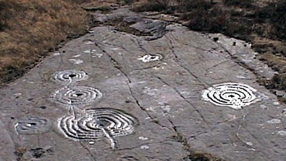
View W. Two parallel veins divide the rock into two parts. Cup and rings are on a horizontal part of the outcrop to the right of the prominent vein, adjacent to the centre turfed island. Other cups (some of which are probably artificial) are found between the two veins and to their left.

View from the outcrop S showing one of the millstone rough-outs.

View of the outcrop to the north over the shooting pond towards the forestry plantations of Beanley Moss.

Cup (and faint shadow of a ring?) on the SE edge.

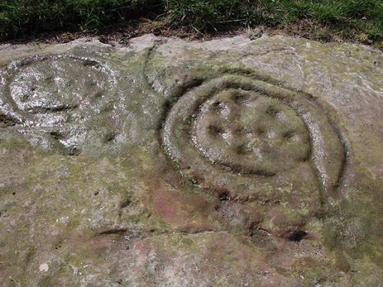
E’most cup and ring

W’most cup and ring

Two cups with highly eroded rings, a groove and other cups on the NE side of the outcrop.

1.5m diameter millstone rough-outs on the west side of the outcrop.
Friday proved to be a windy day up at Hunterheugh and the rock art team decided to try a bit of exploration. My main motivation for visiting this site above Titlington Mount farm was to compare the millstone extraction that we had been previously told about here with the two large carved rocks in the Hunterheugh settlement area. The locals refered to these as millstones too and that had never seemed particularly satisfactory.
Luckily, Dave T didn’t let me dismiss the cup marks on the E side of the same outcrop as natural erosion and showed that at least two of them have eroded rings. The simple nature of these motifs and the pattern of erosion makes them similar to those of Hunterheugh 4, nearly 2 km to the east. As well as the two cup and rings on the N side, there are other cups (which may be natural features) along a narrow area of rock bordered by raised veins, on the S side of the veins, and on the SE edge adjacent to thin turf cover. It is quite possible that some of these had also sported rings removed by erosion and now obscured by the lichen cover.
This find extends the rock art found in the Hunterheugh area west along the ridge which culminates at Titlington Pike (above Glanton) which sports two large overgrown Bronze Age cairns and provides fine views of the Cheviot Hills. The remains of a circular Iron Age fort is also present on the spur ridge just west of the farm.
Four ‘burnt mounds’, now covered by vegetation, lie on the banks of a small stream just below the cup-marked outcrop. Two of the mounds were excavated by Peter Topping in 1992-93. (Northern Archaeol, 15-16, 1998, 3–25). Both mounds contained hearths, troughs and other stone-built fixtures. Radiocarbon dating demonstrated that the sites had been in use in the Bronze Age over 3000 years ago. Pollen and other biological evidence showed a landscape changing from scrub woodland to moorland at this time along with some evidence of possible local cereal cultivation during the earlier phases of the mounds.
KTTP Entry for lost Bronze Age cairn
KTTP Entry for Titlington Settlement