Beckensall 6g. Close-up of multiple cups and the start of channels at the top part of the rock.
Image credit: Rockandy
Beckensall 6g. Close-up of multiple cups and the start of channels at the top part of the rock.

Beckensall 6g. Large sloping slab in an area near the junction of wall and fence that is a hot-spot for carved panels. Cups appear to be clustered around the heads of long channels.

Beckensall 6ac. A quarried slab with 4 cups, including one very large and deep.

Beckensall 6i. Close-up of basin at top of rock surface with cup and rings carved inside.

Beckensall 6i. View to N. A large sloping out-crop with 7 channels running down the surface. Some scattered cups and 3 cup and rings pecked inside one of the upper rough or natural basins.

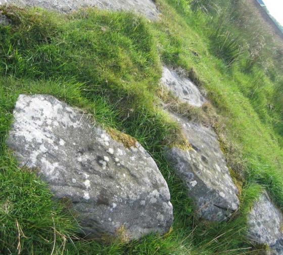
Beckensall 6k. A small boulder with 6 prominent cups.

Beckensall 6m. Close-up of highly eroded cup and possible ring.

Beckensall 6m

Beckensall 6m. Large basin and groove which may be a natural feature or added to. 3 cups nearby, two with faint eroded rings.

Beckensall 6p. An area of many rock slabs. This with 3 parallel grooves.

Beckensall 6o. View to NW.

Beckensall 6o. A large sloping outcrop with a long groove and 8 scattered cups.

Beckensall 6n

Beckensall 6n next to the earth wall, a 140x50cm boulder with 7 cups.
A search of Lordenshaw rock-art in the Beckensall Archive gives over 100 panels ranging from small boulders bearing single cup-marks to intricately carved outcrops and long grooved slabs. Best known are the main outcrop with an ancient Ministry of Works sign and the ‘Horseshoe Rock’ both west of the hillfort and easily accessed from the carpark at the east end of the Simonside Hills.
A large number of panels are situated east of the hill fort and continue north-easterly down the ridge to Whitton Dene above Rothbury. Some 30 panels north of the NZ/NU grid boundary make up the Beckensall 6 cluster designated as North Lordenshaw in the region of the standing stone. Convenient access is from the bridge over the Whitton Burn on the B6342, 1 mile south of Rothbury.
It is an area of boulders, quarried outcrops and large flat sandstone slabs. Many of the rocks have multiple cup-marks, some with faint rings. Large basins and long channels (possibly accentuated or eloborated natural features) are also a feature similar to those futher south. Views are predominantly to the north over Coquetdale and north-west to Cheviot with Simonside largely hidden behind the long ridge which rises toward the hill fort.