16-11-2008
www.briankerrphotography.co.uk
Image credit: Brian Kerr 2008
16-11-2008
www.briankerrphotography.co.uk

16-11-2008
www.briankerrphotography.co.uk

16-11-2008
www.briankerrphotography.co.uk

16-11-2008
www.briankerrphotography.co.uk

16-11-2008
www.briankerrphotography.co.uk

16-11-2008
www.briankerrphotography.co.uk

16-11-2008
www.briankerrphotography.co.uk

16-11-2008
www.briankerrphotography.co.uk

16-11-2008
www.briankerrphotography.co.uk


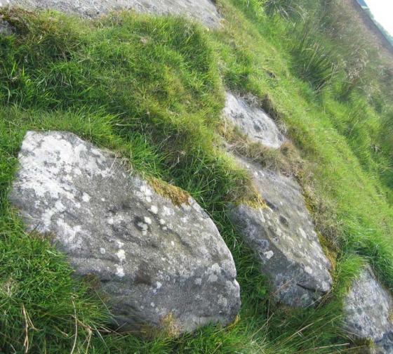
Hunterheugh 1; eroded motifs and enhanced basin with clear peck marks.

This set of C&Rs on panel 1 echo the arrangement of the motifs at Hunterheugh 4, or maybe it’s the other way round.

Hunterheugh 1; after the shower

A sort of serpentine thingy surrounding a cup. Most unusual, if not entirely unique.


What was under the cairn? This was. But now there’s no cairn.

Enhanced natural channel, with nice clear peck marks.

Very faint motifs brough out by side-spray of water and excessive post-processing of jpeg.

Hunterheugh 1. View SW from the outcrop towards the Settlement. Cup-marked rock and large quarried slabs visible in the foreground. Trees on the slopes of Titlington Pike are prominent in the distance.

Hunterheugh 1. Landscape view to the SSE of the excavated outcrop. The Bronze Age burial cist was located in a fissure created by movement of large quarried, cup-marked slabs in the centre of the outcrop. A dispersed cairn was removed during the excavation. Cup and ring motifs are visible on the nearer rock surfaces.

Hunterheugh 1. View SE from cup and ring marked outcrop. The sea is just visible in the far distance.

Hunterheugh 1. View form the outcrop S towards the Tittlington Burn and the hills of Jenny’s Lantern. The outcrop was carved, quarried, some surfaces adorned with newer carvings (including the double figure visible in the foreground) and surmounted by a cairn and burial cist during the Bronze Age. A natural rock basin contains water at the back. There is an extensive view from the site; from the hills to the W, to the valley of the Eglingham Burn (which joins the River Aln at Alnwick) and the coast to the E.

Hunterheugh 1. Cup and ring marked rock with strings of cups linked by grooves running down the rock surface, probably representing the early phase of rock carving at the site. This surface was illustrated by Stan Beckensall (2001) as Hunterheugh 1b. There is a cluster of cups on the higher (right) side. Linked cups run down the slope of the rock towards an heavily eroded cup with a faint double ring and a deep cup surrounded by a faint ring partly made up from an arc of small cups on its left-hand side. An arc of three cups runs towards the eroded motif from a higher boss of the rock surface, each cup getting shallower and equally spaced.

Hunterheugh 1. Small punch marks are found on parts of the same outcrop. Other groups of similar markings are also present. What is their significance and are they from the same period as the rock carvings or were they made in more recent times. The patterns don’t appear wholly random and look very fresh.

Hunterheugh 1. Heavily eroded cup and ring motifs from the earliest phase of rock carving, some of which was subject to later quarrying. Some of the quarried surfaces were adorned in a later phase of carving with new and more crudely-made motifs before being covered by a burial cairn dated to the Bronze Age.

Hunterheugh 1. N’most of the two motifs shown in a previous photograph and illustrated by Stan Beckensall as Hunterheugh 1d. The figure has two cups around which a freshly-pecked, shallow groove winds getting fainter to the W (right) side where it appears to end in a weakly-made rectangular shape. The motif was, before excavation, partially covered by a dispersed Bronze Age cairn.

Hunterheugh 1. Southerly of the two motifs shown in a previous photograph and illustrated by Stan Beckensall as Hunterheugh 1d.

Hunterheugh 1. Heavily eroded cup and ring motifs probably from the first phase of rock carving at this site. The figure on the left has a cup surrounded by two closed, pennanular rings; that on the right has a faint, pecked groove running down the rock surface. Other, eroded cup and rings can be seen above. A similar photograph appears in the British Archaeology article linked from the Beckensall Archive site.

Hunterheugh 1. Two large motifs delicately picked on a previously quarried rock surface and partially covered by the Bronze Age cairn removed during excavation. Both motifs are arranged in the same direction showing some similarities but also clear differences in design. That on the left (N’most) is much finer with a faint serpentine groove showing many individual pick marks and apparently incomplete. A prsistine but weakly made cup and ring can be seen above the left hand figure and more heavily eroded (?older) motifs on the rock surface below.

Hunterheugh 1. A deeply hacked cup and ring motif uncovered by excavation in 2004. It is interpreted as being from the second phase of rock carvings on the outcrop, made on a previously quarried surface where older carvings may have been removed. Pick marks are clearly visible in the deep cup, inner and partial-outer rings.

Very nice rock art site.
The photos here by Jan and Gus show what it looked like before the excavation. It looks a bit different now, the cairn isn’t there at all. Instead, there are a couple of motifs that were previously overlaid by the cairn. The results of the excavation concluded that the outcrop had been marked, then some of the carvings had been quarried, then re-marked, but in a way that implied a lack of understanding of the original motifs, and in a much cruder manner. Now I think this might be being a bit harsh on the Bronze agers who made the cairn. The crudeness of execution could possibly be that their motifs haven’t eroded quite as much, and just because they are not placed in a manner that allows the running of water from one to the other, doesn’t make them cruder as such. Whilst they may have not known the meaning of the original markings, it’s got to be highly probable that their own symbols, which are more complex, had meanings of their own.
It’s a great place to check out fresh peck marking. The two most complex designs are so clear you can count the individual pecks, they’re quite shallow and form unique designs, with closed penannulars and a strange keyhole shaped thing with a serpentine tail. There’s also an excellent example of what are referred to as enhanced channels. This is one of the ones that would have been covered by the cairn.
I’d definitely recommend visiting in dry weather when the bracken is low, as there are bogs and the bracken tops 6 feet in places. The ground is very uneven too, so it’s quite easy to trip over boulders, or have a foot or even a whole leg disappear into a crevice. There’s a IA settlement to the west and some BA cairns just to the east, but these are invisible in the high bracken of summer.
I didn’t have time to look for the other panels, but the main one was enough to make me quite content. There are enough motifs, some clear, others really faint, that I found an hour not long enough to appreciate the place properly.
Hunterheugh on BRAC Updated
Provides a readable interpretation of the sequence of rock carving on the outcrop arising from an excavation by Clive Waddington in 2004.
Rock surfaces carved in the early Neolithic (Phase 1) were later partially quarried and new symbols applied to the exposed surfaces. The Phase 2 carvings are more varied but more crudely executed and take less account of the rock surface. Shortly after they were made, it is likely that they were covered by a cairn incorporating an Early Bronze Age burial cist positioned in a cleft between massive slabs of quarried rock, some with the ancient cup and ring markings. At a much later stage, the outcrop and cairn was embedded into field boundaries of the Iron Age or Romano-British period which may have been partly protective from more extensive quarrying.
The changes in carving between the two phases may imply that the original significance had been lost by the Bronze Age but the power of an already ancient place was adopted to provide a ceremonial monument for the dead.