
Foel Offrwn (centre) and Foel Faner (to right): two hillforts standing before the great escarpment of Cadair Idris. Yet more loom beyond overlooking the Afon Mawddach. Viewpoint is near Moel Cors-y-garnedd, above Bwlch Goriwared.
The prominent Foel Offrwm from the neighbouring hillfort on Foel Faner, across Llyn Cwnwych.
Foel Offrwm is centre of shot, with Y Arannau behind. Lower down to the right is Foel Faner. Seen on the descent from Y Garn, above Ty’n-y-Llwyn.
Foel Offrwm is the prominent hill in the middle distance, just left of centre. The skyline mountains behind are the Arannau, with the Dyfi Hills over to the far right. The viewpoint is the New Precipice Walk below Foel Ispri.
The excellent hill fort seen descending the wondrous Y Garn to Cwm Yr Wnin late in the day, Y Rhinogydd.
The lower settlement is aptly named. Not to mention exquisitely sited.
Looking across to Y Rhinogydd... not particularly high, but possessing some of the roughest ground in all Wales.
The Arans suddenly lose their clammy mantle...
Toward Aber Mawddach.
Looking north(ish) to Central Snowdonia.
Cadair Idris stands above Dolgellau to the left, sweeping down toward Aber Mawddach.
Foel Offrwm in fading light, seen from Dolgellau golf course. The lower enclosure is the sticky-outy bit.
Rubbish light for capturing hill fort defences, perhaps... but sublime light for chasing windmills. Cadair Idris displays its northern escarpment.
Wales’ green hillsides present the broadest canvas for Nature’s impromptu, all too fleeting brush strokes.
The inturned entrance almost resembles the footings of a gatehouse...
Unlike Aran Fawddwy, Rhobell Fawr doesn’t possess a prehistoric cairn, as far as my memory serves. But it nevertheless adds to the wonderful vista from Foel Offrwm.
An annoying cuboid block of a cairn crowns the site... what is that all about? Great drystone ramparts, though.
Looking from Foel Cynwch...
Less impressive fortifications on the western side due to the steepness of the hill.
Round house platform on the western edge of the fort/enclosure.
Standing atop the eastern part of the entrance.
Looking north over the fallen walls.
Looking south over the either ancient or recent structures.
Standing amid the destroyed walls looking south-ish.
Ancient structures or recent sheep folds ???
Far off hill could be Rhobell Fawr north east of Moel Offrwm
Two lines of tumbled walls, the far off one is modern.
Looking through the impressive entrance to some distant hills and mountains the names of which I know not.
Standing in the entrance looking east-ish.
Standing in the entrance looking west-ish
Rising above it all, boy it was windy though.
The impressive double entrance type thing, and the modern cairn utilizing stone from the walls. Booo!
Looking up at the tumbled walls of the larger and higher of Moel Offrwms enclosures.
The smaller lower enclosure, time had just about run out, so a zoomed pic will do for this visit.
The smaller lower enclosure caught in a gorgeous sunset, clouds billow over Cader Idris and the Mawddach estuary on the right.
The smaller lower enclosure caught in a gorgeous sunset.
The smaller lower enclosure caught in a gorgeous sunset, as clouds pour over Cader Idris.
There was clearly a lot of Iron Age activity in the hills north of what is now Dolgellau during the Iron Age.......... the two enclosures upon Foel Offrwm obviously not lacking in neighbours. The viewpoint is Mynydd Moel, eastern of Cadair Idris’s main triumvirate, also bearing a probable ancient cairn. The positions indicated are, of course, approximate (give me a break, my eye sight’s not that good!)
Now I’ve often stood upon the shattered dry stone ramparts of upland hill forts and wondered whether their original inhabitants might have similarly enjoyed the natural aesthetics of their home, albeit an appreciation infused with inherent spiritual connotations now lost to us? Or did familiarity breed contempt, as perhaps suggested by conversations with a number of farmers down the years? Rhetorical questions, I guess. Whatever the truth of the matter, there can be little doubt that the numerous Iron Age settlements located in the outlying hills of Cadair Idris, overlooking the beautiful Afon Mawddach, occupy sublime locations indeed. Foel Faner and Foel Offrwm, rising to the approx north of Dolgellau, are cases in point...
My intention was actually to re-visit Foel Faner (a return’s been on the list for years); however, I encounter a huge outing of schoolchildren apparently en-route to the ‘Precipice Walk’ (their teachers seemingly in dire need of some of the local collies to help keep the little horrors in check) and recall Foel Offrwm is not exactly lacking in prehistory. Hey, why not do both? Why not indeed, assuming the legs – and everything else – oblige me. The aforementioned ‘Precipice Walk’ (incidentally well worth undertaking when visiting Foel Faner) is served by a large, free car park featuring public toilets for your convenience, signposted from the eastern environs of Dolgellau. From here follow the road toward Llanfachreth for a short distance before veering right upon a well made track beside a well built dry stone wall. The wall soon cedes to open hillside towering above..... a very steep hillside. This is Foel Offrwm, the main hill fort site crowning the top as you might expect. To be honest ‘very steep’ might well be a bit of an understatement! Nevertheless I’d suggest the prize is well worth the considerable effort it demands from me. Excellent retrospective views toward the craggy summits of Y Rhinogydd bolster flagging resolve as I gain height until the initial tell tale masonry courses signify an end to the ordeal. Not before time.
The defences are much more significant than I (for some reason or other) had supposed, the main dry stone rampart supplemented to the south/south-east(ish) by an additional line covering the less extreme landscape topography there.... clearly the presumed focus of any assault. The entrance is a nicely ‘in-turned’ example facing east, no doubt so placed to prolong the exposure of an attacking force to defensive missiles. So it would appear this was a serious, top-of-the-line upland fort back in the day, constructed by people who very much knew what they were doing. However there is one feature I can’t make head nor tail of.... a large, solid cuboid block of dry stone masonry at the summit of the enclosure. Yeah, what is that all about? I assume it dates from relatively recent times, but was there once a Bronze Age cairn here? I’d like to think so.
Substantial defences notwithstanding, the location of this hill fort is surely its primary attribute, offering outstanding vistas in all directions, albeit views aided by the sun breaking through the morning’s overcast sky. Always a good thing. The pick is probably looking south-west toward Cadair Idris and Abermawddach, although Y Rhinogydd are ruggedly splendid to the west, The Arans rear up to the east, to the left of the aptly named Bwlch Oerddrws (Pass of the Cold Doors).... and northern Snowdonia completes the picture. Oh, and Rhobell Fawr certainly looks its best from here. I gaze across the valley to Foel Faner and debate with myself (a sure sign of madness) whether I’ve the time to visit Foel Offrwm’s ‘lower settlement’ just visible to the south. Dunno... probably not much good. Wrong!
Sometimes some places take you by surprise, this one did it to me, I know the local terrain, I knew where would be visible from up the top, but I didn’t know what to expect from the remains of these two hill top enclosures, and the weather had been mostly grey with hints of changeability.
The kids elected to stay in the car, whilst stone mad dad went for one last walk. Less than a mile from car park to fort to the other fort and back, shouldn’t take long. Eric took one look at the steep sided hill and shook his head sternly, “your on your own this time Dad”
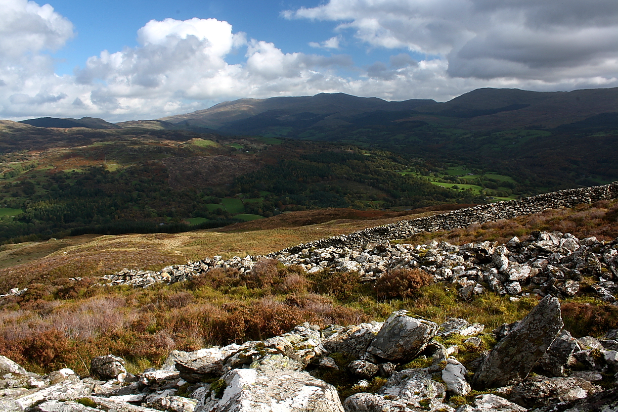
So off I went, for most of the upward yomp the car park was in full view, I neglected to put back on my walking boots and the hillside turned out to be a bit slippy in my work trainers. As height is gained the views west and north open out, Rhobell Fawr is dominating the north and far to the north west The Rhinogs begin to peep over the nearer hills. Still higher still and Cader Idris is very prominent to the south south west with huge clouds billowing down over the high ridge. Then to the south west the Mawdadach estuary can be seen happily taking away as much water off the hills as it can carry. Then sweating and breathing hard the top has been attained, before I reach the nearest stretch of tumbled walls I notice there is a lot of pure white quartz scattered all over the hill top, pretty.
Standing upon the spread of wall material on its north western side I note that with my usual alacrity I have climbed the hill via it’s steepest way, there is a footpath edging round its northern way but it’s the very long way, my way though very steep was most direct. I begin the circumambulation of the fort, or is it an enclosure, i’d rather the fort label as a pig pen can be described as an enclosure and this is so much more. At its steepest point the walls have disappeared altogether, but soon the hill is more gentle and the scattered rubble gets higher and wider. Then it gets much more complicated as the walls are so substantial that interior walls can be seen, whether these are truly ancient or more recent I cant tell. From there I make my way to the top, where a tall square cairn has been erected, from the fort walls, pah, and booo!!
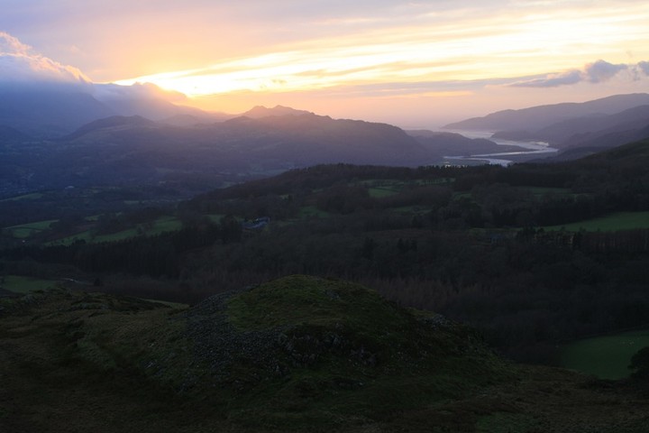
Just yards away is the entrance, it is a complicated affair, the inner wall turns outwards at 90 degrees then back on itself at 90 degrees to form a double wall. But these were not the surprises that took my breath away great as they were, the sun I thought had already gone down, but I was mistaken, it still had some way to go before it dipped behind the lower hills below Cader Idris, just south of Pared y Cefn hir. A massive golden glow burst through the clouds and I stood rooted to the spot for how long I don’t know, then I remembered my camera and set about trying to record the moment, for these do not come along often, my camera is mostly obstinate at capturing light and dark at the same time but it seemed to be coping well.
I ran about on the hill top trying to get all the best bits in the best light ive seen in along time, mostly the entrance, then I recalled the other lesser enclosure and realised it would be directly between me and the sun, I jogged off down the hill, trainers giving up all hope of being dry. There it is, damn, I thought, I’m not going to have time to get a good look at that one too, so I made do with a selection of photos on my way past, down and on my way back to the car. Getting down was harder than coming up, more slippy, legs more wobbly, the precipice walk is near here , but not here, but it should be. Eventually I got back to the car, to hoots of derision as to how long it took, ah well you cant have it all, but we’ll always have that sunset.
There are two walled enclosures on the summits of Moel Offrwm, and the traces of many small round structures (surely roundhouses, though Coflein does not commit the site to any particular period).
It’s not connected with the forts*, but is a very local story: There was an oak just beneath the mountain on the west side, known as Derwen Ceubren yr Ellyll, ‘the goblin’s hollow tree’. It must have been quite crowded in there as it was also supposed to have been haunted by a compatriot of Owain Glyndwr, Howel Sele. The two men had been enemies but had allegedly made up, and were hunting deer together. Sele took a crafty shot at Glyndwr, but was rather surprised when his arrow bounced off the armour he was cunningly wearing underneath his vest. Gyndwr was understandably angry. Years later a skeleton ‘resembling Howel Sele in stature’ was discovered in the hollow tree. The tree met a natural fate in the early 1800s.
From: ‘Llanvachreth – Llanvagdalen’, A Topographical Dictionary of Wales (1849), pp. 111-15.
british-history.ac.uk/report.asp?compid=47858
*unless you’d like to think that Sele had his stronghold in one of the forts.