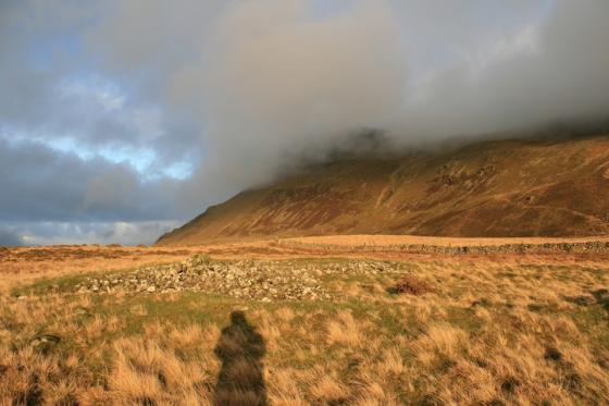
The forbidding cliffs of Mynydd Moel, seen from the ridge to the east.
Image credit: A. Brookes (13.5.2023)
The forbidding cliffs of Mynydd Moel, seen from the ridge to the east.

The clifftop perch of the cairn. Yr Wyddfa distant skyline.


There is a serious volume of stone here. Looking towards the Tarrenau.

The wrecked cairn, shelter on the left and marker cairn on the right, both formed from the stones of the original monument.

The southwestern arc of the footprint, looking towards Pen y Gadair, the summit of Cader Idris.
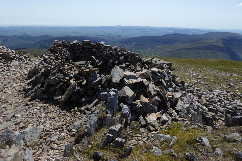
The shelter built from the wreck of the cairn. Pumlumon (I think) on the distant skyline.

Mynydd Moel from the cliffs to the west. The summit is marked by a rocky outcrop with a cairn on it (top right), but as a result the Bronze Age cairn is out of sight from this angle, interestingly.

Mynydd Moel is the left-hand of the three central peaks of Cader Idris. Seen from Craig y Castell to the north.

Mynydd Moel is the lefthand of the three summit making up the central mass of Cader Idris. Seen across the Mawddach estuary from the south ridge of Mynydd Egryn at the tip of Y Rhinogydd.

Mynydd Moel is the left hand of the three central summits of Cader Idris. Seen from Y Garn (Rhinogydd), across the other side of the Afon Mawddach.

Y Brenin Llwyd is in residence today. From Mynydd Ceiswyn to the east.

Looking west from a swelteringly hot Mynydd Moel...

Looking across the Afon Mawddach from Mynydd Moel toward Y Rhinogydd...

Looking east along the great northern escarpment of Cadair Idris. Granted, there is an excellent ascent available for stoneheads from Bwlch Llyn Bach via Gau Craig which is (arguably) a little easier...

Mynydd Moel on the left, from Cyfrwy further west on the Cadair Idris ridge. The large summit cairn, now hollowed out to form a shelter, is behind the prominent outcrop visible from here.

Cadair Idris from the summit of Tarren y Gesail to the south, across the Dysynni valley. Mynydd Moel is the peak on the right of the central bulk of the mountain. Far right is Gau Graig, the most north-easterly peak of the Cadair Idris massif, crowned with a probable prehistoric enclosure. The summit of Arenig Fawr can be seen over the top of the ridge between the two. The distant peak far right is, I think, Rhobell Fawr.
Mynydd Moel (2,804ft / 863m) is the eastern of the central summits of Cadair Idris, that wondrous mountain ridge rising more or less straight from the sea south of the beautiful Mawddach Estuary. Numerous lakes flank the massif at varying altitudes... creating, it may well be argued, an ideal landscape context for the siting of Bronze Age funerary cairns. Hence I’ve alway been a bit perplexed that none of the cairns crowning the main Cadair Idris peaks have been historically assigned an ancient origin (as opposed to the lower summits further to the west). Having said that the mountain is very popular with walkers, the cairns badly damaged. Unfortunately such judgements tend to be taken at face value... when what is required are inquiring minds driven by the evidence on the ground! (he says, hanging a guilty head in shame). But what views regardless!
It was therefore with considerable interest that I happened to browse Gwynedd Archaeological Trust (GAT) records and note the following, particularly the reference to ‘an arc of kerb to SW’ (PRN 4768):
‘A cairn stands on Mynydd Moel, 10m to the SE of the highest point at 855m on the edge of steep crags. It comprises ‘a low spread of stone, 15m diameter, heavily rebuilt to give a rectangular shelter, but with an arc of kerb on the SW and a stretch of 1m high facing formed by large stones set as headers filling a shallow gully to the NE’. [Sources: Crew, P. , 1980 , Archaeology in Wales; Smith, G. , 2001 , Prehistoric Funerary and Ritual Sites Survey: Meirionnydd].
Looks like TMA needs some close-ups for confirmation, then.....