
the rockshelter from the west.
Image credit: IH
the rockshelter from the west.

Basin on the roof.

Basin on the roof of the shelter. View to the north with Cheviot on the horizon.

The floor of the shelter.

Small standing stone just north of the shelter. Cheviot on the horizon.

Rock shelter from SE.

Rock shelter from SE, view towards Cheviot.

Motif carved on top of the dome of rock above the shelter. A large basin surrounded by a shallow groove has a long groove running south down the sloping rock surface.

Interior of rock shelter from open end. Groove pecked on floor starts at the shallow basin near to the marker.

Shallow basin and groove that follows a vein in the rock and runs down the floor of the shelter to part where Stan Beckensall excavated a cremation burial in a food vessel of c.2000 BC. Stan describes the groove as having been pecked with a hard stone tool. The basin has been roughened possibly to hold a wooden upright (other metal-cut post holes are present) and the gutter may have been originally cut as a drainage channel.

Standing stone below rock shelter; view NW towards Cheviot.

Enhanced basin surrounded by groove with a long groove running down the rock above rock shelter; view W to Edlingham old railway viaduct, village and Thrunton Wood.

Above the shelter; artificially-enhanced basin and groove.

Floor and rear wall of rock shelter. Basin in floor starts a shallow groove which runs along the vein of rock down to a lower level where a burial was found covered by a triangular rock slab.

View of Cheviot (with small rim of snow) from the rock shelter.

Close up of the inside of the rock shelter.
Note the carved “arm chair”-a later addition.
Stan Beckensal, who excavated the floor of the shelter in 1975, found a mixture of artifacts dating from about 8,000 years ago (Mesolithic flint flakes) and a cremation urn from 4,000 years ago, which was covered by a triangular, cup marked stone. A similar motif can be seen on the top of the shelter. (Stan Beckensall--“The Power of Place” 2001 Tempus Publishing Ltd)

Large basin and grooves (probably formed by natural erosion) on the roof of the shelter. View NW over Iron Age settlement, below in trees, towards Wooler and The Cheviots.

View of the rock shelter from one of the standing stones on the slope below.

The rock shelter from the S.
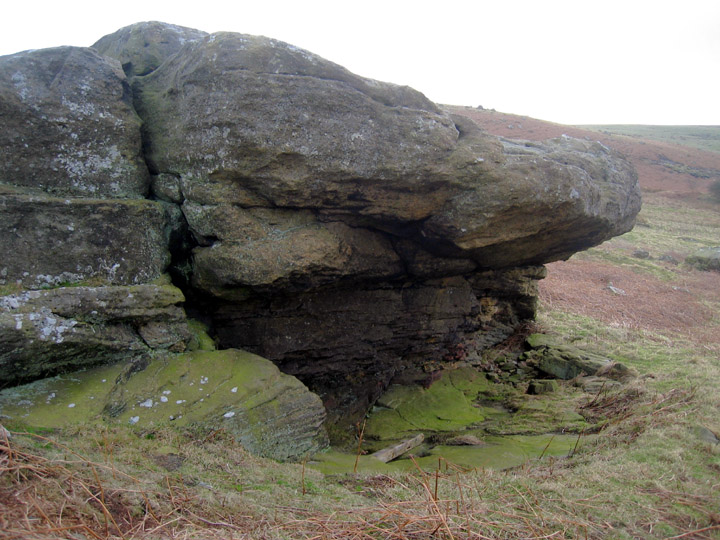
The rock shelter from the NW.
The last time I visited here, it was a very short visit, as it’s tantalisingly close to a very picturesque parking spot on the road from Alnwick to Edlingham, and the short hop up to the outcrop only takes a minute or two, up the trackway past the remains of bell pits. It’s not the best track in the world, a pushbike could make it, or a 3-wheeled buggy, but not a wheelchair. The incline isn’t steep, but there is a need for hitching through or over a low wire fence, as the gate between the track and the outcrop seemed to be fixed shut.
The rock art is rather sub-standard, but the rock shelter and the outcrop itself are quite nice. The position in the landscape is unarguably the best aspect of the site. The view is very good.
I’m not sure what to make of the line pecked into the floor of the shelter. It’s definitely pecked out, and looks very much like the kind of thing you’d see emerging from a cup and ring. Stan Beckensall has it as emerging from a ‘shallow basin’. I’m not 100% with the basin idea. The presence of iron tool marks in the basin, combined with the fact that it’s not convex, and is on a slope would make it a poor basin. It’d not hold water. There is a chance that the basin like area is the remains of a patch where the original surface has been removed. This raises the possibility that there was once a more cup and ring like motif here, removed in later years by whoever carved the rudimentary chair and the post slots under the overhang.
Between the shelter and the lovely view of Cheviot, is the standing stone. At first glance, I was a bit dismissive, as it’s not overlarge, and there are larger boulderrs nearby that are just as upright. But closer inspection shows that it’s out of place, and has a much higher than usual amount of quartz in it, making it look to me as it it could have been chosen as a suitably snazzy stone, then lugged here to mark the site as somewhere special.
The thing on the top of the outcrop does look like rock art, being one of those ‘enhanced natural features’ that can be so perplexing. But it must be an artificial groove around the basin. I did wonder why this basin was chosen for enhancement, when there are a couple of others that look like they’d do the job (whatever that is...) just as well. Maybe it’s because of the direction of the natural groove, pointing down into the valley below. This valley looks intriguing. It’s a bit reminiscent of the rockforms at Ketley Crag, full of jaggedy anthropomorphic outcrops, festooned with tumbled boulders, with many nooks and crannies that could easily be gateways to the underworld.
From KeysToThePast site number N4227:
A natural rock outcrop overlies a rock shelter that contains evidence of prehistoric activity. An excavation there in 1975 discovered Mesolithic flints and an Early Bronze Age cremation in a pottery vessel. In addition the upper surface of the shelter is decorated with a carved basin and a groove, markings that are probably associated with nearby cup and ring marked stones. The shelter also seems to have been used in more recent times as post-medieval clay pipes, glass, pieces of iron and ledges carved in the rock were also found.
A good place to sit out of the wind with good views and the skylarks learning again how to sing as they think the winter may be over. Now, where did I drop my clay pipe?
I imagine the Corby of the name is really a ‘Corbie’? – that is, as the OED says, a raven (or maybe a carrion crow).
That’s a nice image – the Corbies’ Crags.
But they’re not always ‘nice’ of course, as in this traditional Scottish ballad, The Twa Corbies, in which they daydream about picking out and eating the eyes of a dead knight:
books.google.co.uk/books?id=_g4JAAAAQAAJ&pg=RA1-PA283&lpg=RA1-PA283
Careful on those crags then.


