
structural remains
Image credit: wideford
structural remains

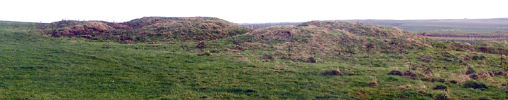
view from right near 35 degrees E of N fence, s’ern end at left

exposed side of mound showing stones and ?black earth layer

The weather was still against me so I settled for a ‘drive by’ look.
From the A961 to the south I could see two grass covered mounds.
A visit on a dry day would be in order.
The site can be approached by the track to the right of Fernbank on the road to Holm. On my second visit I saw that the barred wooden gate merely lay across the fence, ingress lies by a middling height ‘Orkney gate’. They’re making these things taller and tighter but I got by just moving the top a little. Didn’t want to lay the thing down in case it became tangled – if you do the same take into account the barbwire around the fencepost (I wondered what the scratching noise was !). The closest I could approach from this field was the mounds’ field boundary, there will be a way in but it looks as if that would involve a lot of ‘going around the houses’ as I can see no convenient trackway (from the main road leastways).
I was intrigued by the amount of stone protruding from the ground in various alignments as I traversed the wide trackway. Fortunately the site is very close to the fieldfence. This runs at 35 degrees west of north. From here the view runs from mound 5 in the RCAHM’s 1946 inventory at the extreme left to the barely perceptible mound 3 at the right. The individual item that first strikes one is where a large area of stones is exposed. Nearer to there is a layer of what appears to be dark earth above the stones. But though the site in general bears a resemblance to the Grimsquoy mound/s near the airport by the Sands of Wideford, which has been call a burnt mound, it is too great a distance from the Rashieburn itself to be one. However of more obvious importance is something that the last archaeological report did not mention so must have been exposed since then. In a mound to the left of the one just mentioned is a very short length of drystane-walling two stones long and four or so courses high. A few metres to the right, apparently in another mound from my limited perspective, there is another stone at the level of the upper course. Perhaps a continuation. As with Grimsquoy one has to wonder what the number of mounds was originally, have there been additions to a lesser number or a sub-division of such?
To some early antiquarians The Five Hillocks (according to RCAHMS NMRS record no. HY40NE 4 the five in the NW corner of the site at HY45980536) were the Circle of Loda mentioned in the now largely discredited poems of Ossian. But archaeological survey found a kidney-shaped site of eight mounds, one lobe smaller than the other where there was report of a break in the surrounding bank. All have been excavated at some time unknown. In one the depression extends down to the base and exposes a small edge-set earthfast slab that could represent a cist. Since the first report one barrow has been lost, and at the time of the second report the southernmost was going the same way. The bank is spread low about 10’ across, the mounds are up to 7’ high and 15-40’ across.


