exterior view of stonework
Images
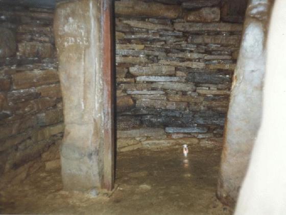
The lower chamber.
Back of lower chamber.
A curious looking stone from chamber.
Articles
Crossing the coastal fields to Castle Howe the vegetation was tall and rank, making this is the worst time of the year to investigate such a ruinous or fragmentary site. I never learn. Couldn't really tell what was underfoot, seemed to be channels and/or ruts of some type as I neared the hill. Coming up my feet encountered a multitude of lumps and bumps and I appeared to be climbing over different levels on the hill, putting me strangely in mind of Wideford Hill Cairn. What a struggle to reach the top it had been. Be very careful going about the summit still. Once there I found it took a while to tell the chamber wall from the outer protection of the excavator's wall. Rather disappointing. The inner area looked like a rockfall and I wasn't aware of seeing any steps at the time. Mindst you the modern wall isn't weathering well either. Just about worth it still.
A report made following a 1933 visit to Castle Howe (contained in the National Monument Record) indicates that part of Castle Howe may be prehistoric:
The lower chamber appears to be prehistoric, its walls survive to a height of 5ft. 3 ins; the stairs may be original..."A similar report following a visit to the site in 1964 makes no attempt to date the site. There is no certainty as to the age of this monument, but the NMR implies that part of it may date back to the Iron Age.
RCAHMS NMRS No. HY50SW 13 though it occupies a typical broch site shows no evidence of circularity and so is classified as a promontory fort. A member of the clergy excavated a 'domestic structure' on the top from 1929-31 and then built a 1m high square wall about it afterwards. There were two structures above one another, of which only the lower was certainly prehistoric. This lower chamber was D-shaped with a floor 2.6m below ground level (reached by steps) and walls 2m high. Its entrance and that of the modern protective wall are held in common at the west.
Sites within 20km of Castle Howe
-
St. Nicholas Church
description 1 -
North Howe
photo 9 description 2 -
South Howe
photo 17 description 1 -
Tower of Clett
photo 3 description 5 -
Lamb Holm
photo 10 description 4 -
The Cairn
photo 3 description 2 -
Stembister
photo 9 description 3 -
Hall of Gorn
photo 3 description 3 -
Laughton’s Knowe
photo 4 description 2 -
Venikelday
photo 7 description 4 -
Southtown (Burray), St Lawrence Church
photo 9 description 4 -
St. Mary’s Broch
photo 6 description 2 -
Dingieshowe
photo 5 description 5 -
Comely
photo 3 description 1 -
St Peter’s Kirk
photo 4 forum 1 description 3 -
St. Peter’s Bay
photo 9 description 2 -
Burn of Langskaill
photo 2 description 1 -
Round Howe
photo 8 description 4 -
Long Howe
photo 8 description 7 -
Mine Howe
photo 27 forum 2 description 18 link 6 -
Mussaquoy
photo 9 description 5 -
Hawell
photo 4 description 3 -
Mecigar
photo 2 description 2 -
Nearhouse
photo 3 description 1 -
The Five Hillocks
photo 6 description 3 -
Eves Howe
photo 5 description 2 -
Hurnip’s Point
photo 6 description 3 -
Craw Howe
photo 1 description 4 -
Newark
photo 3 description 3 link 1 -
Ston Loe
photo 1 description 2 -
Staneloof
photo 3 description 1 -
The Five Hillocks
photo 5 description 3 -
Howe of Staneloof
description 1 -
Backland
photo 4 description 2 -
Howan Blo
photo 2 description 2 -
Whitecleat
photo 4 description 2 -
Millfield
photo 3 description 2 -
The Howie of The Manse
photo 3 description 2 -
The Cairnhead, Hunda
photo 4 description 1 -
Loch of Tankerness
photo 13 description 4 -
Kirk Ness
description 1 -
Kirk Ness Mound
photo 2 description 2 -
Yinstay
description 1 -
Kirk Ness Dyke
photo 1 description 1 -
Sorquoy
photo 11 forum 1 description 5 -
The Brough
photo 1 description 2 -
Kirkhouse Cairn
photo 2 description 2 -
Berstane Broch
photo 9 description 1 -
The Wart
photo 11 forum 1 description 4 -
Riggan of Kami
photo 12 description 2 -
Hillhead Enclosure
photo 16 description 5 -
Hillhead Well
photo 4 -
Howe of Hoxa
photo 16 description 3 -
Little Howe of Hoxa
photo 18 description 2 -
Scapa
photo 2 description 3 -
Nether Crantit
photo 5 description 1 -
Crantit
photo 18 forum 1 description 4 -
Broch of Lingro
photo 17 description 8 -
Lingrow
photo 7 description 3 -
Stews
photo 4 description 1 -
Pickaquoy
photo 7 description 3 -
Clouduhall
photo 1 description 5 -
Clouduhall
photo 9 description 5 link 1 -
Grain Souterrain
photo 24 description 6 link 1 -
Long Cairn
photo 49 description 13 -
Cairns O’ The Bu
photo 9 description 5 -
Saverock
photo 7 description 4 -
Saverock
photo 9 description 6 -
Wideford
photo 5 description 3 -
Crossiecrown
photo 2 description 1 -
Howe Hill
photo 4 description 1 link 1 -
Wideford Hill
photo 43 description 8 link 1 -
Wideford Hill
photo 8 description 2 -
Quanterness
photo 5 description 4 -
Broch of Steiro
photo 19 description 2 link 1 -
Toy Ness
photo 11 description 1 -
Castle Bloody
photo 3 description 3 -
Tomb of the Eagles
photo 58 description 16 link 4 -
Setter Noost
photo 11 description 1 link 1 -
Mor Stein
photo 7 description 4 -
Twi Ness
photo 3 description 2 -
Duni Geo
photo 5 description 1 -
Hillock of Breakna
photo 10 description 4 -
Graystane
photo 4 description 4 -
Nabban
photo 6 description 1 -
Rennibister
photo 33 description 5 link 4 -
South Liddel
photo 6 description 1 -
South Liddel
photo 3 description 2 -
Konger’s Knowe
photo 12 description 6 -
Ingshowe Broch
photo 19 description 2 -
Ladykirk Stone
photo 1 forum 1 description 8 -
Banks
photo 1 forum 1 description 1 link 1 -
Banks
photo 36 forum 1 description 15 link 4 -
Castle of Burwick
description 1 -
Gyre
photo 2 description 2 -
Harproo
photo 4 forum 1 description 4 -
Ward Hill
photo 3 description 1 -
The Fairy Knowe
photo 57 forum 1 description 12 link 2 -
Unyatuak
photo 5 description 3 link 1 -
Chapel Knowe
photo 1 description 2