view 1 16/7/21, a very bright day
Image credit: wideford
view 1 16/7/21, a very bright day

view 2 16/7/21

view 3 16/7/21

The Comet Stone with Salt Knowe and The Ring of Brodgar beyond.

Comet Stone with Fresh Knowe over the road

21/06/2013 – On a walk from Ring of Brodgar to Stones of Stenness, passing the lovely Comet Stone and The Watchstone. Do Megalithic walks get any better than this?!!

Comet Stone looking toward the Ring of Brodgar on a crisp wintry day.

Taken 26th October 2012. Storm clouds gathering over Brodgar, within 15 minutes we were engulfed in a huge hailstorm.
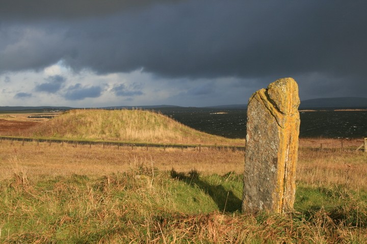
The Comet Stone looking very phallic, with Fresh Knowe in the background.

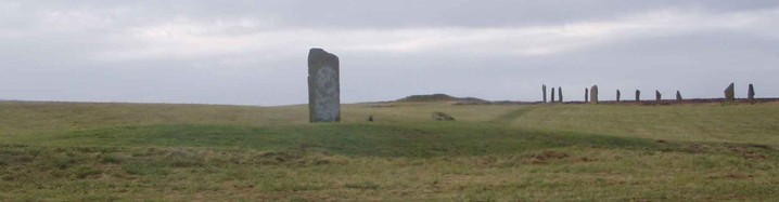
Around 140 metres to the south-east of the Ring o’ Brodgar is the monolith known as the Comet Stone.
Standing 1.75 metres high (5ft 9in), the Comet Stone stands on a low oval platform measuring around 14 metres (45ft) in diameter and about 80cm (31.5 inches).
The monolith appears to have once been part of a group of stones, the only evidence of which are the stumps of two broken stones.
Info source:orkneyjar.com/history/monoliths/cometstone.htm

odd bumps N of Comets Stone mound (L of image) are low linear feature headed for the west half of it

view SE along Axis A and across Axis B stones
Axis A across Stub i to Comet Stone and beyond (Ness of Brodgar excavation visible to left of Commet Stone)

Axis B from Stub i to Stub ii

top of Stub iii continues at least 4cm under the grass

Comet view of Wasbister skyline with Ring of Bookan (left) and Wadbister/Bookan cairns, former aligning to stone

Ness of Brodgar excavation and Stones of Stenness from Comet Stone

view along Axis A with stub iii and Comet Stone, just visible top right edge of Ring of Brodgar

stub i showing wedge top

bands in stone break looking down on stub i


The Comet Stone in the foreground, looking to Brogar

taken from slide to show more clearly depression in which the stone itself sits .


Visited 26th October 2012
I’m quite fond of the Comet Stone, as Ellen and I got handfasted here in 2005. Also as Carl says in his fieldnotes, not many people bother to come out to see the stone, always in the shadow of its more impressive big brother, you can stand here and watch the coach loads of visitors process around the ring, with not one of them casting a glance towards the poor old Comet Stone.
As we approached the Ring of Brodgar on foot along the path from the Stones of Stenness we came to the Comet Stone first. Standing on the small mound on which the stone perches, storm clouds gather around us, and waves are being whipped up on the Loch of Harray. I can’t spot any sign of the two small stubby stones by the base of the Comet Stone, scrubby tufts of grass hiding them from sight.
You also get a great view of Brodgar on the horizon from here, but this lovely stone is reason enough to take a detour from the main stone circle to get up close and personal with it.
Visited 4.6.12
Although there were a fair few people milling around the Ring of Brodgar I was the only person taking the short walk to say ‘hello’ to this stone – which is a shame.
The stone is on a small mound (approx 1 metre high x 10 metres across) and is approx 2 metres tall x 1 metre across.
The stone is covered (for a change) in yellow lichen.
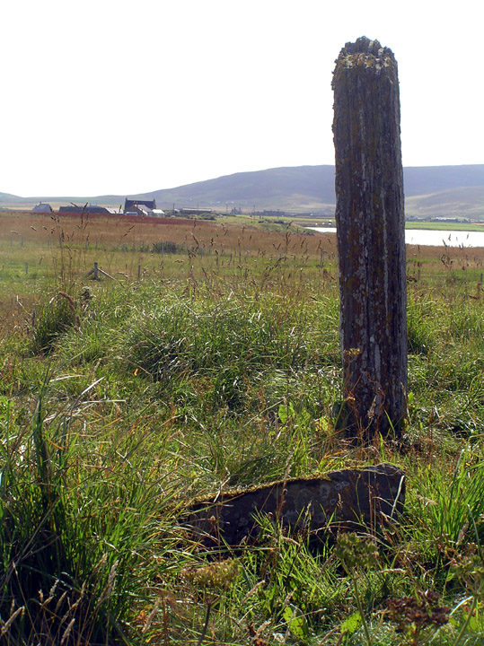
There are two stones sticking out of the ground at the stone’s base.
This is NOT visible from the Ring of Bookan, the skyline is the Bookan tomb with the mounds (The Brecks) about the old quarry.
This site shows how size isn’t everything. There was a complicated set of ceremonies surrounding matrimony involving all three rings and another Bookan site. Though nothing is recorded for this place, if the early name of Ulie Stane comes from dialect ullie ‘oil’ might I suggest a reference to chrism and perhaps ceremonies surrounding childbirth ? Note that this was the way to the Ring of Brodgar on the old track that ran through the “sacred monuments”, making it a gatekeeper kind-of – in the 19th century gentlemen still doffed their caps to it.
[My stone measurements are likely accurate but the distances between them and across the mound are as near as I could manage alone. {NMRS converted to metric} ]
The Comet Stone aligns NW/SE and sits in a depression presently measuring 2.7m by 2.3m and 20cm deep. The main stone stands 1.88m at the SE end {1.75m} and 1.97m at the NW, depth 27-28cm {29cm}, width 70cm at base increasing to 73 {76cm}. Measured height differs enough from NMRS to indicate surface erosion [there is a long scrape in the northern half too]. “Lines on the Landscape, Circles from the Sky” by Trevor Garnham gives an alignment to Maes Howe. but unless my compass reading is absolutely useless is incorrect this is not so, explaining why the meticulous antiquarians would miss such a thing- the alignment would seem, rather, to carry on to the Ring of Bookan [though this is on the hillslope invisible from here unless it stood higher formerly or had a superstructure such as a stone ring or posts] and perhaps ? to something roughly in the Dowsgarth region in the other direction. This NW/SE alignment is shared by the Stanerandy Tumulus (for a long while thought to be standing stones) and the Deepdale Stones, both on Mainland, and the Langsteeen on Rousay – we know so few s.s. orientations that there could well be more. The relationship with the recorded ‘stubs’ is striking, forming a geometric unequal tee-formation. Following the alignment 2.97m {2.67m} brings you to the western edge of Stub i and from that 2.75m takes you to the eastern edge of Stub ii. These define the mound’s axes. Axis A , defined by Comet to Stub i ‘W’, is perpendicular to Axis B which is along the line of the two stubs (a NE/SW alignment shared with the Watch Stone stump and the Spurdagrove s.s. pair). Using ‘mound’ for the area currently left rough then the mound is 16~16.5m along Axis A and ~11m along Axis B – NMRS gives approximate size of 13.7x12.8 and ~80cm high. At the edge, 6.5m from the Comet Stone’s SE end only a few inches away [
Wideford’s suggestion that the Comet stone not being part of a cove seems right to my untrained eye. The two little stones are just too wee. The mound is definitely there though.
I got the sense that the stone had been moved from it’s original setting, but couldn’t give a rational reason why.
HY 2963 1331. RCAHMS NMRS No. HY21SE 13.
From the main road this outlier is the first object you come to in the site that contains the Ring of Brodgar. Described usually as a standing stone the two short stumps on the same mound make this present more the appearance of another, much smaller, stone circle. Archaeologists have said that the two stumps are the remains of a cove in front of the main stone, but on the ground it is not obvious how more stones could fit into such a pattern here. What is very evident is that the Comet Stone itself stands in a fairly large circular depression atop the mound. I wonder if originally it stood by itself and then later was made into the centre of an observational platform?
Old men used to raise their bonnets whenever they passed this stone. The alternative name translates as ‘oil stone’, which would be to do with some lost ceremony greater than a tip of the cap.