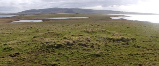
overall view of site, virtually to the track
Image credit: wideford
overall view of site, virtually to the track

area of buildings between main broch and ditch

main broch mound

ditch showing embankment on lip

broad ditch where it runs by the track
To reach this site go along the main Kirkwall-Stomness road until you reach the Harray junction, turn up towards Dounby and the follow the directions for Corrigall Farm Museum on the east side of the road. The farmroad is very long and windy. At the museum you can see the mound just a little behind the the farmyard itself, to the right of a broad steep track going up the ways. Unfortunately the persistent rain tipping down prevented my approach to any nearer than the fieldgate beween the museum and the farmhouse (and my brother that drove me is not even into mounds, never mind a brochaholic, so wouldn’t stay), but if you have transport it is well worth a visit if ruinous mounds are your thing. Best ask at Corrigall Farm Museum or the farmhouse for permission I think.
30s 3Mb video downloadable from rapidshare.com/files/457215914/Burrian_Corrigal.wmv as seen from Corrigall Farm Museum
RCAHMS NMRS record no. HY31NW 33 at HY32351937 is sheltered by the deep defile of the Burn of Corrigall at the south of the site but has been extensively (though fortunately not thoroughly) quarried in parts. The ground plan’s asymmetry resembles broch villages such as Aikerness (Gurness) and Lingro on a slightly smaller scale – on the order of Round Howe in overall size. The external diameter is in the region of 53’ with an estimated eight foot thick wall. Where the ditch about the broch is deeper, six drystane courses 4’6” high with an apparently completely vertical inner wall-face can still be seen over an 8’ stretch, elsewhere the foundations survive in a couple of places. At one time a fairly extensive passage 2’ wide came to light during farm works – the farmer having removed the stone infill then replaced this. A 33’ wide ditch appears to surround about half the central broch, being 40’ from it. This ditch is deeper at the north and north-west then comes to a sharp halt at the NE due to agricultural processes having levelled the ground. On its western lip an earthen bank still stands from 2’6”-5’6”, and now spreads about 9’ across. Between broch and ditch at all sides but the south are indeterminate walls, mutilation and ground disturbance obscuring the nature of the auxillary buildings there.