N/S stone on top of mound viewed from west side, tape extended to 1m mark
Image credit: wideford
N/S stone on top of mound viewed from west side, tape extended to 1m mark

N/S stone on top of mound viewed from above

Appiehouse Standing Stone

stone at top of mound

mound from nearly opposite Appiehouse

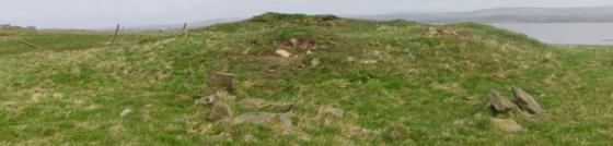
raised circular bits between mound and farmhouse

mound from near top of Stoneyhill Road, stone still not triangular
View from road 9.6.12
Time was against me so it was only going to be a ‘drive by’ view.
The mound was easy enough to spot when travelling south but I couldn’t see the stone.
Coming from the Dounby direction what can be mistaken for a second stone is the end of a ‘Nissen hut’ barn
The field is named Stenso from stens-a ‘standing stone burn’. Today the open gate gave entry. I found a N/S aligned stone at the top of the hill. It projects less than it is thick i.e. 6” or less. If this is the stone it has become further reduced this last couple of months, if not then it is previously unrecorded. I had my photos but a tractor man ordered me off before I could take measure of the thing. He said that I wasn’t allowed and the land was private [an English derived conceit]. After the bullying I forgot to check from the road for the proper s.s. if this wasn’t it and doubt I’ll dare again.
Continuing up the Dounby road past the Howe crossroads, the Appiehouse Stone is at the top of the mound that can be seen behind the farm on your left. I have never found it before as coming from this direction it is basically invisible – the first sighting is when you look carefully as you come level with the summit. Coming from the Dounby direction it is much easier to see. Only it looks rather unlike the photo on the site record, being equally irregular in shape but nearer a rectangle than a triangle, unless it manages to look drastically different on the other face. Alas the presence of sheep in such a relatively small space meant I couldn’t check inside the field to confirm or deny the apparent further reduction in height. On the northern side there is a big dip with a steep rise, but this is not regarded as a connected bank/ditch as there are more similar behind it.
On the southern side there are a few projecting stones distant from one another, but the mound is believed to be natural. However, in 2004 in the course of building works part of a stone structure came to light and they had to re-route the pipe around the mound. Unfortunately where this structure stood vis-a-vis the mound itself is not noted. On the southern side between the mound and the farm I spotted two very small very shallow circular mounds a few inches high, of which the more obvious one looks to have at least one stone projecting either close by or at the edge. Something to do with the structure or relating to the pipe, or simply natural ?
John Fraser in the first volume of the Proceedings of the Orkney Antiquarian Society describes a N/S alignment for the 4’ by 4’ remains of a once larger standing stone. Come the 1946 Inventory and it is a triangular 6½” thick stone of dimensions 2’9” by 3’3”. But the record card photo in the Orkney Library’s Orkney Room shows a rectangular portion below a roughly triangular top, and the sharp curve on the LH side looks like an outsize bulb of percussion from a hard blow. And now, un-noted, the stone has possibly been further reduced in height to just the lower half.