
Traeth Mawr from near Whitmore Stairs
Image credit: Robert Gladstone
Traeth Mawr from near Whitmore Stairs

Looking toward distant Dunraven from Traeth Bach, the fort rears up top right.

The extraordinary location of the site viewed descending to Traeth Bach.... incidentally by long, metal ladders.


The enclosure from the cliff line to approx south... the rucksack (centre left) sits upon the defensive bank.

Looking up at the towering cliff line from Traeth Bach... the enclosure surmounts the left hand crags.

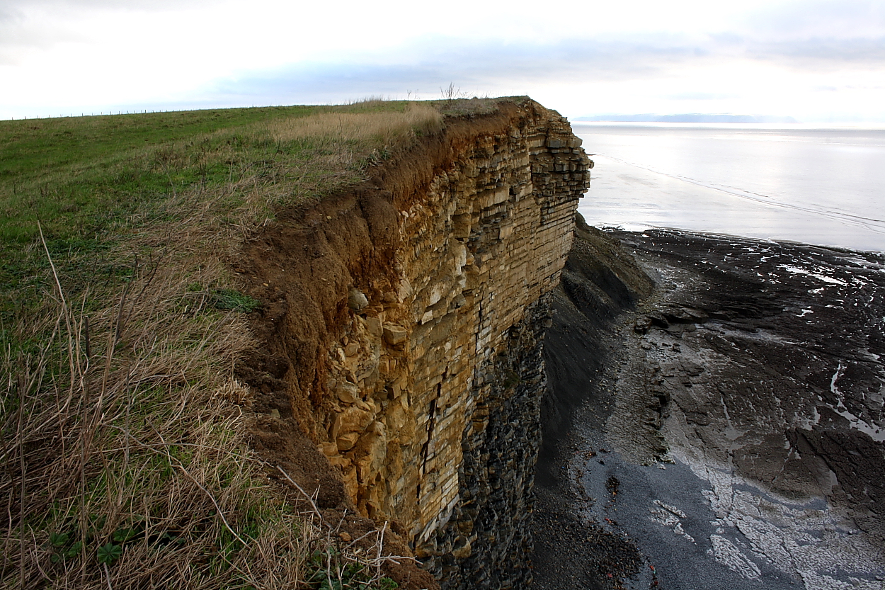
Looking approx north-west towards another promontory fort at Dunraven, background left. Note the seriously crumbling edge...

The flat interior of the enclosure, seen from across the Cwm from the north.

The northern slopes down to the Cwm really are very steep. Looking east.

Looking down into Cwm Bach from the northern edge of the enclosure.

The northern side of the enclosure falls very steeply down to Cwm Bach itself. The headland in the distance is Dunraven, the most westerly of the chain of Glamorgan coastal forts.

Looking SE across the interior of the enclosure towards the rampart.

The ditch and bank of the single rampart cutting off the promontory.

Approaching Cwm Bach enclosure from the SW, the single rampart prominent ahead.

Whitmore Stairs enclosure. Contender for least-impressive prehistoric earthwork on TMA? The very low remains of a bank curve from the bottom right corner to centre left. Luckily the cliff-top setting makes up for the lack of visible remains. Porthcawl can be seen in the distance, top left skyline.

A stark warning as to the dangers of these cliffs. The grass-topped area in the left foreground is an enormous chunk of slipped cliff, hundreds of tons of rock that has simply detached itself from the rest of the face. Whitmore Stairs enclosure (what’s left of it) is on the headland ahead.

The cliff fort at dusk viewed across the jaws of Cwm Bach to the approx north-west. Incidentally the viewpoint is the site of a further, much smaller earthwork, very difficult to make out.

Black celebration upon the Cwm Bach rampart.

Looking along the bank towards Cwm Bach. Note the well preserved ditch.

Looking approx south-east from the northern (and longest) section of bank. The southern section can be seen far right, terminating at cliff-edge.

The defences are univallate and of no great length, albeit of quite substantial construction.... the location requires no more.

Cwm Bach provides ample protection for the promontory/cliff fort’s northern flank, seen here to the left of image.
A ‘view from afar’ 4.5.14
Directions:
East along the coastal path from Dunraven Hillfort
I would say that the creation of the coastal path around Wales is one of the best things the Welsh Government has done. It really is a great place to walk although you do have to take care as the path is often very close to the cliff edge and there is very little in the way of protective fences etc.
We passed through two kissing-gates and eventually came to a stone wall, where the path continues down through a gorge and then up to the Cwm Bach site. Dafydd had been moaning most of the way and said he was too tired to walk any further and no doubt he wanted to get onto the beach – which was fair enough. He said that I should go on alone and come back for him. Given that he is only 6 and we were on top of a cliff this was clearly not an option! I would have to admit defeat on this one.
However, on the plus side, the single grass covered curving bank of the enclosure could be clearly seen in the distance. It was difficult to determine the height of the bank from this distance but I would guess at about 1 metre.
One for another day perhaps?
On the way back we walked through the pretty Dunraven walled gardens.
Funnily enough as we reached the beach Dafydd’s legs suddenly got better and he was even able to manage a jog – spade in hand of course!
Excellent little cliff fort – one of a linear chain gracing this Glamorgan coastline – overlooking Traeth Bach and most easily reached by a footpath from the minor road to the approx east. Note that it’s possible to park a car near the junction with the Tre-pit Road (a little west of Wick).
Protected by the steep defile of Cwm Bach to the north and vertiginous cliffs to the west, artificial defences are only really required elsewhere.
According to Coflein:
“Two discrete lengths of bank, ditched on the SE, the northernmost c.40m NE-SW by 10m and 2.0m high, the other c.33.5m NE-SW by 8.5m and 1.5-2.6m high, truncated on the SW, together appear to define the SE side of a roughly triangular enclosure, resting on an eroding cliff-line on the SW and defined by scarps above the Cwm Bach on the N. Air photos suggest that the southern rampart segment continues N of entrance gap, behind line of the north rampart.” J.Wiles 26.01.04


