
view from near passage end to entrance
Image credit: wideford
view from near passage end to entrance

collapse near very end of passage
passage wall height

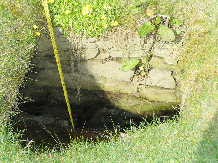
exposed part in northern section

passage viewed from entrance
NOT A KNOWN FEATURE
My first notice of this feature came when walking the Crantit footpath from the town end. Reaching the corner where it turns back down to the main road and looking across I spotted a lintelled entrance over the other side of the ‘drain’ there, at the corner of the field with what looked to be the remains of a low mound over it (HY4415709002). The feature being above water level, and the piece of ground about the base reasonably firm (neither of which is usually the case), I jumped across the burn. It is composed of drystane walls and flags covered the bottom. At some time an attempt has been made to consolidate the entrance with cement. Though by crouching I could get inside I bottled out of waddling through the entire tunnel in case of sticking, especially as I could see one place near to where the roof had opened up. At that time I did not think to see much at ground level. Of course there was also Petrie’s tomb “close to the shore of Scapa” [not the same as another he dug south of Lingro whilst engaged on the broch but perhaps up on the same side of the bay].
I felt that it stood an outside chance of being the ‘true’ Crantit earthhouse as this entire area, probably once an oyce [tidal inlet], used to be part of the Crantit Estate. The early O.S. maps show nothing for this field, not even a well it might have connected too even though there there were a couple closer to Nether Scapa itself. There are ‘drains’ and straightened waterways throughout the estate, but these are very strictly gridded and do not follow the same alignment. Stepping Stones were marked at a Burn of Crantit bend to the SSW, which is the only other existant (pre)historic feature in the vicinity if it hasn’t been dredged out.
This year after looking in the field the O.S. placed their suggested souterrain (all I found was a stone socket, just possibly a short cist, underneath the fence along the field’s northern border) I went for a better look at my ‘find’ in the next field. This lies near to the western edge where the burn is but runs at an angle to the field edge. Its far end is under a slight rise near what seems to be the first of a short series of old dunes. Between this and the entrance is fairly level, which is what you would expect had this been merely a drain. The passage is covered with thick slabs of ‘unnecessary’ width as shown in several places where these covering stones have somehow fallen in. There appeared to be no more to this feature, though before the entrance is reached there does appear to be a kink – two roofing slabs do not look to point directly to the entrance, however it would need twa folk to check on this together. Even if it weren’t for the notable disparity in alignment despite the slight resemblance of the walling to parts of the Agricultural Improvement ‘drains’ said parts only cover the two or so metres necessary to go from field to field, the rest being uncovered.
I had a few doubts, but the week after I happened to look through my newspaper clippings and found a photo of a feature very like my passage. This was someone in 1995 asking if anyone could recognise where the tomb in said photo had been !! Unfortunately there were stone fieldwalls in the photo and the hills didn’t look to match the view I remembered. Alas nobody answered the querent. Still I hesitated over publishing this site in case (against the odds) I were sadly mistaken as to its age. Then last week I saw three couples with dogs crossing the field, which was very weird. They were nowhere near the passage but in case someone is planning on developing the field I am risking possible humiliation in order that it should be on record before it might suffer damage.
In the images the tape measure is extended to 1m mark.


