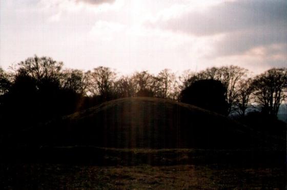
The barrow from the north.
Image credit: Mike Rowland 02/10/2007.
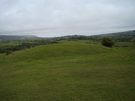
The barrow from the north.

From the east showing the damage done by badger setts.
This is a single bowl shaped barrow despite it’s name. I think the name comes from the fact that it is perched on top of a small hill which looks like an extension of the barrow. This positioning would have much more obvious in the past, sadly the barrow is now in a plantation of hideous fir trees.
The barrow itself is in poor condition, trees grow on it but most of the damage has been caused by badgers burrowing in to it. Although it is near a footpath it’s not easy to get to through the thick undergrowth, I had to dig quite a lot of thorns out of my jacket and trousers and I could have lived without the stinging nettles.
It appears to be an outlier from the barrow cemetery on Black hill several hundred metres to the east. Also to the west two barrows are marked as being extant on Tolpuddle Ball, which at some stage I’ll try and visit.
To the north west is Wetherby castle which stands prominent on a hill rising out of the valley floor.
Details of barrow on Pastscape
Bronze Age bowl barrow on the western end of a ridge overlooking the Piddle Valley to the south and the Bere Valley to the north. The monument concists of a mound 12m in diameter and 1.8m high surounded by an infilled ditch 1.5m high. Scheduled.
Double Barrow (Tumuli) O.E. (1)
? Possible Long Barrows. (2)
Two bowl barrows, both among firs and dense undergrowth, and both 8ft high. [a] SY 8208 9452; b) SY 8209 9452] (3)
Only one tumulus is surveyed and worthy of record at this site, it is situated at SY 8208 9452 and has the following measurements:- Diam. E/W 14.5m N/S 15.0m. Height 2.0m no trace of ditch, this mound is situated on steep N-S natural slope, the tumulus has weathered to the slope and measurements are accurate only to te nearest 0.5m. To the west of this mound the natural ground contour drops steeply in a precipitous way. I consider this wholly natural feature has been recorded in error as a second tumulus, however the whole area is densely over-grown with trees and thick undergrowth, burrowing by rabbits, and a great amount of soil strip have disfigured the original outline, and without excavation it is impossible to determine the original condition of this site. Re. Auth 2. this is not a long barrow, the a/m tumulus is complete within itself and is obviously a bowl. (4)
Surveyed. There is now only a single barrow situated on a small abrupt natural spur, and there is nothing on the ground to
suggest that there was ever anything more. Dimensions and description are as given in 4. (5)
SY 82089453. Double Barrow, a bowl barrow about 40ft diameter and about 8ft high near the west end of a spur. No evidence of a contigous barrow. (6)
SY 821945. Double Barrow, round barrow. Scheduled. (7)
SY 82099453. No change.
Re-surveyed at 1:2500 on M.S.D. (8)
--------------------------------------------------------------------------------
SOURCE TEXT
--------------------------------------------------------------------------------
( 1) Ordnance Survey Map (Scale / Date) OS 6” 1902
( 2) General reference OGS Crawford. Undated Rec. 6”
( 3) General reference L.V. Grinsell’s ‘List of Dorset Barrows’ (Unpublished)
( 4) Field Investigators Comments F1 FDC 09-JAN-53
( 5) Large Scale / Small Scale Map Revisers Comment SS Rev GSL 25-SEP-61
( 6) Royal Commission on Historical Monuments (England) 1970 An inventory of historical monuments in the County of Dorset. Volume two : south-east [in three parts] part 3, No 61 Page(s)434
( 7) by Department of the Environment, Ancient Monuments and Historic Buildings London 1978 List of ancient monuments in England: Volume 1, Northern England; Volume 2, Southern England; Volume 3, East Anglia and the Midlands Page(s)59
( 8) Field Investigators Comments F2 JGB 12-FEB-81