Details of barrow on Pastscape
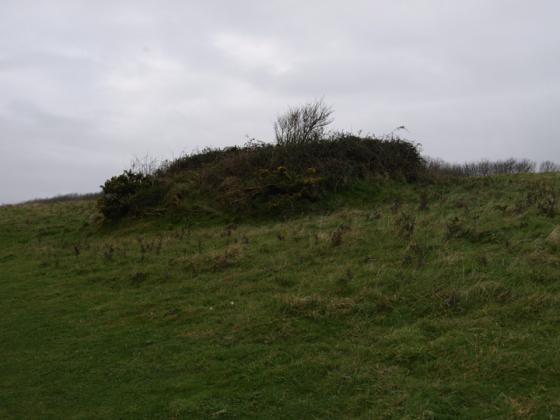
Bowl barrow 320m east of Bere Down Farm, on south facing slope of Bere Down and is part of a group of seven. The barrow is 22m in diameter, c.1.5m high and surrounded by a buried ditch c.2m wide. It was partly excavated in the 19th century.
(SY 84339685) Tumulus (NR) (1)
A grass-covered ditchless bowl barrow, 23.0m diameter and 1.6m high with a slight central excavation. A ‘Celtic’ type lynchet merges with the barrow on its south east side. A small Bronze Age sherd was found in a mole-hill a few metres south west of the barrow. (2)
SY 84349684 Ditched bowl barrow, 74ft diameter and 7ft high marked as “Hawks Barrow” on Isaac Taylor’s map 1777. It lies on a flat-topped spur, just below a ‘Celtic’ field lynchet (see SY 89 NW 33) and has been disturbed in the centre. A collared urn, in Dorset County Museum, apparently came from this barrow (a). (3-4)
SY 84339685. Bowl barrow, diameter 23.0 metres north-west/south-east and 20.5 metres north-east/south-west, height from 2.4 to 4.0 metres maximum. Not ploughed; in good preservation. No visible evidence of a ditch. The name ‘Hawks Barrow’ is not in current use.
Resurveyed at 1:2500 on M.S.D. (5)
SY 845971. Round Barrows on Bere Down. Scheduled. (Includes this barrow – see illustration). (6 – 7)
SY 84349684. Bere Regis 8. Round barrow listed, information as Authy 3. (8)
--------------------------------------------------------------------------------
SOURCE TEXT
--------------------------------------------------------------------------------
( 1) Ordnance Survey Map (Scale / Date) OS 6” 1902
( 2) Field Investigators Comments F1 GCS 29-SEP-54
( 3a) General reference P Dorset NH & AS 86 1964 p 115
( 3) General reference RCHM Dorset 2 pt 3 1970 437 No 112
( 4) General reference Dorset Barrows 1959 88 (L V Grinsell)
( 5) Field Investigators Comments F2 JGB 13-MAY-81
( 6) General reference DOE(IAM) AMs Eng 2 1978 59
( 7) General reference DOE(IAM) Record Form 02.09.60
( 8) General reference Dorset Barrows Supplement 1982 33 (L V Grinsell)