This photo shows the man made bank at the lowest point of the deep pond like feature with the banked channel leading to it.
Image credit: Mike Rowland 24/08/2007.
This photo shows the man made bank at the lowest point of the deep pond like feature with the banked channel leading to it.

This large bank crosses most of the site at a point below the circular feature.

The edge of what looks like a pond, it’s about 10 feet deep.

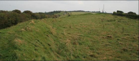
The outer, southern ditch of the round feature, looking across to it’s northern bank.

This is a very important site in Dorset, being as it is a complete set of earthworks consisting of a farmstead and celtic field system. The most distinctive part of the site is a round enclosure not unlike a large disc barrow in form. This consists of a single bank and ditch. There is an entrance with a sunken trackway with a bank either side of it leading into the circular enclosure not unlike “banjo” type enclosures seen on Salisbury plain and elsewhere. These features are almost always referred to as farms, they often have excavated signs of a round house and other structures within their interiors.
The rest of the site is criss-crossed by the low banks of square shaped celtic fields. Also there are four deep depressions at various points around the site which appear to be ponds, indeed the most prominent appears to have a double ditched channel leading into it. This particular “pond” also has a bank at it’s lowest point.
At a place south of the circular feature is much larger bank and ditch than those marking the field edges, being about two metres in height.
A settlement of the pre roman era near the tiny village of Turnworth. Although best seen from the air the remaning earthworks of this farmstead and field system can be seen on the ground. Access to the site is very easy as it is under the care of the national trust. Unfotunately my camera batteries died on my last visit, so photos will come when I next visit, which will be no great hardship as this is a quiet and gentle place.